In the last newsletter, I wrote about the possibility of the Atlantic hurricane season having below-normal activity due to El Nino. Now that we are approaching the end of the season, we can look back and see that while the season will likely end up below normal by several measures, it has been a bit more active than was anticipated a couple of months ago. As of early October, there have been 10 named storms (average is 12), three hurricanes (average is six), and one major hurricane (average is three). As I have stated many times, though, even in a quieter-than-normal season, it only takes one system in the wrong place at the wrong time to have a devastating impact.
Tragically, this has happened this year with major hurricane Joaquin. This system, while moving very slowly just to the east of the Bahamas, produced a long period of winds in excess of 100 knots leading to tremendous devastation on several islands in the eastern portion of the central Bahamas. Some descriptions have noted that some islands have been “completely obliterated,” and fatalities have been reported. This terrible situation has been overshadowed in the U.S. media by the tragic loss of the U.S.-flagged ship El Faro with all hands in the waters just to the east of the central Bahamas during the hurricane.
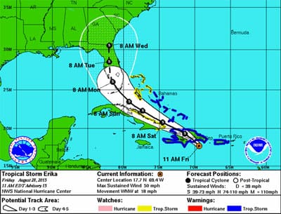
I want to start, though, by talking about tropical storm Erika. This system developed in the tropical Atlantic and tracked west in late August across the northern Leeward Islands (where it produced devastating rains for Dominica) and through the northeastern Caribbean, then crossed Haiti and far eastern Cuba before dissipating. Throughout most of its existence, Erika was impacted by upper-level wind shear, which limited its potential to strengthen even though other factors were favorable. Forecasts for diminishing upper-level wind shear once it moved out of the Caribbean and toward Florida were complicated by its likely interaction with the mountainous terrain of Haiti and eastern Cuba. The strength of the system during this time would have a significant impact on its track, and due to uncertainty with its strength there was great uncertainty with the track as well. This led to a situation toward the end of its existence where a track toward Florida was forecast along with strengthening; but, in the forecast discussions, the significant uncertainty was highlighted and the possibility that the system would not survive to reach Florida was mentioned somewhat prominently. However, the official forecasts did show the system moving toward Florida (Figure 1), and they received heavy media exposure right before a weekend. And, even though the Hurricane Center never issued watches or warnings for Florida (a correct decision), some folks in Florida were upset by the forecast that caused some to undertake preparations for a possible impact that ultimately did not occur.
 |
|
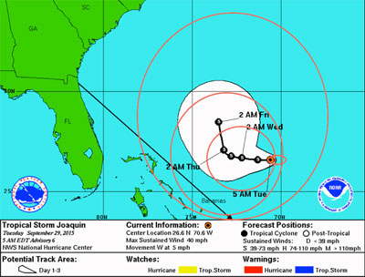
Figure 2. Forecast for Tropical Storm Joaquin from Tuesday, Sept. 29, 2015, at 5AM EDT, overlaid with 34-knot wind radius information plus error factors at the initial time, and 24, 48 and 72 hour forecast times comprising the 1-2-3 rule (in red). Direct route from Jacksonville, FL to San Juan, Puerto Rico shown in black. |
This led to an excellent blog post by the branch chief of the Hurricane Specialist Unit at NHC in early September looking back at the forecasting issues with Erika and commenting on the uncertainty of hurricane forecasting in general — it is well worth reading.
Remarkably, one of the suggestions made by the author — that of adding some key “talking points” to the forecast discussions — was implemented by the time hurricane Joaquin came along. Change in the methods of operation for government agencies often proceeds at a glacial pace, but in this case the suggested change came very quickly, and in time for another tropical cyclone where there was significant uncertainty. You can access one of the forecast discussions from Joaquin showing the use of this new method here.
By reading not only this discussion, but most of the discussions prepared through the early days of Joaquin’s existence, it becomes readily apparent that there was significantly more uncertainty than usual with this system, both in terms of its expected intensification rate and in terms of its projected movement. The situation around the system was very complex with many factors to consider, leading to many dramatically different possibilities for the evolution of the system. Most numerical simulations agreed that a rather sharp turn to the north would occur as the system approached the Bahamas from the east; however, the timing and “sharpness” of the turn were not at all clear, and the possibilities after the turn ranged from a major hurricane landfall in eastern North America anywhere from the Carolinas to Atlantic Canada, to a track that would keep the center of the system off the east coast, to a track near or over Bermuda and then northeast into the central Atlantic. The forecasters at the National Hurricane Center, who are required in their advisories every six hours to provide an expected track and intensity forecast for the storm, had an extremely difficult job with Joaquin. As noted in the blog post referenced above, much of the public focuses on the “cone” that is generated from these forecasts, but this product does not do a good job of indicating the uncertainty level of the forecast.
 |
|
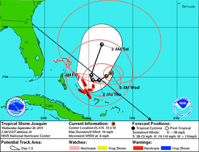
Figure 3. Forecast for Tropical Storm Joaquin from Wednesday, Sept. 30, 2015, at 5AM EDT, overlaid with 34-knot wind radius information plus error factors at the initial time, and 24, 48 and 72 hour forecast times comprising the 1-2-3 rule (in red). Note that Joaquin was just below hurricane strength at this time, and forecast to attain hurricane status within 12 hours. Direct route from Jacksonville, FL to San Juan, Puerto Rico shown in black. |
Examining the situation with the loss of the El Faro inevitably brings up questions about the captain’s decision to follow the route that he did. A tool that mariners can use to help with these decisions is called the 1-2-3 rule. For more information on the 1-2-3 rule, see my article in the 2014 issue of Ocean Voyager, or go to this NHC article following article — it’s a long article, a useful diagram of the 1-2-3 rule is on page 50. In a nutshell, the 1-2-3 rule keys in on the area around a tropical cyclone where sustained winds are expected to exceed 34 knots because this is the threshold at which navigation options for most ships become limited, perhaps forcing them to move into even worse conditions (stronger winds and higher seas). Thirty-four-knot wind radius information is given in every forecast advisory, and by using this information along with average forecast position errors for 24, 48 and 72 hour forecasts, a danger area to avoid can be constructed for the 72-hour period from the time of the advisory. It is critically important to realize that the “cone,” which is shown in the most widely viewed graphic products by the public, is NOT the same as the danger area given by the 1-2-3 rule. The cone is only an indication of the possible region where the center of the system may track, and since conditions on the water will still be dangerous well away from the center, the cone is not a good indication of the area to avoid.
To illustrate this, Figure 2 shows the 1-2-3 rule areas at each forecast time (initial, 24, 48 and 72 hours) superimposed on the cone graphic for the early morning of Sept. 29, the day that El Faro departed Jacksonville. The route of the ship toward San Juan is shown, and it can clearly be seen that the 1-2-3 area extends over the route while the cone does not. Figure 3 shows the same information from the advisory 24 hours later, early on Sept. 30, and it is obvious by looking at this graphic that the threat has increased significantly along the route. These questions must be asked: Given this information, why did El Faro depart Jacksonville on a direct route toward San Juan? After departure, as the situation appears to be deteriorating, why did the ship not abort the passage in order to move away from Joaquin and reduce their exposure to risk?
The uncertainty inherent in tropical cyclone forecasting will never disappear. Forecasting capabilities have dramatically improved through the last couple of decades, and this has resulted in the ability for much greater preparation in advance of the impact of a tropical storm or hurricane, which in turn has meant significantly less loss of life in connection with these storms. Sometimes the atmospheric factors affecting a given storm are fairly straightforward, allowing for higher confidence forecasts with longer lead times — and we have seen many examples of this in recent years. However, sometimes the atmospheric signals are unclear, such as in the cases of Erika and Joaquin this year, and we must accept that this will mean much greater uncertainty in the forecasts and take appropriate precautions, even if it means over-preparing at times.