Tropical cyclones, a broad term that includes tropical depressions, tropical storms, hurricanes and typhoons, are of great interest to ocean voyagers for obvious reasons. Information about these systems is contained in Tropical Cyclone Messages (TCMs) which are generated by the U.S. from three major tropical forecast centers: NOAA’s National Hurricane Center (NHC) in Miami which covers the North Atlantic, Caribbean, Gulf of Mexico, and eastern North Pacific; NOAA’s Central Pacific Hurricane Center in Honolulu which covers the central North Pacific; and the Joint Typhoon Warning Center at Pearl Harbor which covers the western North Pacific, South Pacific, and the Indian Ocean.
In addition, many other governments provide information about tropical cyclones affecting their territory and territorial waters. By going to the National Hurricane Center website (www.nhc.noaa.gov) links can be found to the other two major U.S. sites, and to many other websites worldwide.
Size of the wind field
The formats of the TCMs issued by these various sites are not all the same, but the types of information presented about each tropical system are consistent no matter the origin of the message. It is important to focus on the most critical information should one of these systems pose a threat to a voyage, whether planned or ongoing. Ashore, the mass media will focus on the strongest winds of the system (including the category from the Saffir-Simpson scale) and the position and forecast track of the center. However, for a vessel at sea, while these parameters are not unimportant, it is far more critical to focus on the size and shape of the wind field. In particular, the area where sustained wind speeds are at least tropical storm force (34 knots), or have the potential to be that strong, should be avoided.
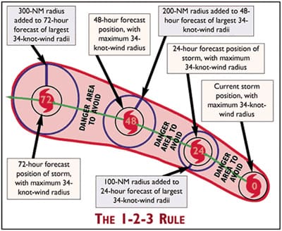
A tropical cyclone avoidance strategy using the 34-knot wind radius information, which is given in each TCM, along with an allowance factor for forecast error, is shown graphically and is known as the mariner’s 1-2-3 Rule. As shown in the graphic, the error factor is estimated as 100-nm for a 24-hour forecast, 200-nm for a 48-hour forecast, and 300-nm for a 72-hour forecast. At the time the 1-2-3 Rule was first devised, these were reasonable estimates for average track forecast errors, but as forecasts have improved, better error estimates would be 1, 2, and 3 degrees of latitude (60, 120, and 180 nm). In the graphic, the wind field is shown as symmetrical, but often this is not the case, and for this reason, the 34-knot wind radius information is given in quadrants in TCMs. By using the different values in the quadrants, the shape of the danger area will indicate which side of the tropical system needs to be given a wider berth.
The reason that the 34-knot wind radius is used as a benchmark for avoidance is that once sustained winds reach that level, the wind in combination with likely sea states accompanying it will limit navigation options for vessels, and may not permit them to safely move away from the system. This could result in rapid deterioration of conditions to the point that the vessel and crew could be in significant peril. The key with this strategy is to understand that whether the system is a moderate tropical storm or a Category 4 hurricane is of secondary importance to the 34-knot wind radius associated with the system. For example, Hurricane Andrew (1992), and Hurricane Floyd (1999) were both about the same strength as far as central pressure and maximum wind speeds were concerned, but Floyd’s wind field was nearly twice as big as Andrew’s.
Most all oceangoing yachts have the capability to endure reasonably well in winds of 34 knots or greater and their accompanying sea states, but typically in those conditions, the yacht will orient itself to best handle the situation by changing the heading with respect to the sea state, or even by heaving-to for a period of time. The difference when dealing with a tropical cyclone is that this strategy could lead to the rapid deterioration of conditions in a very short period of time.
Plot the 1-2-3 Rule
The 1-2-3 Rule is presented in graphic format for each system on the NHC website, but the process of putting pencil to paper and hand-plotting the danger area has benefits to the mariner. The process takes only about 10 minutes or so once mastered, and allows a much deeper understanding of the particular tropical storm or hurricane than does a quick glance at an Internet graphic. It is critical to plot the 1-2-3 Rule for each new TCM that is issued (normally every six hours) in order to visualize how the danger area is changing. It may be shifting toward or away from your area of concern, or it may be expanding or contracting. These trends are important avoidance strategy.
The easiest way to get TCMs is via the Internet, but if Internet access is not available while at sea, the messages are available through other methods, including NavTex, GMDSS, weatherfax, SSB broadcasts, via e-mail and private vendor’s software packages. Figure out how TCMs will be received and have a backup method in place for regular 1-2-3 Rule plotting should a tropical cyclone threaten.
————
Contributing editor Ken McKinley is the founder of Locus Weather in Camden, Maine.