Over the past couple of weeks, winter weather has made plenty of headlines in the central and eastern U.S. We have seen blizzard conditions affecting portions of the north central U.S., cold temperatures penetrating very far south into the southeastern U.S., including Florida where there have been impacts on agriculture, and strong winds along the East Coast and in the adjacent Atlantic waters. While it has been a somewhat unusually active weather pattern through this period, and some records have been set in some areas, the conditions experienced have not been unheard of at this time of year by any means.
Some of the more extreme weather has occurred downwind of the Great Lakes where large amounts of “lake effect” snow have occurred in portions of Michigan, Illinois, Indiana, Ohio, Pennsylvania and New York. The lake effect phenomenon is well known and is not that unusual at this time of year. The phenomenon occurs when cold air flows over the relatively warm lakes. The heat of the lakes leads to warming of the lowest levels of the atmosphere, which promotes rising air. When air rises in the atmosphere, it is cooled, and if enough upward motion (and thus enough cooling) results, then the air will reach its dew point and condensation will occur leading to cloud development. Eventually the clouds will produce precipitation. Also, during its trek across the lakes, the lower levels of the atmosphere pick up water vapor, which raises the dew point and makes more moisture available for condensation and precipitation. This precipitation manifests itself as localized areas of snow (or rain) downwind of the lakes, and in areas where there is significant terrain and the air is forced to rise over hills and mountains, this process will wring even more precipitation out of the air. Thus, some of the heaviest lake effect snows occur in portions of the Adirondack mountains to the east of Lake Ontario.
A very similar phenomenon sometimes occurs over the ocean off the East Coast of the U.S. and Canada. It doesn’t get as much media attention for a few reasons, most importantly that nobody lives over the ocean, and there are no roads to get clogged by snow. Also, typically the precipitation generated is not quite as heavy as the Great Lakes situation because the difference in temperature between the air and the water is usually not as great (the air usually isn’t quite as cold, and the water is not as warm during the late fall and early winter). Also, there is no terrain over the ocean to enhance the formation of precipitation. In fact, often the effect will lead only to the formation of clouds without significant precipitation, but in certain situations, bands of precipitation will occur.
Luckily, for most recreational mariners, this “ocean effect” occurs at a time of year when their boats are on trailers or jackstands, covered with shrink-wrap, or in a shed. However, it can occur in connection with a particularly cold air mass moving off the coast during the fall, so those who are trying to extend their season a bit, or perhaps making a southbound delivery may encounter the phenomena. Of course, professional fishermen and other professional mariners will experience it more frequently as they remain on the water through the cold season.
The parameters for the situation are very similar to the lake effect scenario, thus it will occur when rather cold air flows over the warmer ocean waters. Once the air has been over the water long enough (i.e. a bit offshore), rising motion will be induced by the warming of the lowest levels of the air, and clouds will form. Bands of precipitation may develop from these clouds if the temperature difference between the air and the water is large enough. This situation will frequently occur behind a cold front which has moved off the coast. Typically a cold front will be accompanied by showers, then clearing skies are likely after the front has passed and the colder and drier air mass moves in. Forecasts in coastal locations will indicate this progression of events, but offshore the situation may be different with clearing skies initially followed by the ocean effect conditions described above.
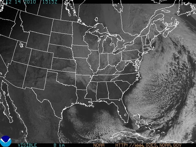
The accompanying satellite photo shows an excellent example of ocean effect conditions. In this situation, a low pressure was centered north of Maine with a cold front extending southeast across Nova Scotia into the Atlantic. The cold front continues southeast off the eastern edge of the photo, then turns more southwest back into the photo and extends to the island of Hispaniola in the lower right portion of the photo. This was one of the situations over the past couple of weeks where cold air penetrated unusually far south in the eastern U.S., and the circulation around the low was generating west or northwest winds throughout the eastern U.S. and western Atlantic at the time of the photo. If you examine the photo carefully, bands of lake effect snow can be seen extending off the eastern Great Lakes, especially one that extends from central Lake Erie southeast well into western Pennsylvania. Also notice that much of the eastern seaboard has clear skies with the cold dry air behind the front having moved in. Once over the warmer ocean, though, the ocean effect phenomenon is easily visible with the edge of the clouds almost exactly parallel to the coastline all the way from New England to Florida. The hole in the clouds east of Massachusetts was due to the fact that the coldest air had not yet moved into that region. The somewhat greater separation between the coast and the cloud edge south of Cape Hatteras was due to the fact that the air was not quite as cold this far south, so the temperature difference between the air and the ocean was not as great until the air moved over the Gulf Stream where the water was warmer. Radar images available at this time indicated some light bands of precipitation over the offshore waters south of Long Island in the mid-Atlantic waters.
So if you happen to be operating over the Atlantic waters when a particularly cold air mass follows a cold front, be aware that despite shoreside forecasts of clearing, windy and colder conditions, offshore it is very likely that considerable clouds will be experienced, possibly with some precipitation at times.