Dock-to-dock Autorouting
You've no doubt read about the wonders of Google's self-driving cars that will take you from point A to point B safely while you do important things like drinking coffee and using Snapchat. I hope boating never gets to that point, but Navionics has taken a step in that direction with a new component in Navionics+, an optional pay-to-subscribe feature available in their free Boating app, or included with their paid Boating app. Check it out here. It is available for iPhone and iPad at this time.
We all have used chartplotters that let us create straight-line routes between various selected waypoints, but what if your trip is down the Hudson River or the Intracoastal Waterway? Plotting a course mark-to-mark would be totally impractical in many areas due to the tight curvature of the waterway, the lack of navigation aids within sight of one another and the need to travel in non-straight lines. Dock-to-dock Autorouting to the rescue!
This app feature does just what it says — it plots a course for you, based on navigation aids and chart information, down a narrow twisting channel. Having traveled the Intracoastal Waterway more than 25 times, I can appreciate the need for this. I picture myself rising early to catch the sun in a desolate stretch of the Carolina or Georgia waterway, where the channel resembles a series of wriggling snakes. Yes, there are lots of markers to watch for, and you should be using your Mark 1 Eyeballs too, but it would be really cool on that chilly morning to have my day pre-plotted for me.
There are many places in such a snake den where intersecting channels or waterways can take you from instant calm to panicked confusion, often followed by your keel making the determination that your morning coffee-starved brain made the wrong snap decision. Having a plotted route would avoid all that fun of rowing out an anchor to kedge your boat back into deep water.
Not only that, but this app feature also provides you with fuel consumption, distance and ETA estimates, hazard warnings and points of interest. Needless to say, Navionics provides the obvious disclaimer that "a route automatically calculated by Autorouting does not replace safe navigation practices and should never be your only reference." In other words, boating with your mind in gear is still the safe way to get from point A to B, especially when the straight line is not the shortest distance between two points.
Cuba, here we come!
Now that sailing to Cuba seems to be possible for many North Americans, everyone is looking for charts and guides — and NV Charts has delivered. They've recently released four charting regions covering the north coast of Cuba, and they have matching chart apps. If you purchase the paper chartbooks, you can also download digital charts that work with a free charting program for OSX and Windows, and you will receive a free charting app for use on iOS and Android. Learn more here.
I like this approach of encouraging cruisers to have paper and digital products; it means you are not entirely dependent on the flow of electrons in a marine environment. At the same time, how cool is it to have your big chartbook safely below on the chart table, while your hand-held phone or tablet provides the cockpit view you need? Or vice versa, depending on your boat.
NV Charts utilize both government hydrographic information and the company's own surveys conducted in small boats. They utilize symbols and colors somewhat different than those used by U.S. government charting agencies, but I have found them to generally be clear and easy to read. As always, boaters must use caution and those Mark 1 Eyeballs when navigating in less-traveled waters, particularly coral areas.
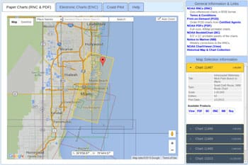
Office of Coast Survey Chart Catalog
OK, how cool can a chart catalog be? Pretty cool if you are the Coast Survey folks that bring us NOAA paper and electronic charts. Check out their online catalog here to see what I mean. Choose a tab to see outlines of paper or electronic charts available and, using Google maps, you can zoom right in smoothly and quickly to the area you are interested in and you can highlight chart areas to get more information.
The view includes quick links to navigational products covering the selected area, and lists other charts in the vicinity. This is a fantastic planning tool, and it also helps to give you a big picture of the area.
John J. Kettlewell is a marine author, editor and photographer. He and his wife Leslie are co-authors of the Intracoastal Waterway Chartbook: Norfolk, Virginia, to Miami, Florida.