Various electronic products are marketed as marine safety devices, but the decision about which ones to purchase poses a challenge as we wade through a complex array of technology solutions that don’t coalesce into just one device. For most voyagers this means selecting a complement of safety electronics to cover the many safety concerns we face: collision avoidance, search and rescue, position tracking and remote communication. No single device does everything, leaving us to compare and contrast product features, reliability claims, pricing schemes, flexibility and ease-of-use. A complex web must woven before capturing the perfect balance of electronic safety tools to have aboard.
We’ll focus on safety electronics that transmit info via the radio spectrum: EPIRB, PLB, AIS, SAR transponders, satellite phones, active radar reflectors, send-capable units and satellite trackers. Some multi-purpose devices are strong in one category but may also offer add-on features that substitute the function of another single-purpose device (which, arguably, are not created equal).
Before delving into specifics, and leaving seamanship discussion aside for now, let’s take a moment to consider our personal view of safety in the modern world, with knowledge that certain safety products are available off-the-shelf in the electronic marketplace. Our beliefs about safety may fall somewhere between traditional thinking and high-tech guru; yet, even if we have an unlimited budget, we still must make a personal investment in learning how to operate any device, and actually commit to using it My point is that if we’re going to be “safer,” not just feel safer, we shouldn’t allow product specifications to heavily influence good seamanship decisions, but rather implement new safety electronics aboard our boats in ways that allow us to manage our core beliefs and daily habits.
For example, a satellite telephone is incredibly useful if we simply enjoy calling someone and having a conversation (what’s the weather forecast, we’re becalmed and almost out of food, etc.); but, if I fall overboard without my satphone because I’m not tethered-in, and I’m lucky enough to be wearing my personal locator beacon (PLB), I stand a good chance that someone will know my predicament and launch a rescue mission. Such beliefs are personal and specific to each of us, and fortunately there’s good practice coupled with a plethora of electronic products for us to purchase and use.
AIS and active radar reflectors
Now for a deeper discussion of individual electronic safety devices, beginning with collision avoidance. According to the International Regulations for Preventing Collisions at Sea, Rule 7, if risk of collision is suspected with another vessel, the rule mandates an obvious seamanship practice: “obtain early warning of risk of collision [using] radar plotting or equivalent systematic observation of detected objects.” This article doesn’t delve into radar plotting as a safety device; instead we’ll look at automatic identification system (AIS) as a tool to practice good seamanship.
AIS identifies and locates all vessels participating in the AIS program by automatically exchanging data via radio frequency transmission. All commercial vessels operating in U.S. waters — according to 46 U.S. Code 70114, and according to the USCG AIS Rule Change issued January 2015 modifying the “commercial vessel” definition as self-propelled vessels of 65 feet or more — must install a USCG type approved AIS transponder by March 1, 2016. The International Maritime Organization’s regulation pertaining to the Convention for the Safety of Life at Sea requires AIS to be fitted aboard international ships with 300-plus gross tons, including all passenger ships, regardless of size.
 |
|
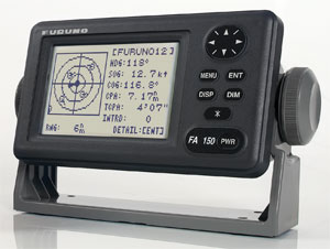
An automatic identification system (AIS) unit from Furuno. The FA150 is a Class B unit designed for small commercial and recreational vessels. |
|
Courtesy Furuno |
By design, the AIS device collects, stores, transmits and receives two reports describing a vessel’s position and static information. The position report contains speed over ground, course over ground, latitude, longitude and more. The static report provides vessel details: name, cargo type, destination, etc. These reports are transmitted from the device for receipt aboard any another vessel’s AIS device via data modulation on VHF carrier frequencies (161.975 and 162.025 MHz). Only one channel is required, but two are used to avoid interference problems and prevent communication loss by shifting channels as necessary. All vessels within reception range will show their position and static info on a screen, or spatially portrayed on a chartplotter so the movements of all the AIS vessels in range may be tracked and avoided. Post-processed data also provides value-added features like time to closest approach and distance at closest approach between your vessel and any other using AIS. Many marine electronics companies offer AIS devices now. Icom, for example, has the MA-500TR Class B AIS transponder and Furuno has the FA150 Class B AIS.
In reality, there are still several large vessels cruising around not broadcasting their info on AIS. This year I’ve come across several commercial vessels of more than 300 gross tons in Atlantic international waters, plus a few U.S. Navy warships in coastal U.S. waters that are not broadcasting any AIS signal at all. Note: USN vessels sometimes use AIS but they’re not obligated to, and you’d think they’d be looking out for you. However, according to my colleague who nearly got rammed by a warship this year between Bermuda and Newport, the warship wasn’t looking out. Many recreational vessels haven’t embraced AIS yet, so they don’t show up in the system either. Any of the above could be sailing alongside at night, in the fog or in broad daylight.
Commercial vessels also must install and operate AIS Class A units, which are more expensive than the AIS Class B units used by a majority of recreational boaters. It’s noteworthy to report that some commercial operators are setting their AIS display features to only show Class A vessels because some display software use a screen icon to denote an AIS vessel, resulting in a cluttered and unreadable screen with numerous Class A and B vessels displayed. As a result, the commercial vessel crews may still remain oblivious to recreational vessels’ positions within the AIS system.
However, if we have AIS aboard, we can still glean great info from those who are properly participating and hopefully avoid collisions at sea!
Another safety device used to avoid collisions is an active radar reflector (ARR). It does so by enhancing the radar target on the screen, and has proven in comparison testing to present the strongest reflected image in practice. An ARR receives an incoming radar pulse from another ship, electronically amplifies it and re-transmits the pulse. On occasion, ARR devices have been known to amplify the pulse from the radar transmission aboard the same vessel they’re on, and the solution is to simply turn off the ARR when using onboard radar.
 |
|
The YB3i unit from YB Tracking is designed for installed use. The YB3i uses GPS for positioning and tracking and can also send and receive SMS messages when paired with a Bluetooth device. |
|
Courtesy YB Tracking |
ARR devices work in the X-band frequency at 9.4 GHz to provide a crisp, high-resolution image. This is important to understand because an ARR won’t be “seen” on radar instrumentation set for S-band frequencies attenuated to blank out precipitation. I’ve been aboard several yachts where we used X- and S-band radar simultaneously, once dodging heavy squalls from a severe thunderstorm at night in the mouth of the Chesapeake Bay, surrounded by ships. We were delighted that both bands work great in their intended region: X to see all reflected objects including rain, and S to see reflections unaffected by rain.
One thing’s for certain, if you want to be seen by another crew working X-band radar, the ARR is your best option — the ARR’s amplified image is stupendous.
EPIRB, PLB and SART
Emergency position indicating radio beacons (EPIRBs) transmit a distress message in compliance with standards defined by Cospas-Sarsat, an international consortium of nations devoted to maintaining the satellite-based communications of the EPIRB system; they also coordinate SAR efforts initiated by the device’s distress message.
EPIRB devices are designed, manufactured and distributed by private firms competing for market share that develop their radio beacon devices from the performance specification and design guideline published by Cospas-Sarsat. These safety devices are tested and certified, but how they’re engineered and manufactured to do this is proprietary. EPIRBs need to pass specific tests regarding power, modulation, shock, frequency holding, buoyancy, etc.
EPIRBs can be activated manually or automatically by immersion in water. The manual activation switch is a point of product differentiation, but the most significant development in EPIRB technology is the added transmission of the beacon’s location as determined by an integrated GPS chip included in most EPIRBs sold today to nail down your location.
Upon activation, the EPIRB transmits a short-burst coded distress message on a dedicated frequency of 406 MHz; then, this message is transmitted again in short bursts every 50 seconds, on average. The staggered burst transmissions are in consideration of any other EPIRB message being transmitted around the same time; it’s handled this way so all these devices sharing the 406 MHz frequency don’t overlap and can be heard by the geosynchronous and low earth-orbiting satellite constellation of Cospas-Sarsat.
 |
|
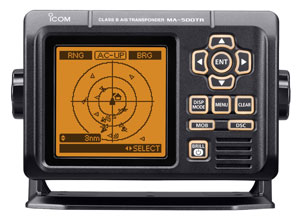
Icom’s MA-500 TR Class B AIS. Unlike Class A units, Class B models broadcast a reduced set of vessel info — just the key items to allow for collision avoidance. |
|
Courtesy Icom |
In order for our distressed location to be known and rescue efforts to commence, the Cospas-Sarsat system relies on the Doppler frequency-shift method to locate the distress signal, despite having an integrated GPS, at least until the Doppler track coincides with the GPS track. It’s argued that modern 406 MHz beacons can help resolve a search area to 2 square kilometers using the Doppler technique, but when the redundancy of the two measurements (Doppler and GPS) are confirmed, the location is sufficiently known to within 100 meters.
Registering an EPIRB is vital to rescue. Each device is encoded with a unique serial number that must be registered with www.406registration.com in order for important personal information to be provided for reference during a distress: emergency phone numbers, description of the vessel and other pertinent info, such as itinerary. Proper registration allows SAR efforts to be conducted more quickly, mostly because false alarms can be eliminated.
Personal locator beacons (PLB) use the Cospas-Sarsat system the same as EPIRBs do; they only differ in their performance specification and their smaller size for personal use. The primary difference between PLB and EPIRB is that the battery life for the PLB is specified at 24 hours, while the EPIRB is double that. PLBs are not required to be waterproof, although many are, so check the product listing carefully if you’re using your PLB for boating as opposed to hiking.
Another very useful SAR tool, especially aboard life rafts, is the search-and-rescue transponder (SART). These devices can broadcast your distress signal to a vessel passing nearby, and when used in conjunction with signal flares, your chances to be noticed and rescued are greatly heightened. There are two types of SAR-transponders: radar-SART and AIS-SART.
When the radar-based SART detects an incoming radar pulse in the X-band region, the device automatically transmits a unique response signal that appears on the vessel’s radar screen as a line of dots pointing to the SART device. The signal is so unique that even someone unfamiliar with its out-of-the-ordinary pattern should take notice and look in its direction to find the source.
The AIS-based SART instantly transforms your distress situation into an AIS “vessel” with the added benefit of transmitting your GPS coordinates. In an emergency, your position will be displayed as an AIS target on the screen of all vessels using AIS in range of the transmission. This device is akin to a PLB and could be used as personal man-overboard device.
 |
|
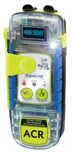
The AquaLink View PLB from ACR. |
|
Courtesy ACR |
Satphones, satellite trackers and send-capable units
Having a spoken conversation with someone on the opposite side of the globe offers tremendous safety possibilities. We can describe the nature of our distress, provide our location and even obtain advice. Satphones can also transmit and receive digital data and connect to computers to run various apps, such as email, weather routing and social media.
However, satphones are not commodity products. Obviously, individual product features vary from device to device, but so does the technology, engineering and manufacturing. Consider any device that incorporates radio frequency (RF): We know its manufacturer has to abide by strict international regulation to coordinate the device’s use of the precious electromagnetic spectrum; and, when we weigh earth-to-space transmission, we further appreciate how satellite constellations (government and private) become important to global communication. Satphones operate on specific radio frequencies that must be licensed and paid for, and the cost of satellite infrastructure is very high. Design teams compete to ensure their devices meet regulated and tested specs on transmission reliability, battery life, etc., and strive for efficient component designs that can be manufactured cost-effectively — like an antenna that performs well in a “sweet frequency” and can operate under a multitude of transmission angles. Furthermore, modulation schemes not only transmit and receive info on a single carrier frequency, but also handle interference from simultaneous transmissions by multiple devices competing to be heard on a shared frequency.
“Global coverage” is what most satphone companies claim. I’ve personally used satphones by Iridium, Inmarsat and Globalstar [Globalstar is not a worldwide system] in the middle of the ocean, and I’ve held successful conversations with each phone. But, I’ve also experienced times when none of them would get a signal. In the end, they’re telephones that work sometimes, virtually anywhere.
Probably the most significant complaint I’ve had with any hand-held satphone is how difficult it’s been to hear what the other person is saying while operating a yacht under normal offshore conditions. Noise from waves hitting the hull, wind, running machinery — even while using a head set, a conversation can be difficult to hear. With one professional weather router I spoke to daily via satphone, I had to explain to him after the trip to speak up during offshore satphone conversations. Even his receptionist was heard more clearly upon greeting my call!
Of them all, Inmarsat (transmitting at 1525 MHz) purports the loftiest claims of reliability and, based on their tight-knit association with the Global Maritime Distress and Safety System and the sheer volume of products and services they offer, I’d say it’s likely they know their business well. Inmarsat primarily services the shipping industry, but they’re definitely worthy of consideration for yachting too.
 |
|
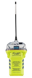
ACR’s GlobalFix iPro EPIRB. Both these units have GPS receivers and digital status displays. |
|
Courtesy ACR |
Iridium transmits at 1616 MHz and seems geared toward voyagers. They offer exciting products, not only because they sell good satphones but because they license their Iridium 9602 modem for data communication in satellite trackers such as those marketed by YB Tracking and DeLorme.
The YB3 Tracker is an easy-to-use location and data communication device that transmits a vessel’s location (acquired by integrated GPS) on a regular basis with incredible battery life, providing nine months of power and sending two locations per day! The regularity of daily transmissions can be changed, and the YB3 also allows two-way messaging of up to 250 characters per message sent to another phone, email or social media. It’s also incredibly robust and the most popular tracking device for high-profile yacht racing and cruising rallies around the world, offering web-based maps for plotting the tracked vessel’s position.
Another device that incorporates the Iridium 9602 modem is DeLorme inReach, which contains all the functionality of the YB3 with the added feature of SOS Alerting, which sends a distress message to a privatized SAR coordinator called GEOS Worldwide, which (like Cospas-Sarsat) will contact the local authorities to help launch a rescue mission.
The SPOT Satellite GPS messenger is a device for sending one-way communications via the Globalstar satellite network centered on 1610 MHz. Much like YB3 and inReach, SPOT can acquire a GPS location and send the position for tracking and include a standard text message via a predetermined email list. SPOT also has an SOS feature and, like inReach, the distress message is sent to GEOS Worldwide. SPOT has additional pre-set features called Help/Assist and OK/Custom, which are basically an extension of pre-loaded contact lists and messages for alerting friends and family about a non-threatening need for help.
As ocean voyagers, it’s quite amazing that this collection of products and services exist. They can help keep us safe if we purchase the right tool for the right job by understanding their limitations and how to implement them properly.
Paul Exner specializes in expedition-style sail training for ocean sailors and is president of Modern Geographic Sailing.