We all use charts for navigation, either paper or electronic, but undoubtedly have found that charts come in varying degrees of accuracy. The further you get from ports used by ships, especially in third-world countries, the less accurate the charts become. This is independent of whether you choose electronic or paper charts, as the electronic charts are usually based on the paper charts. In far-flung areas, there is usually only a single underlying marine survey (except in the Bahamas — see the “experience example” below).
The common wisdom is: “The prudent mariner will not rely solely on any single aid to navigation.” Sometimes the charts themselves are the “aids” not to be relied upon.
In areas of lower-quality charts, there are times when Google Maps (or Google Earth) can be a valuable addition to your arsenal of navigational tools.
An example
In Fiji, charts are reasonably accurate when entering major harbors used by commercial ships. When going to less-traveled islands, the locations of land areas are represented with reasonable accuracy, but the positions of reefs are only somewhat related to their actual positions. Musket Cove is a popular anchorage in Fiji, and while we were anchored there a large catamaran grounded hard on a reef. They were lucky and sailed free on the next high tide. While it is recommended that you sail reef-strewn areas only in times of good lighting, this is not always possible.
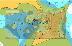
The accompanying image shows the electronic chart of Musket Cove overlaid with a Google Maps satellite photograph. Notice that while the land is represented accurately on the chart, the reefs are only marginally accurate, particularly in the center, where my anchor position is marked on a green reef. In actuality, we were anchored in more than 40 feet of water in the center between the two reefs as shown by Google. In this case, Google is the more accurate position source.
Useful techniques
For this example, go to Google Maps and use only the satellite image mode. You can change from street maps to satellite images with an icon in the lower left corner of the Google Maps window.
 |
|
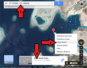
The red arrows show the location of controls used in Google Maps. |
If you already have a waypoint or latitude/longitude information from a chart or chartplotter and want to see it in Google Maps, enter the coordinates directly into the Google Maps search box (No. 1 in the screenshot on the next page). Google Maps is quite forgiving about the format for input. A decimal-degrees input is shown, but you can use degrees-minutes and put in a space for the degrees symbol — for example, “17 46.623s 177 11.038e” — and Maps takes you to that location and puts a marker there.
To find the true position of a feature you see in Google Maps (such as a reef), put your cursor on the feature, right click and select “What’s Here?” (No. 2 in the screenshot). A pop-up will appear showing the coordinates (No. 3): -17.772412, 177.186565
Google Maps displays a decimal-degrees system rather than degrees-minutes, and uses minus signs to indicate the Southern or Western Hemispheres. Conversion to degrees-minutes positions is pretty straightforward. To get the minutes, take the decimal part of the coordinate and multiply it by 60.
0.772412 × 60 = 46.34472 and
0.186565 × 60 = 11.19390
So the latitude/longitude is: 17° 46.345’ S 177° 11.194’ E
These coordinates can be keyed into a chartplotter or plotted on a paper chart.
Tip: If you click on the coordinates in the pop-up, Google Maps will center on that position and the coordinates will appear in the search box. You can copy/paste from there to your calculator app. Google Maps also does a conversion to latitude/longitude, but it is converted to degree-minutes-seconds, which most chartplotters won’t accept.
 |
|
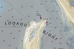
Google Maps overlaid on chart at Lookout Bight. Chart indicates 28 feet of water SW of R“4” but map shows dry land. |
Plan ahead
When you most need the Google Maps data, you probably won’t have Internet access. Before starting a passage, go to Google Maps and save the information you need about your destination. An easy way (in a Windows operating system) is to use your browser to display the map you want to save, then press Alt-PrSc (“Print Screen”). This copies the map data from your browser to the clipboard. Open your favorite image program, and paste the image in. We paste images directly into our word-processing app because it handles images well and we can easily add notes. You can make the images small in the word processor and still zoom in when you need more detail. If you’re using a Mac operating system, press Command-Shift-3, which copies the screenshot to the desktop. For those using an iPad, press the Home and Sleep/Wake buttons simultaneously and the screenshot is captured to the camera roll.
Keep in mind that even though Google Maps can show you the locations of dangers, it doesn’t have depth information and it can never show you safe locations. Always check your chart to see water depths.
Experience examples
When entering Port Resolution on the island of Tanna (Vanuatu), the charts are sketchy on the location of rocks off the point that you must round to enter the bay. But Google Maps shows the extent of the rocks because the breakers you’ll need to avoid are clearly visible. In some areas, the Google images will be at high tide and/or on a calm day and might not be as useful as the examples here.
Closer to home, Lookout Bight is a popular anchorage between Cape Hatteras and Beaufort, N.C. The sandbar protecting the anchorage has grown significantly since the nautical chart was made and the growth is clearly visible on Google Maps. The sandbar is significant enough that a chart-based route from the southwest will put you on dry land as you approach marker R“4.”
All in all, when you’re navigating in areas of marginal nautical charts, Google Maps is worth a look.
Charlie and Cathy Simon, circumnavigators, have sailed the U.S. coasts from Alaska to Nova Scotia. They live aboard their 2003 Taswell 58 Celebrate in Annapolis, Md. Their book QuickStart Circumnavigation Guide, is available from Amazon and at circumnavigationguide.com.