Peter Hejno had an epiphany when considering decorating options for his sailboat. Why not hang some framed nautical charts he had collected over the years?
He wasn’t happy with the finished product, which appeared static and flat in the frames. Through this process, however, he came up with a new idea to create 3D models using nautical charts.
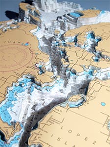
“I wanted to bring them alive, so I started to experiment with the depth of the nautical charts,” Hejno, 36, recalled in a recent phone interview from Alameda, Calif., where he and his partner live aboard their Beneteau 361 Bohemia.
Over the last two years, he has created more than 150 artworks under the business Neptune Maps. Each piece uses multiple charts that are carefully cut using precision tools. Cut sections are then glued onto architectural foam to match the chart’s exact contours. Some intricate pieces require up to nine layers of foam with paper from a half-dozen charts.
The finished products are mounted in a frame and can be customized with LED lights and other features to highlight the depths.
This type of artwork requires patience and attention to detail. Finished pieces generally take between 10 and 40 hours, depending on the size and chart location. San Francisco Bay, for instance, takes substantially less time than the San Juan Islands.
“Certain charts I don’t want to see in my entire life ever again, the Bahamas being one of them,” he quipped. “The more islands there are, the more difficult it is.”
Early sales were to sailors in California, and subsequent customers came through word of mouth. These days, roughly 80 percent of his customers are sailors, and often they choose charts with significance to them, either a home port or a memorable destination.
Lately, people with coastal homes also have bought 3D charts highlighting where the homes are located. One notable piece showing Carmel Bay in Northern California hangs in a home once owned by the actress Kim Novak.
Hejno has been successful enough to make Neptune Maps his full-time job. Operating from a studio in Oakland, he usually has a handful of commissioned pieces underway at any given time. Although he generally uses NOAA charts because they’re so easily available, he can create pieces using charts from other countries as well.
“It’s all depending on what the client wants,” he said.
Hejno’s 3D maps come framed and are available in four sizes. Pricing starts at $249 for a 14-by-11-inch piece and runs up to $1,150 and up for the largest size, 36 inches by 27 inches. LED lights and other add-ons raise the cost.
The company website, neptunemaps.com, has more details and plenty of high-resolution images of past projects. It also has contact information for Hejno.