Editor’s note: Every voyager has different needs and tastes for the hardware on their boat. It’s no different with smartphone and tablet apps for voyaging. Here is a roundup of what these accomplished voyagers are using aboard their boats for voyaging from the South Pacific to the Arctic.
 |
From Rich Ian-Frese
Rich Ian-Frese and his wife Cat live aboard their Tayana 37 Anna and are currently in the South Pacific.
Weather
App: zyGrib OS: Windows, Mac OS X, Linux Cost: Free
zyGrib is a powerful GRIB file viewer. GRIBs can be requested by email and they are much richer in data than SailMail’s data files. The zyGrib viewer can be installed on Linux, Mac OS X and Windows systems. We have found zyGrib to be, by far, the most powerful and data-rich GRIB viewer.
Weather
App: Weather4D, Weather 4D Pro OS: iOS, Android Cost: Free/$33.99
Weather4D is another well-executed GRIB file viewer for when access to Wi-Fi is available. The apps are for Apple and Android systems, and while they are more fleshed out for Apple, the Android version is powerful and versatile enough. We use this on our Nexus 7 tablet.
 |
|
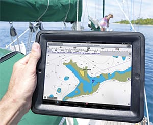
Bringing an electronic chart on deck is one of the advantages of using a tablet on board. |
|
Neville Hockley |
Navigation
App: Navionics OS: iOS, Android Cost: $10-$65
We use this on our Nexus 7 tablet as an alternative to OpenCPN on our PC. The Navionics charts for the South Pacific show good detail. We have used it reliably from South America through the South Pacific islands. Their accuracy is excellent. Not as good for plotting and editing routes as a traditional charting program, but for a convenient real-time tool it is rather appealing.
Weather planning
App: Windyty OS: Web-based Cost: Free
Windyty is a web-based application and is a great tool for looking at the big weather picture and seeing the flow and patterns on a more global scale before zooming in on the more localized level. Among other things, like wind, gust, rainfall, clouds, etc., by looking at the “rainfall accumulation over 10 days option” you can visualize the Intertropical Convergence Zone (ITCZ) and South Pacific Convergence Zone (SPCZ) and extra-SPCZ zones near the equator. This is handy and hard to see on normal GRIB files, or without IR sat imagery. Windyty is a very useful weather-planning tool.
 |
From Livia Gilstrap
Livia and her co-captain Carol Dupuis cruise aboard their 35-foot Wauquiez Pretorien Estrellita 5.10b.
Navigation/Charting
App: iNavX OS: iOS Cost: $24.99
iNavx navigation software with Navionics charts — some problems, but because we were set on having Navionics for the South Pacific, it was the best option.
Navigation/Charting
App: OvitalMap OS: iOS Cost: Free
App: MotionX GPS OS: iOS Cost: $1.99
We alternate between using OvitalMap and MotionX GPS for navigating with satellite imagery while sailing, but both cache for offline use poorly so in non-3G areas we supplement with SAS-Planet (PC only, but thoroughly caches for offline use).
Communications
App: Skype OS: iOS, Android, Windows, Mac OS X, Linux Cost: Free
For voyaging, local calls and calling home. We pay for a Skype phone number so we still have a U.S. phone number with voicemail.
 |
From David and Marcie Lynn
David Lynn and his wife, Marcie, have lived aboard their 45-foot 1986 Liberty cutter Nine of Cups since 2000.
Navigation/Charting
App: Navionics OS: iOS, Android Cost: $10-$65
What we consider to be minimal functionality in a navigation and charting app is the ability to show our position and course overlaid on a chart, enter waypoints and routes, and provide tracking information. Since we tend to travel off the beaten path quite a bit, we also require charts for different areas of the world, not necessarily just usual cruising routes. The Navionics app provides worldwide charts, has the basic functionality we need, plus a good tide table feature that is integrated seamlessly into the chart.
 |
|
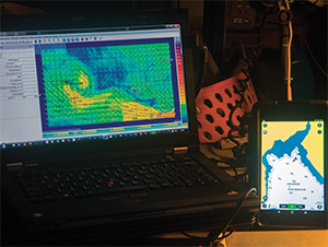
Rich and Cat Ian-Frese, on the Tayana 37, Anna, uses zyGrib on a laptop and Navionics charts on a phone. |
|
Rich Ian-Frese |
Anchor Alarm
App: Boat Sentry OS: iOS Cost: Free
We use an anchor alarm a lot, and most of the time, a very simple radius alarm is quite adequate. When we set the anchor, we also set a radius around the current GPS location of the boat. If we move outside that radius, the alarm goes off. For regular use, most chartplotters and hand-held marine GPSes provide this function and work quite well, although if a tight radius is set, they tend to result in frequent false alarms. Boat Sentry, however, has a number of features that we’ve come to appreciate:
• I can “drop the anchor” at the present position or at another location by entering its range and bearing from the present position.
• I can define a safe zone in any of several shapes — a circle, an arc or a pie shape, to name a few. Once the shape is defined, I can decide whether to center the shape on the current position, the position of the anchor or some other custom position.
• Finally, I can set the allowable drift in any direction – port, starboard, forward or aft. If the boat drifts outside the safe zone, the alarm sounds.
Local Maps
App: Maps.me OS: iOS, Android Cost: Free
Once we’ve arrived in a new port, it’s fun to explore and learn our way around. Having a local map on hand is important and we’ve come to rely on Maps.me (formerly known as Maps with Me) wherever we are. This app has detailed maps for any state in the U.S., as well as any country in the world. Each map is downloaded to the tablet or smartphone, and once downloaded it needs no Internet connection. We download all the maps we might need ahead of time while we have Internet. If your tablet has a GPS, Maps.me will also show your current position on the map. The app and all the maps are free.
 |
From Neville Hockley
Neville & Catherine Hockley voyage aboard their Cabo Rico 41 Dream Time.
Navigation
App: iNavX OS: iOS Cost: $24.99
We use iNavX daily on Dream Time for route planning and for active navigation. We’ve also connected our Garmin chartplotter and B&G network to a multi-plexor, which transmits NMEA data within a Wi-Fi signal to iNavX, displaying all info — speed, depth, wind, heading, water temp etc. — on our iPad. It’s a great tool not only for passagemaking but if we’re anchored in a serious blow we’re able to safely monitor the conditions and the boat’s position from the comfort of the cabin.
Weather
App: iGrib OS: iOS Cost: $5.99
We also use iGrib pre-passage to get a 10-day forecast of wind, pressure and precipitation.
Recreation
App: Harbor Master OS: iOS, Windows phone Cost: Free
And for fun, Harbor Master: A game where the user is responsible for docking multiple and an increasing number of chaotically captained vessels intent on collision.
 |
From Jess Lloyd-Mostyn
Jessica and James Lloyd-Mostyn live aboard their Crossbow 42, Adamastor with their daughter Rocket and son Indigo.
Navigation
App: Navionics OS: iOS, Android Cost: $10-$65
To be honest, we only have a couple that we use regularly. We currently have two iPhones and an iPad on board and use them regularly as part of our everyday cruising. The iPhone is particularly handy for holding in one hand while at the helm or on watch. It’s also great as an instant reference when you are down in the cabin on passage and wake during the night and want to check your position, course and speed. The iPad is lovely with its larger format and particularly good when we look at passage planning ahead of time.
 |
|
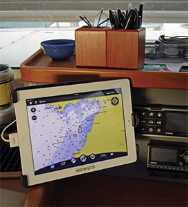
David and Marcie Lynn on Nine of Cups, make use of an iPad at the nav station. |
|
David and Marcie Lynn |
There’s a whole host of apps available but, to be honest, we only really use Navionics. We have iNavX and the Imray ones too, and we do like the feel and interface of these, as they help to add in some of the information in an easy format that our paper cruising guides contain.
I know that there are several more that focus on the U.K., U.S., Med and Caribbean, but we’ve only really used iPhones/iPads as an aid to navigation since the Caribbean and going through to the Pacific. It was quite amazing to us just how spot-on Navionics was in the most remote South Pacific islands. Of course, we have paper charts and cruising guides as well, but I always adopt a belt-and-braces approach to navigation. Ultimately, something as convenient as all your charts in a hand-held format like the iPhone does become invaluable when everyday cruising. Other tricky passes through reefs and places like that we would make sure that we had done a bit of reconnaissance, looking at the area on Google Earth/Google Maps satellite images when we had Wi-Fi access and then making sure to refer back to those images with our GPS “blue dot” turned on when we attempted the passes. But, of course, always in conjunction with going slowly and using our eyes more than anything else.
 |
From Eric Sanford
Eric Sanford and Debbie Lynn voyage on the 46-foot Leopard cruising cat named Indigo.
Navigation
App: Garmin BlueChart Mobile OS: iOS Cost: Free – $44.99
The very best chartplotter program I have found (everyone raves about it) is Garmin BlueChart. The app itself is free, and additional charts range from $29.99 to $44.99. It’s fast and easy and intuitive. I use it on an iPad. In fact, I bought a used iPad for $100 (make sure you are using at least an iPad 2 since it won’t run on an iPad 1) just to run this program as a second chartplotter on both my boats — an incredible deal. There is really no excuse why anyone would not use this system: a total of around $200 for a great chartplotter — with charts! And once you buy them you can easily download more for whatever region you are cruising in. Garmin hit it out of the park with this one.
Anchoring
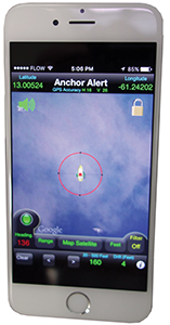
App: AnchorAlert OS: iOS, Android Cost: $3.99
The second app I use a lot is Anchor-Alert. It’s a pretty basic and simple-to-use anchor alarm program. It gives your current lat/long (I use it on my iPhone, which has a built-in GPS) and you can set it from 10 feet to 250 feet. As your boat drifts around, it constantly pings it and leaves a trail of little dots so you can actually see where your boat has been (no sneaking off to the dock to play with the other boats at night!). It also has a “color” button so you can use the screen in normal colors, darkened or red (for night vision) and the alarm is really loud.
Networking
App: RayView OS: iOS, Android Cost: Free
App: RayControl OS: iOS, Android Cost: Free
Since I have Raymarine MFDs on Indigo, I use a couple of their apps on my iPads. RayView lets me link up to my MFDs via a Wi-Fi connection and see what is going on. It’s a mirror of the chartplotter. RayControl lets me actually change things on my chartplotter — I can lay in my berth and virtually drive the boat. It works quite well and, best of all, if someone is sitting at the helm I can go below and mess with my iPad and really freak them out as the chartplotter and autopilot start doing things — “Uh Eric … you might want to come up here … something is going wacky with the autopilot!”
Instruments
App: Spyglass OS: iOS, Cost: $3.99
An honorable mention goes to Spyglass, which has a great compass and two-dimensional level (pitch and roll) as well as speedometer. Best of all, the compass also has a digital readout and works no matter what the orientation of your phone.
 |
From Robin Urquhart
Robin Urquhart and his partner, Fiona, live aboard their Dufour 35, Monark.
Navigation
App: Navionics OS: iOS, Android Cost: $10-$65
As our backup navigation system, we have used this app on our iPad for routing, double-checking and when our Raymarine chartplotter glitches out. It has been invaluable. Also Navionics is the most accurate charting for Mexico and made more so by Navionics cross-referencing the Mexican chart coordinates with Google Earth images. Still, we would love more soundings in some locations.
Anchoring
App: DragQueen OS: iOS, Android Cost: Free
The chartplotter is in the cockpit and we don’t like to keep it on when we’re at anchor as it is networked to the depth sounder and AIS. However, the iPad and Samsung rarely ever turn off. This app has been great for a free and relatively accurate anchor alarm. Just remember to turn it off when you leave the boat with your device, otherwise you’ll get an alarm about halfway to the beach.
Navigation
App: OpenCPN OS: Windows, Mac OS X Cost: Free
Like many cruisers, we are running OpenCPN on our laptop and Android phone as a backup chartplotter. Free NOAA charts work with OpenCPN and I’ve heard that there is a set of CM93 world charts that have been floating around the cruiser community that is commonly used on OpenCPN.
Weather
App: SailGrib OS: Android Cost: Free
Good GRIB weather app. It’s nice for storing GRIBs offline and checking later when we no longer have cell connection. Interface is a bit glitchy on the zoom, but the data is quick.
 |
|
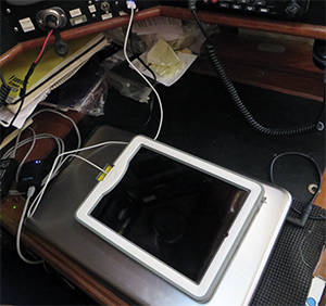
Eric Sanford, on the Leopard 46 Indigo, mounts an iPad with a holder at the nav station. |
|
Eric Sanford |
Navigation
App: RayControl OS: iOS, Android Cost: Free
This has worked really well. We do our route planning belowdecks on the iPad and then upload it to the chartplotter via the app. Also, the iPad works as a repeater screen with the app, so we can see the chartplotter and all its information no matter where we are on the boat. It works well, but because we have Navionics for iPad we usually use that instead of using the iPad as a repeater for the chartplotter.
Weather
App: Weather Station OS: Android Cost: Free
Samsung phones have built-in sensors to detect temperature, humidity and barometric pressure. As a backup system to tell us about the weather, we find it is as accurate as the Maretron and I even used to use it as a building science engineer for diagnosing issues in buildings — it’s that accurate.
Weather
App: Passage Weather OS: Web-based Cost: Free
It’s not an app, but it is probably the website we check most often. It should have its own app, but the website requires so little data that it works just fine as is. We have found Passage Weather more useful than Windyty because of its quick download time compared to Windyty, which lags on a slow connection.
 |
From Ellen Massey Leonard
Ellen Massey Leonard and Seth Leonard sail on their 40-foot sloop Celeste.
Communications
App: OCENS OneMail OS: iOS, Android Cost: $20
My most-used app on land is always Gmail — it’s how I stay in touch with absolutely everyone. So OneMail is my most-used app on the boat. It’s essentially Gmail for satellite connections, but it’s even better than that. It takes the “From,” subject and (most important) size of each message waiting for you in your Gmail account and downloads only that. Then it auto-disconnects (so you’re not wasting airtime) and you pick which messages you’d like to download and read. You tap those and hit “Connect” again, and it compresses, encrypts (for security) and downloads only those messages before auto-disconnecting again. Once you’ve read your mail and written your replies, you connect again to send your (compressed) replies. It even auto-compresses any photos you’d like to send — you don’t have to resize them yourself before sending. They still look good, too — they’re the same resolution as the photos I post on my blog.
Another great feature of OneMail is that it does not remove messages from your Gmail account. When you return to Wi-Fi and check Gmail, they’re all still there. The ones you read in OneMail will show up as having already been read. I find the interface very clean. It’s simple and straightforward to set up and use. I think it may start to replace my OCENS email account on my laptop, though I’ll keep that going a little longer since I like typing bigger messages on my computer.
Entertainment
App: Amazon Prime Music OS: iOS, Android Cost: Free, with Amazon Prime subscription
Since we got a Prime account, I’ve gotten addicted to all the “free” music you can download in the Prime app. I like listening to music on watch (when it’s smooth sailing) and we like playing music on the boat’s speakers at anchor. Previously we used a dedicated MP3 player, but now we have more music in the Prime app. You can search for a specific album or artist or for a genre. Once you’ve found something you like, you can download it so that it will appear in your offline library — very important for the boat! Then you can play it offshore when you’re far from any Internet connections. Amazon also recommends music based on your downloads and I’ve discovered music I didn’t know about that way, which has been fun. I find the interface easy to use and I like that the background is black so I don’t lose my night vision when picking new music on watch.
 |
|
Anchor Alert running on an iPhone. |
Navigation
App: Google Maps OS: Windows, Mac OS X Cost: Free
Google Maps is great for getting around an unfamiliar area. For example, we’ve spent a bit of time in Anchorage on our way to and from the boat the last couple of summers and Google Maps running on AT&T data is how we find everything from West Marine to the grocery store. We also used it in Nome (of all places!) to get an idea of decent dirt roads to bicycle on and explore the tundra outside town.
Communications
App: Skype OS: iOS, Android, Windows, Mac OS X, Linux Cost: Free
Obviously both Google Maps and Skype need Wi-Fi, so I don’t use them on passages or remote anchorages. Skype is a great free way to stay in touch with family far away.
It might seem strange that I don’t list any navigation or weather apps. I like the idea of some of the nav apps but they would still be backups for me. I don’t have a tablet, which I think would be a more convenient item for those apps, and my phone is definitely not waterproof, so the Raymarine touchscreen chartplotter wins out. It’s mounted on a little swinging door just inside the companionway and has all the charts I’ve bought on it. It’s also integrated with my autopilot and radar. Furthermore, I only use that when I’m coming into an anchorage/port. On passage we’re misers about power and still use an old Furuno GP32 — the little black-and-white GPS unit — with paper charts. It only uses 0.1 amp and I like plotting courses and positions and comparing them with our compass course, etc. It gives some interest to the navigation and keeps me in practice with my triangles and dividers.
Weather
App: OCENS WeatherNet OS: Windows, Mac OS X Cost: $99
We’ve found OCENS WeatherNet very reliable over this Arctic voyage. Plus I like looking at GRIBs on a bigger screen. So again, maybe I’d be more likely to use a weather app if I had a tablet. I’m not sure, though; I wouldn’t want to pay for another service when I already have WeatherNet.
 |
From Dick Stevenson
Dick and Ginger Stevenson live aboard their Valiant 42, Alchemy.
Navigation
App: Navionics OS: iOS, Android Cost: $10-$65
We use the Navionics app less for serious navigation, but for casual planning and appreciate that its connectivity keeps it up to date.
Weather
App: PocketGrib OS: iOS, Android Cost: $5.99
PocketGrib is a fast, simple GRIB app that stays on your phone after leaving Internet connection. We can download weather info while walking through town or in marginal conditions and then check it later.
Weather
App: Windfinder OS: iOS, Android Cost: Free
Windfinder gives us weather data for a specific location. We use it mostly on our iPhone.