From the Ocean Navigator School of Seamanship weather course

A comma cloud system is really nothing more than a more descriptive name for a cyclone or low-pressure system. Learning to recognize the elements of the comma cloud will help voyagers when they’re studying satellite images and weather charts.
In general, a comma cloud is a deep mass of multilayered clouds that is often shaped 1ike a comma. It reflects a region of positive vorticity advection (PVA) and can vary in size from a few hundred miles (a clump of thunderstorms whose anvils combine in the shape of a comma) to more than 1,000 miles across (a mature mid-latitude cyclone). Regardless of the size of a comma cloud system, the comma shape is produced by cloud distortion due to rotation of the air around a centroid.
Comma clouds have the following common features:
- S-shape on back edge of comma. The back edge is normally well-defined and smooth. The front edge is normally ragged.
- Comma head. The wider cloud section located to the left of the maximum winds aloft in the area of strongest PVA. The comma head tends to lag somewhat and show the most tendency for rotation. Heaviest storm precipitation occurs under the comma head.
- Surge region. The dry air intrusion into the comma head. It’s located at the region of highest upper-level winds and tends to have fair to clear skies.
- Comma tail. The tail extends from the surge region of the head generally to the south or southwest. It parallels the axis of max upper-level winds. The tail cloud band lies along the low-level deformation zone — a band along which convergence and stretching occurs.
Mature comma cloud systems consist of distinct regions of cloudiness: 1) comma head and tail; 2) baroclinic zone cirrus; 3) deformation zone cirrus.
Comma cloud systems generate considerable precipitation and turbulence as one jet flow weakens and another intensifies. The section of the comma head called the surge region is where the entering jet undergoes considerable dissipation of kinetic energy. This results in moderate or greater turbulence and decreasing winds. Energy produced by the intensifying storm baroclinic zone goes into creating a new jet streak on the top of the comma head (the deformation zone cirrus region).
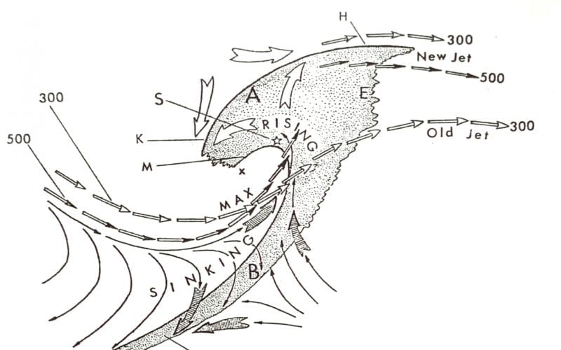
The accompanying drawing shows a model of a typical comma cloud system in the westerlies and its related wind field features. The model was empirically derived by comparing numerous comma systems on satellite imagery with surface and upper air data. The clouds involved with such a system, indicated by the shaded region on the drawing, are not all the same type or vertical distribution.
On the drawing, broad open arrows indicate axes of maximum winds at 300mb (open arrowheads) and at 500 mb (solid arrowheads). Thin lines with arrowheads are surface streamlines. Very large arrows at “A” and “B” indicate hyperbolic flow in the relative motion. The deformation zone at location “A” is in the upper-level flow where the air that has risen forms a distinct boundary with the upstream flow. Some of the rising air falls back with respect to the system motion and dissipates at “M”; other air accelerates downstream and dissipates its cloud elements at the axis of the upper-level ridge near “E.” On the downstream side of the comma “head,” two axes of maximum winds at 300 mb are shown. The mid and upper tropospheric air between those speed maxima is warming with time. This warming, which correlates with the amounts of clouds and precipitation at the upstream side of the comma head, reduces the baroclinity with the “old jet” and increases it at the “new jet.” This process causes the original downstream jet to weaken and dissipate with time and forms a new jet speed maximum to the north.
The cloud comma system in this model represents a storm in its development phase. A surface low-pressure center would be near position “S” and rapidly deepening. The wind fields at and above 700 mb would not likely have been a “closed” cyclonic circulation center, and the system would move rapidly.