[gtx_gallery]
We are now well into the 2021 hurricane season and are watching the evolution of tropical cyclones in the Atlantic and the Pacific. In the past I have used these newsletters to present some information about particularly memorable hurricanes, but this time let’s take a look at a system that, while impactful for some, has not been a historic system by any measure. This system was very slow to develop despite traveling over some rather warm ocean waters at times during the first part of its history. I will examine this system through a series of satellite images with comments on each.
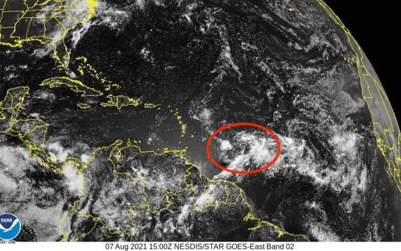
Tropical storm Fred began its life as a tropical wave in the central tropical Atlantic. The satellite photo in Figure 1 from 1500 UTC on August 7, 2021 shows the wave that would become Fred well to the east of the Windward Islands. This photo shows some clusters of showers and thundershowers without a great deal of organization, at least not the sort of organization generally expected with a tropical cyclone. There is no obvious rotary circulation, and it is difficult, even with a trained eye, to pick out a potential center of the system. What the photos do show is the general “waviness” of the flow in the tropical latitudes with another wave evident in the eastern tropical Atlantic well to the east of Fred.
24 hours later, Figure 2 shows the tropical wave having advanced to the west and showing a bit more organization with a more concentrated area of thunderstorms near the perceived center of the system. There is also more of a hint of some rotary circulation showing up in the cloud patterns.
Advancing another 24 hours, the system looks quite a bit more healthy in Figure 3 at 1500 UTC August 9, 2021. There is a larger area of more concentrated thunderstorm activity near a perceived center and some hint of some bands of showers. At this time, however, the system was still not classified as a tropical cyclone. While satellite images like this are powerful tools that were not available a couple of generations ago, there are other tools that are also used to determine if a system meets the criteria to be designated a tropical cyclone. A complete rotary circulation must be present at the surface, and convection (i.e. thunderstorms) must wrap all the way around the system. In the case of this wave, satellite observations of surface winds did not show that a complete rotary circulation was present, only a trough of low pressure with a wind shift line. Even though this system cannot be designated a tropical cyclone at this time, it can still produce heavy rains, intense thunderstorms and strong gusty winds.
A few years ago, the National Hurricane Center, realizing that there could be significant impacts from systems like these that are technically not tropical cyclones, began the practice of initiating advisories for “potential tropical cyclones.” This allows them to issue warnings with enough lead time for action to be taken when it is anticipated that a system will eventually become a tropical system, or when it will produce tropical cyclone-like conditions. This was done for this system later in the day on August 9, 2021.
Examining the image for the next day at 1500 UTC August 10, 2021, (Figure 4), it would not be unreasonable for most folks to assume that the system had become a tropical depression of even a tropical storm. However this was not the case. The system was still designated a potential tropical cyclone at this time. Reconnaissance aircraft (the “Hurricane Hunters”) were still not able to detect a fully closed circulation. This is despite the fact that satellite intensity-estimating algorithms that have been developed over the years would have classified the system as a tropical storm at this time. In this case, the actual observations taken by the aircraft trump the cloud patterns revealed by the satellite. It would be another 12 hours before the system was finally classified as a tropical cyclone, jumping right over the tropical depression classification and becoming Tropical Storm Fred.
Moving to Figure 5, the satellite image from 1500 UTC August 11, 2021, the system actually does not appear as robust as it did a day earlier, despite the fact that it is now a tropical storm with sustained winds of 40 knots. The red “X” shows the approximate location of the center of Fred’s circulation and reveals the issue. There were upper level winds from the west that were disrupting the vertical alignment of the system, and this has displaced most of the convection to the east of the center. This is commonly referred to as wind shear, and it can inhibit a tropical storm from strengthening, and even lead to weakening.
The shear continued through the following 24 hours, and the system also crossed the mountainous terrain of Hispaniola which disrupted the surface circulation. These factors led to weakening, and by 1500 UTC August 12, 2021 (Figure 6) Fred had been downgraded to a tropical depression. Note that the center of the system is in a region with very little significant convection with most of the convection well off to the east due to the shear.
Conditions would continue to be hostile for Fred for the following couple of days due to the shear and interaction with the mountainous terrain of Cuba. In fact, a couple of days later at 1500 UTC Saturday August 14, 2021 (Figure 7), the system would lose its surface circulation, and thus its classification as a tropical depression. The remnants of Fred would then move northwest into the eastern Gulf of Mexico and eventually become stronger and better organized again on Sunday August 15, 2021 and once again be classified as a tropical storm. It would eventually make landfall in the Florida panhandle as a robust tropical storm on Monday afternoon August 16, 2021.
The point of this narrative is that there are many factors determining how strong a tropical cyclone will be. Despite high oceanic heat content along much of the track of Fred, slow organization of the surface circulation, interaction with land, and upper level shear along with some entrainment of dry air into the circulation at times did not allow significant strengthening through the first week of its existence.
One final note, looking again at Figure 7: one can see Tropical Storm Grace to the east approaching the Lesser Antilles. This system also encountered upper level wind shear in the following days as it tracked through the northeastern Caribbean, and it also weakened into a depression. Even as a depression, it produced large amounts of rain over Hispaniola, including Haiti, which was dealing with a devastating earthquake just a few days prior to Grace’s arrival. The final chapter on Grace has yet to be written as this newsletter is being put to bed. It may end up being a fairly strong tropical storm approaching the Yucatan peninsula and/or the southern Gulf of Mexico, perhaps even a hurricane.
Ken McKinley is an ON contributing editor and is a weather router and owner of Locus Weather based in Camden, Maine.