To the editor: At the end of May 2011, the 10th month of refitting our Mason 44 Frances B for bluewater cruising, the north Florida air turned to steam. With teak overlay on the deck, our cabin temperatures soared to over 100° F and sweat soaked our bunk. Low pressure dimples in the mid tropical Atlantic began to swirl now and then, though still far enough away. We threw down the tools, pulled out the Canadian charts left from our previous trips and cast off. I promised we wouldn’t stop till we saw some ice.
Eighteen days later more ice than we ever hoped for stretched across our bow. The cliffs, pinnacles, turrets and summits towered over flat tabular ice islands resembling Antarctica’s ice on a much smaller scale. We were right in the remains of the giant ice island that calved off Greenland’s Petermann Glacier in 2010. It took all this ice a year to get south to the Strait of Belle Isle.
 |
|
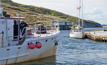
Frances B waits out the remains of Hurricane Irene at the Punchbowl with a few Newfoundland fishing vessels. |
Since 1992, the year the cod fisheries were stopped because of the collapse of fish stocks, the Labrador coast has been returning to pure nature. The buildings and old boats once crowding dozens of small bays along the outer coasts are slowly vanishing among the rocks and summer grasses. The old fishermen of Battle Harbour and their descendants rebuilt the settlement to its original glory, with fish sheds, old boats and cod drying stages included. Tourists are guided through the workings of the hamlet by volunteers who grew up here. One guide’s old country (Dorset in the U.K.) brogue baffled us, especially the references to “oish,” until he pointed to an old photograph of Battle Harbour filled by heavy ice growlers, the stuff we had to slalom through two days earlier. Now, however, Frances B rested tied to the wharf with electricity and water.
North of Red Bay village the Labrador coast becomes a network of channels amid numerous islands and long sounds leading far inland. When the cod fisheries boomed, the outer islands resounded with crews working in the nooks on the edge of ocean near the fishing grounds. The Labrador vocabulary developed around these activities. The schooners from Newfoundland brought their own workers promptly named “floaters” to distinguish them from “livyers,” people who chose to stay on the coast year around. Conflicts ensued when the floaters tried to poach fish from livyers’ traps. Richard Morris, born into a family of livyers established in Partridge Harbour, as a youngster spent summers fishing on Seal Island. Some Newfoundlanders repeatedly stole salmon from his father’s “berth” of nets. The dad loaded his shotgun cartridges with partridge berries and stayed out one night. He let fly at the arriving poachers who, taking the vivid red juice of the berries for blood pouring from their “wounds,” fled never to return.
South of the tree line the Labrador coast was green with blankets of grasses and crawling berry bushes. We were admiring the copses of forest in Squosho Run on the west side of Hawk Island when a skiff raced towards us. Stanley Campbell had a pioneer “livyer” piratical air about him relieved to a large extent by his English-Rose-pretty daughter; they zoomed up to give us two fish, still wiggling. No one lives farther north in the similarly protected but more remote Port Manvers Run. Here too the schoonermen of old left their mark in the names. We had to enter through the First Rattle where currents can really boil and then carried on through some “tickles,” narrow island flanked passages, to the Second Rattle.
 |
|
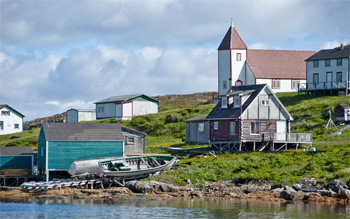
Battle Harbor, Labrador. |
The more challenging Labrador sailing begins after Hamilton Inlet which leads inland for 200 miles to Goose Bay. There are heaps of rocks generously scattered in unsurveyed waters on both sides of a belt of soundings marked on charts “track usually followed.” Precipitous brooding headlands like Cape Harrison reach into the Labrador Sea; North Atlantic-sized swells exploding against these unyielding bastions of stone. Currents flow fast and bring birds to plankton rich waters — fulmars, gannets, terns, diving razorbills and puffins. After Cape Harrigan we ran inland to the tickles weaving among countless islands. Populated mostly by Labrador’s indigenous people, the town of Nain, the last settlement on this coast, flashed by as Frances B charged by in a muscular southeast breeze. It was a fair wind and we were in a hurry as the short sailing season for smaller vessels in Labrador ends with the last days of August. Days later we drifted under the towering monumental bare rock walls of Mugford Tickle.
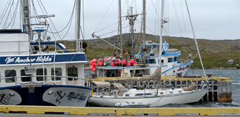
All summer up there we watched tropical storms barreling north and then banking eastward along the coast of Newfoundland. We thought we had escaped from all that hurricane business. Until Aug. 29, when all doubt vanished that the remains of Hurricane Irene would go right over us. Tied to the sturdy wharves of Punchbowl, an abandoned fish processing port, we had company. Leaving their gear catching turbot offshore, four long liners from Newfoundland sought shelter here, too. The hurricane party continued as the wind swerved from the south to northwest, whistling and hooting and holding Frances B over at a good angle for some hours. After the first week of September the winds farther north began their autumnal shrieking, but we were already tracking south towards Bonne Bay in Newfoundland and, later, to a relatively balmy fall in Nova Scotia.
————
Tom Zydler worked as captain on a 94-foot expedition yacht during a four-year voyage between Antarctica, Alaska/Aleutians, Japan, Philippines to Papua New Guinea, Indonesia, Thailand, Indian Ocean, South Africa and West Africa to the Med. He now sails with his wife Nancy on their Mason 44 Frances B.