Anna, our Tayana 37 cutter, was halfway to Easter Island, the westernmost outpost of Chile, before we realized that our voyage had run afoul of an unexpected weather situation. The original plan had been to lay a course of 180 degrees true for 31 days and sail 3,100 nm. This route would have taken us directly from the Galapagos to Chilean Patagonia.
After 40 days and nights at sea, however, we had arrived at Hiva Oa in French Polynesia — bearing 270 degrees true. This was more than 5,000 miles away from our original destination. How did we manage to stray so far?
The South Pacific high-pressure zone had turned out to be a formidable barrier. The high had been uncooperative, stubborn and pesky, but more importantly it was out of place according to the historical data.
For Anna to make progress in a southerly direction after departing the Galapagos, the wind direction needed to favor the southeast quadrant (i.e., east to east-southeast to southeast). And that is what normally happens in the month of December off the west coast of South America, where we began our passage to southern Chile. But this year was an anomaly.
True, a strong El Nino event can have a significant impact on wind direction, strength and currents, but we don’t believe that El Nino was responsible for the shift in wind direction over the Southeast Pacific Ocean since, according to NOAA, it was questionable as to whether or not El Nino had even developed yet. It was still early December 2014, and the prognosis was leaning toward a weak to neutral southern oscillation. We believe that the anomaly was simply a glitch — a snafu that had occurred, coincidentally, at the time that we were en route near 11° S, 100° W.
Technically, a persistent strong high-pressure system was centered over 30° S, 110° W, and this had the effect of shifting the wind in our general ocean neighborhood toward SSE, essentially heading us to the southwest and well away from our intended course. In fact, we had migrated far enough away from our intended course to land us at either Pitcairn Island or the Gambiers in southeastern Polynesia, thousands of miles out of our way. What to do?
 |
|
Cat Ian-Frese inspects one of the numerous flying fish that found their way aboard Anna. |
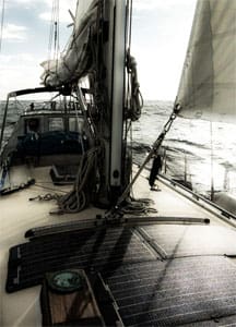
We had been beating hard-to weather for 10 straight days, shortly after departing the Galapagos. The Southeast trade winds were reinforced and averaged more than 25 knots just off our port bow. The seas were confused by a cross-swell in addition to the short-period wind waves we were experiencing, and their height was in the neighborhood of 10 to 12 feet on average. Anna happens to go well to weather, but we were only 1,000 nm into a 4,000-nm passage, and the forecast GRIB files promised conditions to deteriorate with higher winds and bigger seas — both from an unfavorable direction for at least the next week.
Moving well but in wrong direction
We were moving well but not in the correct direction — not unless we were agreeable to reaching Patagonia after a 6,000-nm ride. It was a route that would take us out just west of the Gambiers and then double back to ride the 40th parallel to southern Chile — a tight beat to weather for the first third of the passage. Then some downwind work in unstable air near the edge of the cyclone zone, followed 1,000 miles later by erratic wind and waves, which might arise from any quarter and at any time — sprinkled with short but intense squalls for the last third of the ride and confused seas to match.
Anna was taking a beating and so were we, but she’s tough and could take it. We, on the other hand, thought the time had probably come to take a right turn and continue on downwind for a while. Our heads were spinning (no kidding!) and calming life down a bit sounded like just the ticket — ease the sheets and re-group. We were at a crossroads at the intersection of “no” and “where,” at least 2,500 nm from anywhere that we could actually land, drop the hook, take a walk and sort things out.
We had a new decision to make and logic told us that our new destination would be either the Gambier group in southeast Polynesia, or the Marquesas Islands in northeast Polynesia. At the time, the Gambiers had been experiencing very unstable weather conditions due to their proximity to the South Pacific Convergence Zone (SPCZ). The SPCZ was sending heavy rain and squalls toward the Gambiers, along with remnants of tropical storms and cyclonic winds that had moved in from hot spots further west. The Marquesas, 15 degrees and 900 nm to the north and slightly west of the Gambiers, on the other hand, seemed more carefree.
 |
|
The plan was to sail southwest from the Galapagos, through the eastern side of the Southeast Pacific High and then on to Chilean Patagonia. After tough upwind work and a self-steering gear failure, Rich and Cat Ian-Frese changed destinations to the Marquesas. |
|
Ocean Navigator Illustration |
It would be a longer distance to the Marquesas. Plus, the wind direction would be somewhat more difficult as it would be dead downwind and require occasional long gybes in shifting winds as opposed to a more efficient broad reach, which the Gambiers offered. However, compared to what we had been experiencing, it would be easy to make the Marquesas.
Losing the wind vane self-steering
That is, until our Monitor self-steering device lost its water paddle to the sea just before dark, and with more than 1,000 nautical miles to go. The prospect of hand-steering the remainder of the way, before we would arrive at Hiva Oa in French Polynesia, was daunting. It is said that stainless steel is great, until it isn’t — that is, until it catastrophically fails. We were shocked at how suddenly we lost this critical piece of gear.
A serious mechanical failure of a stainless-steel wind vane isn’t a common occurrence. We have used our Monitor self-steering device for 15 years and made multiple long-distance ocean crossings of the Pacific without incident. However, it should have been no surprise that stainless could, in fact, fail in mid-ocean. Stainless — even 316-grade steel — will corrode after prolonged exposure in the harshest environment on earth: the ocean. Hidden crevice corrosion had apparently occurred in the exterior portion of the stainless tube, which runs through the Monitor’s water paddle. It’s very hard to detect this type of crevice corrosion and actually do something about it in advance of its failure.
It is for this same reason that insurance companies require stainless rigging to be replaced at least every 10 years for an ocean-going yacht that is going to cross an ocean. Failure of the standing rigging is much more serious than a self-steering failure. Nonetheless, the mid-ocean loss of a self-steering device is no picnic.
In our case we were left with only two options: either hand-steer Anna 24/7 for the next 1,000 miles (i.e., nonstop, for days and days with only a crew of two), or jury-rig a system of bungee cords to help tweak the steering a bit by gently holding the wheel in place and keeping the boat, more or less, on track. To do this effectively, however, required that the sail plan be perfectly balanced. This is hard to do when sailing dead downwind in a cross swell with continual shifting winds and squalls. These elements wreak havoc with the course and require constant correction.
 |
|
Big silverbacked waves rolling through during Anna's downwind run to the Marquesas. |
We did manage to rig a balanced sail plan, although it did require less sail area up than we would normally have liked. We were tracking well (without having to hand-steer), but moving slowly (about 3 knots, sometimes less). Anna has a long keel and tracks very well downwind on her own if the sails are balanced. She is a forgiving boat and helped us out — making it possible for us to relax and sleep when we needed to, while she managed to steer a straight line under non-optimal conditions.
We had tried various sail configurations underway: mainsail (with first, second or third reef set) combined with a working staysail, or a storm staysail, or a Yankee jib or a code-zero drifter when conditions went light. To our surprise, we found that keeping a second reef in a centered main and sheeting it flat, in combination with a working staysail, also — and illogically — seemed to balance out the rig and track well. It was slow going, granted, and normally we would never sheet in a staysail or main, especially in light air when running dead down, but no other combination was as carefree and hands off.
With this sail plan we had no need to hand-steer at all, even with fluky variable winds and heavy sporadic gusting and confused seas. We never would have imagined this to work, and it was by accident that we had stumbled on to it. Anna even gybed herself in the shifty squalls when the wind suddenly backed and set her on a new course as she zigzagged her way west.
A shorter way to go
Of course, we had not intended to end up in French Polynesia. If we had, our route would have been much shorter. After all, no one intentionally heads in the direction of southern Chile for a better wind angle to French Polynesia. We would have followed the rhumb line WSW from the Galapagos to the Marquesas, an easy broad reach almost the entire way from about 5° S. And at the right time of year, say April instead of December, it would likely be a much faster ride with favorable, stronger currents to boost the speed. It could have taken us about half the time. But since our intended destination was southern Chile by the offshore route, we had gone much further south than would normally be required to lay the Marquesas. The result was a long, squally 40-day passage with unstable weather for at least half the ride. In fact, it would probably have taken less time to get to northern Patagonia if the South Pacific High had been even modestly cooperative.
 |
|
A rain squall obscures the south side of Hiva Oa. |
After almost six weeks at sea we were getting down on our stores of fresh fruit and vegetables — we had degenerated to eating popcorn and drinking Black Label whiskey by the time we finally pulled into Hiva Oa. When we arrived we were greeted by another sailor who stopped by to deliver a fresh baguette and a couple of ripe mangoes. He had seen Anna sail in with heavy algae and barnacle growth along her waterline — a sure sign of a sailing vessel that had just arrived from somewhere far away, and probably had nothing of interest left in her lockers to eat or drink.
The trees on Hiva Oa are filled with exotic fruit and the French, of course, take their cuisine seriously. It’s been a while since we’ve seen people walking around with fresh baguettes sticking out of their backpacks.
Counting flying fish
To help pass the time on our voyage from the Galapagos, we developed a morning ritual. This included recording data in the ship’s log, downloading weather info through our HAM radio set, walking the decks and inspecting the rigging, sails and general state of affairs after the night watch was over. And inevitably, scattered around the decks were flying fish that landed — to their great surprise and demise — on Anna’s topsides and couldn’t manage to make it back through the scuppers into the ocean. Our final count after 40 days was 211 flying fish. That’s quite a haul, and with very little effort we could have eaten a seemingly endless supply of fresh fish without ever dropping a line over the side.
In almost six weeks at sea we saw very little human activity outside of our little world on Anna. One morning, about a week into our passage and 800 miles south of the Galapagos, a bright orange helicopter, with two men in bright orange life vests flew toward us. They came from the south at great speed, flying low and directly for our mast. When they approached, just after dawn, we were busy reefing our mainsail. They circled us twice and waved hello and, as quickly as they appeared, they had banked hard to our port side and disappeared beyond the horizon. We tried to determine where they had come from or where they were going or what exactly they were doing, but it remained a mystery. It seemed to us that they had a fuel supply that would allow them to fly at least 1,000 miles. That would have meant a departure from Easter Island if they were coming from the south, en route for the Galapagos. Either that or they had a landing pad on a large ship somewhere closer. Either way, they were a long ways from home, just like us.
 |
|
Anna at rest, anchored at Hiva Oa. |
Few vessels in sight
Another week had passed before we saw another boat. This time it was a large commercial fishing boat about 25 nm away off our port bow and moving toward the north and east, about 1,500 nm offshore of Peru. They too disappeared over the horizon and behind the swells. About three weeks later, shortly after we lost our self-steering rudder, we spotted two more vessels about 20 nm away off our starboard bow. We tried to hail them on our VHF but had no response. Why would they be monitoring their radio with nothing but a vast disk of sparkling sapphire seas for as far as the eye could see? And that was the extent of our human sightings for the entire time we were underway.
As far as non-human life went, we saw a variety of sea birds out as far as 1,000 miles offshore. These included boobies, tropicbirds, petrels and frigates. But the bird that really took the prize for long-distance foraging was the small, unlikely papa-mosca, who never appeared to rest and could be spotted all by itself banking and swooping just atop the waves for thousands of miles across the sea. As we closed on land, dolphins glided in Anna’s wake, criss-crossing her bow endlessly and effortlessly.
Once again the tropic birds began to appear and then the others, in increasingly greater numbers as we got closer to the archipelago. They were curious to see us bobbing along and began to circle Anna before getting back to the serious business of fishing. Flying fish were in a class of their own. They didn’t start to appear until all the birds, with the exception of the papa-mosca, disappeared. The flying fish would suddenly emerge from the ocean and fly just over the spray of the waves. They could travel for 300 feet or more and even change direction mid-flight, darting randomly every which way. They resembled the patterns in particle accelerator imagery. They flew in massive silver glittering schools, day and night, and occasionally ended up taking a wrong turn and colliding with Anna, who took great pride in capturing them.
Hiva Oa appeared as a dark black blob on the radar — not unlike the target that appears when a heavy squall arrives — and then on the horizon at twilight on day 40. And as the morning continued to brighten, the landscape revealed its true nature. The Marquesas archipelago is spectacularly verdant. Hiva Oa, where we happened to land, is mountainous and sometimes shrouded in a low-lying, self-generated cloud bank. This may offer up rain showers that cool the land and turn it unfathomably green, lush and, occasionally, exotically steamy.
 |
|
One of the peaks surrounding the anchorage at Hiva Oa. |
Life isn’t hard to take in Polynesia. Maybe drifting radically off course while en route to chilly Chile and washing up on a small Polynesian island to complete more boat repairs in yet another exotic location wasn’t so bad after all! Southern Chile just moved to the back burner. We intend to sail through the Marquesas to explore the archipelago in more depth as soon as we finish repairing our self-steering device.
We will then continue on, past the Tuamotus’ coral atolls, to Tahiti and the Society Islands, 1,000 miles south and west of the Marquesas.
The Marquesas are on the eastern limits of the cyclone zone, which extends from Australia in the west, to halfway across the expanse of the southern Pacific Ocean. It’s rare to see a cyclone hit here, in the Marquesas — famous last words in the illogical world of ocean weather.
Rich and Cat Ian-Frese have been voyaging on Anna since 2000.