Solstice weather charts

Solstice weather charts

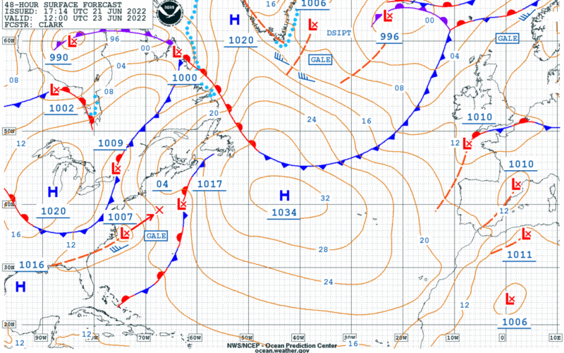
For this newsletter, I thought it might be a good idea to look at a few surface forecast charts and go through the features of the charts. This has been done before, but it is always good to have a refresher for this material, and there have been a few changes in the charts in recent years. Then I realized that we have just passed the summer solstice in the northern hemisphere, so it made sense to look at some charts produced on the summer solstice, and also to look back at the same charts produced on the winter solstice…
Read More
Newest GOES weather spacecraft

Newest GOES weather spacecraft

NOAA released a photo today from its latest Geostationary Operational Environmental Satellite (GOES), GOES-18. The image shows the Western Hemisphere from 22,236 miles out into space. GOES-18 was launched on March 1, 2022 from Cape Canaveral, Florida. This latest version of the GOES line has an Advanced Baseline Imager (ABI) instrument that can see Earth using 16 different channels, each measuring energy at different wavelengths along the electromagnetic spectrum. This allows the satellite to gather data about Earth’s atmosphere, land, and ocean. This is good news for voyagers, as better imagery translates into better marine forecasts. From the press release: "GOES-18…
Read More
Timing the tides

Timing the tides

Navigation is fundamentally about discovering the rules that govern nature. Unlocking these secrets is one of the most gratifying aspects of sailing; from observing the physics of weather to revealing our position relative to the celestial bodies. Another one of the most rewarding elements of navigation is understanding the tides. And tide considerations became central to the planning of a recent 60-nm passage I made in late summer of 2020 from the Great South Bay on Long Island to New York Harbor. Tides express themselves in two distinct but subtly interrelated ways: vertically through tidal height and horizontally through tidal currents.…
Read More
An obscure press release from NOAA on February 26, 2021, made an announcement about the availability of a chart in its catalog. Though the chart in question might never be used by ocean sailors, this release from NOAA was a big deal both for the history of US nautical charts and for their future. The announcement stated that as of August 2021, chart no. 18665 — the NOAA chart for land-locked Lake Tahoe, Calif. — would no longer be available in paper form from NOAA chart dealers. This first phase-out of a paper chart is part of a program that…
Read More