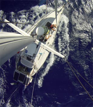
To the editor: It probably goes without saying that navigating around coral in areas without perfect charts and without good sunlight is a risky proposition. Depending on the season, the latitude and the direction you are traveling, the ideal time of day for visual navigation varies, but it is generally in the hours surrounding high noon. Coral heads and reefs are best seen when the sun is high and behind you, the sky is blue, and the water is clear and flat. All things being equal, we try to only move about in atolls in those conditions.
However, we have spent a fair portion of the last two years navigating in atolls in the South Pacific and there are numerous times when we have moved our cruising boat in a coral strewn lagoon in less than ideal lighting.
Why would we take that risk? Here are a few examples of what we felt were good reasons to navigate with bad lighting:
Unexpected squalls: We raise anchor in full sun and start out our navigation in ideal lighting conditions. Midway through our transit, squalls roll in, the rain starts, and our visibility is reduced to almost nothing.
Incoming weather: The wind is forecast to change and we are not protected from a direction. The anchorage will become unsafe by the next day and we want to move, but it is a cloudy, gray day and visibility is poor.
Large atolls: The atoll is large enough that we cannot transit from one anchorage to another in the ideal lighting hours.
 |
|
Livia Gilstrap |
|
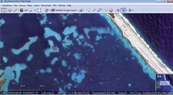
Using satellite imagery to mark reefs along a route inside an atoll's lagoon, allows Gilstrap to better visualize the path through the coral. |
Safe pass navigation times: The slack time at the pass we want to transit is such that in order to get to the pass for the slack we have to leave before or after the ideal lighting.
When these situations arise, we assess the relative danger of our options. In an anchorage, we have to decide whether it is safer to stay or to move. When underway, we have to decide whether it is safer to continue or turn around in the worsening visibility. Depending on the situation, we have a number of strategies for navigating around coral in less than ideal conditions.
First, there are the ways we keep an eye on the weather and the route while underway:
Keep track of safe areas when weather approaches: We keep an eye on the clouds and squalls while underway. When a squall approaches, we locate a safe area available to us to wait while the visibility is reduced. While underway in Penrhyn atoll in the Cook Islands we could see that a giant squall with heavy rain was going to overtake us. We found a large reef-free area and made a circle before the rain came. We knew that as long as we stayed inside of that circle we would not crash into any reefs.
Keep track of safe headings: If the area is relatively reef-free, we sometimes decide on a bearing that we consider safe to navigate for a short period of low visibility. For example, if I have excellent visibility and can see that the way ahead is clear, we might decide that as long as we don’t change course we can continue ahead in a certain reduced visibility for a certain amount of time. This is useful if a single cloud is passing overhead and we know we will regain good visibility shortly.
Assess your anchorage when you enter: When we are navigating in or out of anchorages, as we enter shallower water we are often in the most reef-laden portion of the trip. As we enter, I make a mental note of whether I think it would be possible to exit the anchorage without visibility. Although near the anchorage is often the most difficult area in which to navigate without visibility, the timing and lighting conditions at our exit from the anchorage are also where we have the most control. We can wait for a brief sun break, or at least some lightening of the sky, and then raise anchor and get underway quickly.
Wear polarized sunglasses: When the sun is shining brightly overhead, polarized glasses are still useful, but where they become really important is when the sunlight is spotty, absent, or low angle — huge difference. We use relatively cheap versions (e.g., Suncloud) and have been able to pick up good ones while voyaging (e.g., for $20 in the fishing section of a chandlery in Tahiti).
 |
|
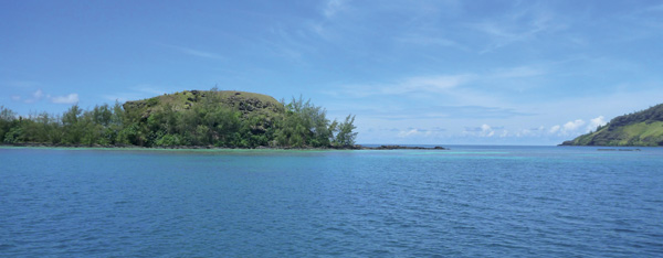
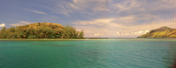
Above, an example of a coral strewn area in non-polarized light. Below, the same view in polarized light shows the coral and shallow areas more effectively. |
|
Livia Gilstrap |
Second, there are the ways that we use electronic charting:
High-resolution tracks: We are extremely careful about keeping our GPS tracks on multiple devices and backed up on various drives. We also make sure that the track that we keep is one that has been laid down with precision at high resolution. Many devices allow you to choose the resolution you are recording.
Recon in the anchorage: When we anchor, we take our dinghy and our hand-held GPS to nearby reefs, sound them with our hand-held depth sounder, and mark their positions. In this way, we have a clear electronic picture of the obstacles nearby in the shallower water where we have anchored. We can also take the dinghy along the route of our departure and mark obstacles before leaving with the big boat.
Marking reefs: While navigating, we mark the approximate location of reefs that we see. That way we know which side of our track to err on if we are following our track on a return trip. For example, if we saw a reef to the west of our track and nothing to the east of our track we can stay slightly east of our track in poor visibility. This also helps compensate for the plus-or-minus errors in the GPS location at the time you laid down your track. Remember that if you are +/- 16 feet, that means you are +/- 16 feet now and also might have been +/- 16 feet at the time of making the track.
Using satellite imagery: We usually mark the reefs, as described above, on satellite imagery which helps us better visualize our route. In addition, we use the satellite imagery before we set out to mark possible reefs. Although there is no substitute for a vigilant visual watch, we have been amazed at the number of reefs we can identify prior to weighing anchor with satellite images.
These strategies minimize, but do not eliminate, the risks we run in any navigation around coral, and the atolls we are visiting are often exceedingly remote. We have met cruisers who do not visit uncharted areas of atolls, or who avoid the dangers of atolls completely. However, the pleasures of isolated atolls are, for us, well worth the risk.
We are looking forward to many more years of dodging coral on our way to the bliss of a secluded anchorage near a coconut palm strewn motu — a tropical paradise all to ourselves.
————
Livia Gilstrap and her co-captain Carol cruise on their 35-foot Wauquiez Pretorien, Estrellita 5.10b. More at: thegiddyupplan.blogspot.com.