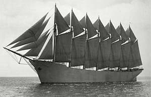
Imagine a 470-foot steel box. Then add seven 190-foot steel poles, Put sails on those poles — 25 in all, about 43,000 square feet — and then fill the box up with cargo. That sums up Thomas W. Lawson, the only seven-masted schooner ever built and the largest vessel powered only by the wind. The schooner, at 5,218 gross tons with a top speed of 16 knots, was the first sailing supertanker.
The idea of building a seven-masted schooner might seem like a good idea, but any schooner sailor knows that it presents some problems. One is sailing the vessel on the wind — unless the big sails are trimmed perfectly, they backwind and impede efficiency.
Lawson, named after an American copper baron, was designed by Bowdoin Crowninshield, who was renowned for his schooner designs.
It was built in 1902 at the Fore River Ship and Engine Co. in Quincy, Mass. When launched, Lawson was rigged with seven gaff sails, seven topsails, six staysails and five jibs. The naming of the masts started with numbering them 1 to 7. Then, they were called fore, main, mizzen, rusher, driver, jigger and spanker. Later, the crew called them by the days of the week.
Sails were raised by two steam winches and small electric winches. Lawson could carry almost 11,000 tons of coal using 1,000 tons of water ballast, with a crew of 18. The vessel was later chartered to carry case oil and then retrofitted to haul bulk oil from Texas to the East Coast. In November 1907, Lawson departed the Delaware River bound for England. It was a stormy season and the vessel lost most of its sails and all but one lifeboat. On Dec. 13, she dropped two anchors inside Bishop Rock to ride out a storm. The chains snapped, however, and Lawson was driven onto the rocks. All the sailors who had climbed into the rigging died when the masts collapsed. Local citizens tried heroically to rescue the crew, but only the captain and chief engineer survived. The resulting oil spill of more than 58,000 barrels of oil is considered to be the first large-scale maritime environmental disaster. The hull was rediscovered lying in 56 feet of water at 49° 53’ N by 06° 22’ W, and has become a favorite dive site.
Let’s join the ill-fated Captain Dow as he approaches the coast of England. He will be checking his latitude by use of a noon sight on Dec. 8. We will use the 2018 Nautical Almanac. Height of eye is 15 feet, and there is no known error on the sextant. The weather is cold and stormy with intermittent snow squalls. The skipper has been without a sight for a few days and he is grateful that the sky has cleared enough to get a glimpse of the sun. He reckons his DR at 48° 40’ N by 09° 6’ W. He is up on deck at around the time of local apparent noon (LAN). He will take a lower limb observation. We want to calculate the time of LAN. The Hs of the sun is recorded at 18° 36’. We want to calculate Ho, and then find latitude based on the closest hour in the Nautical Almanac for declination.
A. What is the time of LAN?
B. What is the Ho?
C. What is the latitude?
Answers
A. Time of LAN is 12:28
B. Ho is 18° 45.6’
C. Latitude is 48° 30.3’ N