Initially I thought I was being made the butt of a maritime joke. Steve Steinberg, the skipper of the 106-foot motor yacht Illiquid, was making a passage to Bermuda from Greenport, N.Y., and asked me to come along, ostensibly, to teach the crew celestial navigation.
Although I have sailed back and forth from Bermuda 25 times, mostly as navigator, sometimes as skipper, other times as crew, it has always been aboard vessels whose main source of propulsion was the wind. Schooners, sloops, ketches, yawls, trimarans — sailboats always, where quarters were cramped, fresh water rationed, and hot coffee constantly in short supply.
I had never made the trip aboard a high-end motor yacht. As it had been six years since I last crossed the Gulf Stream, I was yearning to go to sea and do what I love: navigate using my sextant. Who knew when the next opportunity might arise?
Since I was hired as “navigator,” I prepared as I would for any other passage. Using the Rude Star Finder and HO 249 Vol. I, the 2015 Epoch, I precalculated the stars for both evening and morning twilight times.
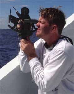
For two days prior to departure, I held three-hour classes for the crew. It was a lot to cover, but they were enthusiastic. I broke out my beautiful trusty Plath sextant; I also brought along a plastic Davis for the crew. The captain had a metal Frieberger.
In my kit when I boarded was a Celesticomp V calculator, copies of HO 249 Vol. 1 for selected stars, the 2015 Epoch, a copy of HO 249 Vol. 2, plotting paper, charting tools and the 2015 Nautical Almanac.
We departed Greenport after the effects of Hurricane Joaquin settled down offshore. Throughout the 52-hour passage the days were clear — perfect to get many sun sights.
I set my navigation workstation on the enclosed upper deck. I’m happy to say that after some initial fumbling, my sun lines fell right on the GPS positions.
One of the crew, Brian Welch, a young man out of Texas, had some previous experience and instantly took to sextant work. A few of his sights were more accurate than mine, and he was using the Davis sextant. We’ll use one of his sun shots below.
It is Oct. 8, 2015. We want to calculate the time of LAN based on course and speed. We’ll check the GPS to see how accurate the shot was.
We take a lower limb shot of the sun. The height of eye is 20 feet with no index error. From the time of our last fix and knowing our course of 143° True, we figure we will be around 69° W at the local mean time for noon. Based on that we go to the NA for Oct. 8 and see that Mer. Pass is at 1148 LMT. Based on our assumed longitude of 69° W, we add another four hours and 20 minutes or so to give us the time in GMT of roughly 1610. We begin taking our sights before that, and the sun reached its highest point with an Hs of 47°32’.
A. Find the Ho.
B. Once having found the Ho and using 1600 hour declination, find latitude. Plot.
C. At the time of the sight, the GPS recorded a fix of 36° 22’ N by 69° 10’ W. What is the EP from the plotted sun line?
Answers
A. Ho is 47°43.1’. For this sight I am dispensing with the .1’.
B. The latitude is 36° 21’ N.
C. The EP is the same as the GPS fix.