|
|
|
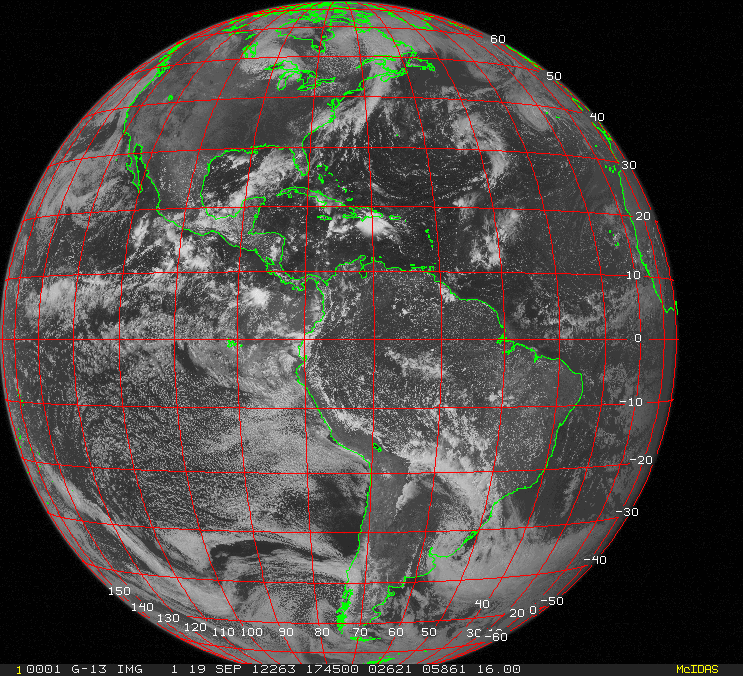
Figure 1 |
As I write this at the end of the baseball season, a season during which my favorite team, the Boston Red Sox, checked in with one of their worst won-loss records ever, in part attributed to many players being injured and the inability of the team to call in adequate replacements, it is apt to talk about the “team” of weather satellites in space. This team, too, suffered a debilitating injury in late September when imaging equipment on the satellite known as GOES-13 ceased to function properly. Thankfully, the team included a bench player ready to step right in, and after a delay of less than a day, GOES-14 was providing data that is critical to our observation of the atmosphere and the subsequent generation of weather forecasts.
The GOES satellites occupy geo-stationary orbits around the earth, which means they orbit the earth at the same speed at which the earth rotates. Therefore, they remain over the same position on the earth at an altitude of about 23,500 miles; these satellites can “see” an entire hemisphere of the earth at one time. The U.S. always has two operational GOES satellites in use, one which is positioned to observe the western U.S. and the eastern Pacific, and the other which is positioned to observe the eastern U.S. and the western Atlantic. Geo-stationary satellites are also operated by the European Union, Japan and Russia, and collectively, all of these satellites allow observation of the entire earth.
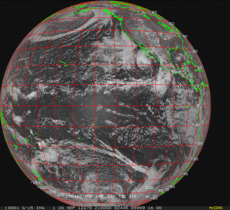
The accompanying figures show the different views of the U.S. GOES satellites. Figure 1 is a GOES-13 image, and that satellite was located over the equator at about 75° W. This image was taken on Sept. 19, 2012, less than a week before the satellite failed. Note that the satellite could observe much of the Atlantic, and at that time hurricane Nadine was located near the Azores and can be seen in the eastern portion of the image near 40° N / 30° W. Figure 2 is a GOES-15 image, and that satellite is located over the equator at about 135° W. This image was taken on Sept. 26, 2012, and shows an intense storm just south of Alaska as well as tropical storm Miriam southwest of the Baja peninsula.
 |
|
Figure 2 |
 |
|
Figure 3 |
Luckily, the U.S. keeps an extra satellite in a “parking” orbit in case of a problem with one of the operational spacecraft, and this satellite, GOES-14, was called into service when GOES-13 had its problem. Figure 3 shows an image from this satellite on Oct. 2, 2012. This satellite was parked at the equator near 105° W, roughly halfway between the two operational satellites, and this is clearly evident when comparing the images in Figure 1 and Figure 3. Nadine was actually still a tropical storm on Oct. 2, and was still in the vicinity of the Azores, but is barely visible on the eastern edge of the GOES-14 image in Figure 3. GOES-14 has begun to be moved eastward, but this is a slow process with its motion about 1° per day, so it will take about a month for this satellite to reach the operational position of 75° W.
GOES-13 is not considered to be dead at this point, and engineers are still able to communicate with the satellite. It is hoped that repairs will be able to be made to the instruments on board and allow it to eventually return to service. Of course, these fixes need to be done by remote commands since the satellite is in such a high orbit, well out of reach of any possible orbiting manned spacecraft.
The U.S. also has another satellite, GOES-12, which is located at the equator at about 60° W, and it is used primarily for providing imagery for South America, but also can observe the entire Atlantic and can be used for observing tropical cyclones. This is an older satellite, and its instrumentation is not as technologically advanced as that on the other spacecraft, and it also does not have any fuel remaining to adjust its position.
So, luckily for users of meteorological data, the satellite team had a game ready player ready to go when a proven performer went down. Hopefully the issues affecting GOES-13 can be rectified, and the spacecraft will become a valuable member of the team once again, because there are no more reserves waiting in the wings.
The Space Science and Engineering Center at the University of Wisconsin-Madison provides an excellent interface for viewing satellite images. Here is the link: http://www.ssec.wisc.edu/data/geo/