I had several clients who needed to move their charter vessels (both power and sail) from south Florida to the northeastern Caribbean in mid to late December of 2011. This passage is almost always an upwind passage due to the semi permanent presence of the Atlantic subtropical high which generally resides somewhere between 30 and 35 degrees north at this time of year.
Frequently during the period from early December through mid January or so, the easterly trade winds become stronger and remain moderately strong for a period of least several days, sometimes more than a week or so. These are the so-called “Christmas winds” of this region, and in mid to late December 2011 they were well established. This meant that my clients were facing stronger than normal headwinds over the waters east of the Bahamas and north of the Antilles with sustained wind speeds in the 25-30 knot range, and with these winds persisting for several days, the seas were able to build to 15 feet or more. Even to the south of Hispaniola and Puerto Rico in the northwestern Caribbean, the persistent strong easterly winds were able to produce much higher than normal seas.
For my clients, this meant a significant delay in getting their vessels to the Caribbean in time for holiday charters.
Let’s take a look at why these conditions frequently develop. As noted above, the Atlantic subtropical high (also known as the Bermuda High) plays the major role in this situation. This feature is present in the Atlantic almost all year, but its position shifts with the seasons, and its size and strength also varies. Typically, the high is larger and stronger during the summer months, but it is also usually centered at higher latitudes (in other words, farther north) at this time of year. During the transition from the warm season to the cold season, the “storm track” of lows progressing from North America generally eastward over the North Atlantic shifts farther south, and there is a corresponding shift southward of the subtropical high. Even though the high usually becomes smaller and weaker during this time of year, because it shifts farther south (usually to somewhere in the 25 to 30 degree north region) it induces a stronger pressure gradient between its higher pressure and the lower pressure farther south toward the equator. This increased pressure gradient leads to stronger winds.
Ironically enough, it is when the storm track becomes even more active with stronger systems and shifts farther south that the Christmas winds tend to abate. When strong lows move from the eastern U.S. into the western Atlantic and intensify farther to the south, it typically leads to weakening of the subtropical high with the center of the high shifting farther south, and farther east. In some cases, the high may disappear altogether for a short time, but more commonly, it just moves to the eastern Atlantic leaving the subtropical latitudes of the western Atlantic with no sign of any region of higher pressure. This will interrupt the trade wind flow and often lead to smaller seas in the waters north of the Caribbean Islands, although the other effect of a pattern like this can be large swells from the north eventually reaching the north facing shores of the islands because of strong northerly winds farther to the north behind strong winter storms.
This past December, the weather pattern featured a parade of storms tracking through the mid-Atlantic region east-northeast over the Atlantic. None of them became extraordinarily strong, and they all kept moving, meaning they did not stall. This pattern was ideal for suppressing the subtropical high to near 30N, and actually for keeping the high fairly strong, and the pattern persisted from early to mid December through just about Christmas Day.
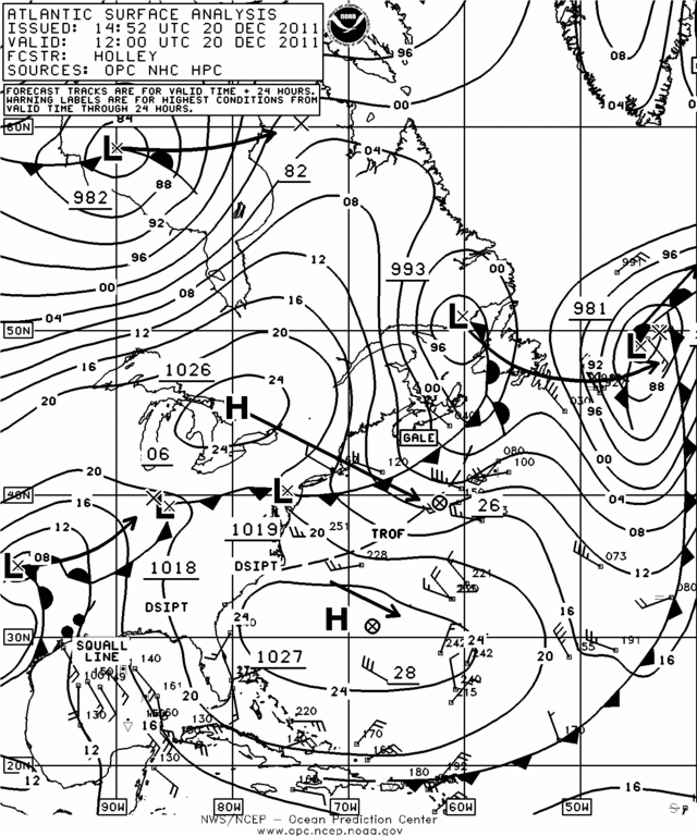
Figure 1 shows the surface weather pattern on Dec. 20, 2011, when the subtropical high was about at its strongest. Notice the center of the high just north of 30N, and the large area of moderately strong ENE winds to its south, right along a route from the Bahamas to the northeastern Caribbean. Notice also the tracks of lows to the ENE from the U.S. through the western Atlantic. As this pattern persisted, the seas built, and Figure 2 shows the resulting sea state analysis on Dec. 22.
Figure 3 shows the surface weather pattern on Christmas Day. Notice that the high has weakened to a ridge aligned along about 25N, with a frontal boundary having pushed south to near 30N, although another stronger high is located north of the front from the New England coastal waters to the Chesapeake region. This allowed the seas to subside by this time, shown in Figure 4, the sea state analysis for Christmas Day. Eventually, the new high settled south and winds and seas again became higher late in the month.
For ocean voyagers, it is best to have some flexibility whenever a passage from the southeastern U.S. to the Caribbean is contemplated late in the year. It will always be possible for the Christmas winds to make this passage very difficult, and sometimes the best choice will be to wait until the winds and seas ease; this could take many days, or even more than a week.