There was a time not that long ago when it was a novelty to see a voyager using a tablet or smartphone as an onboard tool. Now, of course, the reverse is true — it is rare to come across an offshore boat that doesn’t have a tablet (or two), loaded with half a dozen apps that are, well, if not indispensable, at least fun to use. When cruisers meet for sundowners in some remote anchorage, the conversation will almost surely include a conversation about the latest and greatest apps.
A few years ago, we bought a tablet and some basic navigation software to use as a backup for the cockpit chartplotter. Now we find it so essential that we have a second one to use as a backup for the original. We have downloaded dozens of apps, many of which, if not totally useless, were of very little value. We have found a few gems, however, and the following is a list of our favorite and most used apps.
Navigation and charting
 |
|
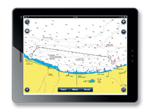
Navionics |
App: Navionics
Availability: iPad, iPhone, Android
Cost: $10 – $65
What we consider to be minimal functionality in a navigation and charting app is the ability to show our position and course overlaid on a chart, enter waypoints and routes, and provide tracking information. There are a host of apps that do this, and they fall into three categories: those that provide the charts for the coastal U.S., including lakes and rivers, those that provide the charts for major cruising areas like the Caribbean, Mediterranean, etc., and those that provide charts for almost any cruising area of the world.
 |
|
NV Charts |
For our needs, the choices are the Navionics and the iNavX apps, and it is a close call between them. Both provide charts for pretty much anywhere in the world, as well as the basic functionality we need. Both have their own pros and cons, and if you peruse the various forums, you will find any number of advocates for both apps. (Another charting app is the NV Charts app, available for iOS, Android and Windows.)
If your boat has one of the devices that converts NMEA data to a Wi-Fi signal, the iNavX has a clear advantage. One of its features allows it to collect NMEA data, such as wind speed and direction, depth, heading and AIS information, wirelessly from an onboard Wi-Fi hotspot, making your tablet or smartphone into a remote handheld chartplotter and instrument repeater. It has several other nice features including the ability to follow a route and provide the crosstrack error, and it has a good help function. The biggest downside with iNavX is that it is quite expensive by the time you purchase the app and the charts. Still, the price is far less expensive than buying a dedicated chartplotter and cockpit repeater with the associated charts.
The Navionics app has the basic functionality we need, plus a good tide table feature that is integrated seamlessly into the chart. While the cost of the app and the charts is quite high compared to most apps, it is still quite a bit less expensive than the iNavX app. In our opinion, the additional features don’t outweigh the cost difference, and our choice is the Navionics app. We don’t have the hardware that converts NMEA data to a Wi-Fi signal, but if we do add this capability, we will probably reconsider.
Anchor alarm
 |
|
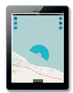
Boat Sentry |
App: Boat Sentry
Availability: iPad, iPhone
Cost: Free – $2.99
We use an anchor alarm a lot, and most of the time, a very simple radius alarm is quite adequate. When we are done anchoring, we set a radius around the current GPS location of the boat. If we move outside that radius, the alarm goes off. Most chartplotters and handheld marine GPS provide this function and work quite well.
Sometimes, however, a simple GPS type anchor alarm just isn’t adequate. Maybe we are on a lee shore with light winds predicted or are in an anchorage with limited swinging room. If the wind gods don’t get the memo from the weather bureau and do something unexpected, we could be in trouble. Setting a small radius on the anchor alarm will result in frequent false alarms. Setting a larger radius will reduce the time we have to react to a problem. The usual solution is a long sleepless night with one or both of us standing an anchor watch.
A few of the many anchor alarm apps solve this problem by allowing the user to define a “safe zone.” Boat Sentry is one we use and like. There is a free version, but it is pretty much useless except to get an idea of how it works, as it has a series of advertisements marching across the top of the display that obscure several of the operating icons. For $2.99, you can purchase the upgrade that not only gets rid of the ads, but also provides a reasonably accurate worldwide map.
Boat Sentry has a number of nice features:
• I can “drop the anchor” at the present position or at another location by entering its range and bearing from the present position.
• I can define a safe zone in any of several shapes, a circle, an arc, or a pie slice shape to name a few. Once the shape is defined, I can decide whether to center the shape on the current position, the position of the anchor or some other custom position. Finally, I can set the allowable drift in any direction — port, starboard, forward or aft. If the boat drifts outside the safe zone, the alarm is sounded.
In reality, having this app doesn’t allow either of us to sleep that much better when we are anchored on a lee shore, but it is still a nice app.
Range finder
 |
|
Range finder apps: EasyMeasure, SmartMeasure |
App: EasyMeasure, Smart Measure
Availability: iPad, Android
Cost: Free
Want to see how close you are to that rock or to the boat you are anchoring in front of? These are two clever apps (one for the iPad and one for Android devices) that use trigonometry and the camera lens to calculate the distance to an object. It is calibrated by entering the height of the camera lens above sea level. Then you line up the camera crosshair with the bottom of the object of interest. If the boat isn’t rolling too much and the object isn’t too far away, less than 300 feet or so, it is moderately accurate, and the price is certainly right.
Knots
 |
|
Animated knots by Grog |
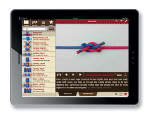
App: Animated Knots by Grog
Availability: iPad, iPhone, Android
Cost: $4.99
I really like knots and this is the best knot reference I know of. Not only is it comprehensive in the number of knots and splices it covers, but it provides a very detailed, step by step animated video that shows how to tie each one, as well as information about how and when each knot is used.
Want to tie a Prusik knot for climbing a halyard, or make a soft shackle for attaching your sheets to the jib, or maybe use a locked Brummel splice to secure your new Dyneema lifelines? They’re all there.
Star gazing
 |
|
StarMap 3D+ |
App: StarMap 3D+
Availability: iPad, iPhone
Cost: $2.99
For what might be the second best thing to do at night while anchored at an idyllic tropical island paradise, download this app, lie on the deck with your iPad and use it to identify all those stars, constellations and planets that seem close enough to touch. It uses the internal GPS, compass and the local time to figure out where, from your point of view, everything in the sky is oriented.
Local maps
 |
|
Maps with Me |
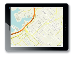
App: Maps with Me
Availability: iPad, iPhone, Android
Cost: Free; $4.99
So you’ve arrived in Mauritius (or Grand Turk, or Australia or Vanuatu), and after Quarantine, Customs, and Immigration have checked you in, you feel like taking a walk around town. Part of the fun of arriving in a new port is exploring and learning your way around, and usually it’s nice to have a map. Since you don’t have Internet access, you can’t pull up MapQuest or Google Maps. Maps with Me is an app that has maps for any state in the U.S., as well as any country in the world. Each map is downloaded to the tablet or smartphone, and once downloaded it needs no Internet connection. Download all the maps you might need ahead of time when you have an Internet connection and you are all set. If your tablet has a GPS, Maps with Me will also show your current position on the map. The app and all the maps are free. The Pro version adds more detail as well as some features like a search function and bookmarking.
Tides
 |
|
World Tides 2014 |
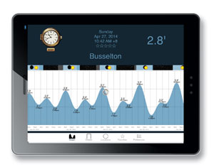
App: World Tides 2014
Availability: iPad, iPhone
Cost: $1.99
There are a lot of tide apps available, but most are limited to the U.S. or some other specific geographic region, and/or require an Internet connection. World Tides 2014, provides tidal data for more than 3,500 stations around the world, and does not require an Internet connection. It allows us to select the location using a worldwide map and provides the tidal data in either graphical or tabular form.
Provisioning
 |
|
Provisioning apps: Numbers, Google Drive |
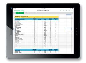
App: Numbers, Google Drive
Availability: iPad, iPhone, Android
Cost: 9.99/Free
Our wish list for a provisioning app is one that lets us enter all our consumables, the unit quantity, how much we use a week on average and the quantity on hand. Then we should be able to enter the number of weeks until the next provisioning opportunity and let the software figure out our buy list. That sounds simple, but we can’t find an app that allows us to do that. Most spreadsheet software can do just that, however, and that is how we generate our provisioning lists. Over the years, Marcie has put together a very complete list of consumables — everything from canned tomatoes to toothpaste. We originally used an Excel spreadsheet, but we have now imported it into Numbers, the spreadsheet app on our iPad. When it is time to provision, we update the onboard inventory, enter the number of weeks we plan to be out and generate the buy list. As we purchase an item, we update the quantity on hand.
Screen capture
App: Internal (iPad), Screenshot
Availability: iPad, iPhone, Android
Cost: Free
These are apps that capture and save the screen image. Before we leave Internet land and head off to some remote cruising area, we often use our iPad to capture web pages we might have use for later. For example, we often download the Google Earth image of potential anchorages. Then, using the screen capture app, we capture and save each image to a folder. Days or weeks later as we approach an anchorage, we can switch between the chart and the satellite view as we make our way in. The iPad has a built-in function for making a screen shot (hold the menu button down and press the on/off button momentarily). The Screenshot app is quite clever — once the image you want saved is on the screen, the app is started by giving your Android tablet a shake. The app allows you to annotate, crop or edit the image before saving it.
Communications
App: Skype
Availability: iPad, iPhone, Android
Cost: Free
Skype isn’t a new app and there are few cruisers who are not aware of it, but it has made such a big impact on the cruising life that it needs to be mentioned. When we first started cruising, making an international call home involved finding a pay phone, figuring out how to use it and inserting a pocketful of the local coins. Usually the connection was bad, often the phone booth would be located in the sweltering sun at the busiest, noisiest corner in town, and the call was always expensive. Now, as long as we can get an Internet connection, our Skype app gets us a better connection than we used to get with the local phone system, and is free or only pennies a minute. We’ve encouraged our family and friends to download it, too, so we can be in touch more often and without cost.
———
David and Marcie Lynn have lived aboard Nine of Cups, their 1986 Liberty 458 cutter since 2000. Since that time, they have sailed her over 70,000 nm in their ever-so-slow world circumnavigation and are currently cruising the west coast of Australia. Find them on their website at www.nineofcups.com or their daily blog at www.justalittlefurther.com.