
Low-pressure systems are the weather systems that produce most of the “bad” weather over the world’s oceans, meaning strongest winds and roughest seas. Some of these lows are tropical in nature (tropical storms and hurricanes) and while these systems can become quite intense, it is the non-tropical, or extratropical, lows that are more common, occur in all oceans and are typically larger, thus affecting greater areas.
As extratropical lows strengthen over ocean areas, warnings are issued for them. Gale warnings are issued when sustained winds are expected to exceed 34 knots and up through 47 knots. Storm warnings are issued for winds of 48 to 63 knots, and hurricane-force warnings are issued when sustained winds are anticipated to be 64 knots or more.
It is important to recognize that a hurricane-force warning is not the same as a hurricane warning, and a hurricane-force low is not a hurricane. The process of development and structure of a hurricane are fundamentally different than that of an extratropical low that produces hurricane-force winds. Extratropical lows develop along the boundaries between two different air masses while tropical systems develop within one air mass, and extratropical lows tend to be much larger than their tropical cousins.
When two air masses have a greater temperature contrast, often the extratropical lows that develop along the boundary between those air masses will become stronger than when the air masses are more similar in nature. Since much colder air masses are more common during the winter, this is when air mass contrasts will be greater. Because of this, hurricane-force lows are more common during this time of year.
 |
|
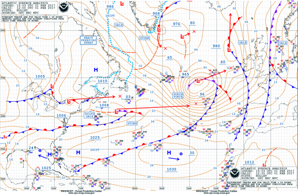
Fig. 1 |
In fact, by taking a look at a couple of recent surface weather charts for the North Atlantic and North Pacific Oceans, we can find hurricane-force lows in both oceans. In the Atlantic, the chart valid at 1200 GMT on Feb. 1, 2017 (Figure 1, above), shows a 965-mb low center near 49° N/27° W with a large circulation extending south to the Azores and from the central Atlantic east toward the British Isles. A surface chart from the Pacific valid at 0600 GMT on Feb. 6, 2017 (Figure 2, below), shows a strong low in the western Pacific to the east of Japan with the notation “Developing Hurricane Force.” This indicates that while the system is not currently producing hurricane-force winds, it is forecast to do so within 24 hours of the valid time of the chart.
 |
|
Fig. 2 |
This all leads up to a “Story Map” that has been produced by NOAA’s Ocean Prediction Center. This Story Map provides a wealth of information about the hurricane-force lows that were produced in the North Pacific during the winter of 2015-2016, and compares this season with other recent seasons. There is lots of information about hurricane-force lows, including satellite images and other graphics to help understand the topic. In fact, one of the systems examined in detail occurred in December of 2015 and was the focus of my newsletter sent at that time. I highly recommend taking the time to view this Story Map.
The link to the Story Map can also be found at the top of the Ocean Prediction Center’s home page at the time of this writing, and at later times will be found in the news archive, which is also accessible at the top of the home page. Note that the Story Map contains a large amount of data, so it may take more time to load than a typical webpage. There is a low-bandwidth version available for those with slower connections.