 |
|
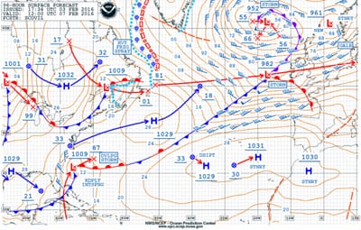
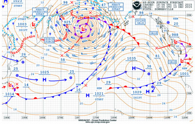
Figure 1: 96-hour surface forecast valid 1200 UTC Feb. 7, 2016. |
Once again a large ship encountered difficulties due to weather in February of 2016, and this was a major news story. This time it was a passenger ship, Royal Caribbean’s Anthem of the Seas. The ship encountered very strong winds and very high seas and suffered damage. Passengers were told to remain in their cabins for their safety as the ship endured the conditions. Thanks to the Internet and “viral videos,” the trials and tribulations of those on board were communicated nearly instantly around the world.
In this newsletter, I will examine the weather situation and try to answer the questions that are swirling about regarding this incident. Specifically, could the conditions have been anticipated? And, were the decisions that were made proper?
 |
|
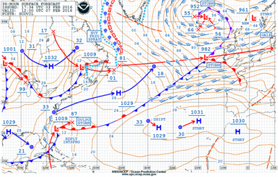
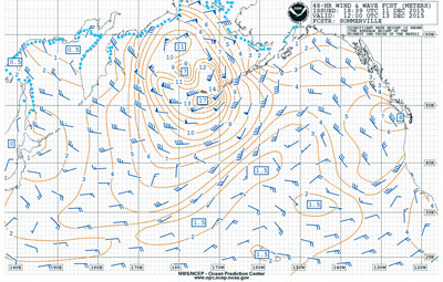
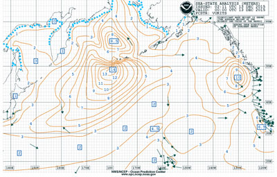
Figure 2: 96-hour wind & wave forecast valid 1200 UTC Feb. 7, 2016. |
The ship departed from New York Harbor on Saturday, Feb. 6, 2016, headed south along the coast toward the Bahamas. The conditions that caused the problems occurred about 36 hours later on Sunday night. We can start by examining forecast charts several days prior to the event. The 96-hour forecast produced on Feb. 3 and valid at 1200 UTC (0700 EST) on Sunday, Feb. 7 (Figure 1), shows a 1000-millibar low forecast to be centered off the southeastern U.S. coast. The low is forecast to move east-northeast and strengthen with its central pressure forecast to be 987 millibars 24 hours after the valid time of the chart. Winds are forecast to be generally from the north with sustained speeds of 35 knots at the valid time of the chart, but storm-force winds (48 to 63 knots) are shown as expected within 24 hours of that time. Examining the 96-hour wind and wave forecast chart valid at the same time (Figure 2), an area of 4-meter significant wave heights is indicated in connection with this system.
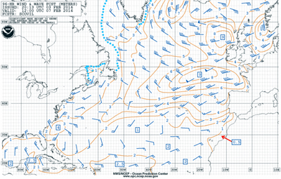
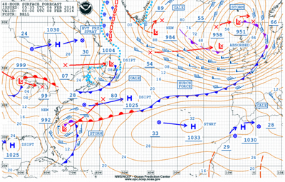
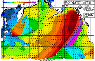
If we now move ahead to the forecast products that were available just prior to the ship’s departure from New York and examine the 48-hour surface forecast chart produced during the night of Feb. 5 and valid at 0000 UTC Feb. 8 (1900 EST Sunday evening Feb. 7, Figure 3), we find that the low is forecast to have a central pressure of 992 millibars and is forecast to be producing storm-force winds off the Carolina coast. The 48-hour wind and wave forecast chart valid at the same time (Figure 4) indicates significant wave heights of up to 6 meters (nearly 20 feet).
 |
|
Figure 3: 48-hour surface forecast valid 0000 UTC Feb. 8, 2016. |
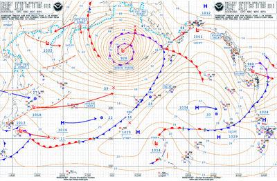
Pushing ahead another 24 hours, and looking at the 24-hour forecast that was available shortly after midnight (EST) Saturday night and valid at the same time as the 48-hour forecasts just examined (Figure 5), the low is now forecast to have a central pressure of 987 millibars and to be producing hurricane-force winds. In fact, note that the wind barbs west of the low center are indicating forecast sustained wind speeds of 65 knots. The corresponding wind and wave forecast (Figure 6) indicates maximum significant wave heights of 24 feet in this area.
The surface analysis chart valid at 0000 UTC Feb. 8 (Figure 7) shows that the actual central pressure of the low was 986 millibars and that it was producing hurricane-force winds. The wind/wave analysis chart (Figure 8) indicates that significant wave heights of 30 feet were present. This matches quite well with the 30-foot waves that Anthem of the Seas reported. Wind speeds reported from the ship were quite variable, anywhere from 100 to 150 mph. The weather buoys in the area reported gusts of more than 70 knots and, certainly given the weather situation, gusts of more than 100 mph (87 knots) were quite possible.
 |
|
Figure 4: 48-hour wind & wave forecast valid 0000 UTC Feb. 8, 2016. |
Now, some comments to help analyze the situation. First, wave heights are always given as significant wave heights, which are defined as the average of the highest third of all waves present. By definition, this means that there will be some higher waves present, and it has been found that in most cases the extreme wave can be as much as twice the significant wave height. Next, the ship was operating in or near the Gulf Stream and winds were against the current. In this situation, seas can build up to 50 percent higher than would otherwise be the case, and they will tend to be shorter and steeper as well. Often these localized conditions are not indicated on full ocean charts and must be inferred by the mariner when winds oppose the current.
 |
|
Figure 5: 24-hour surface forecast valid 0000 UTC Feb. 8, 2016. |
Looking at the collection of forecasts available in the days leading up to the event, it is not too difficult to determine that a significant system was forecast to impact the waters east of the Carolinas many days in advance. The 96-hour forecasts are valid prior to the start of the difficulty for the ship, but clearly indicate that the system is forecast to rapidly intensify through the period of interest. Comparing the 48- and 24-hour forecasts valid at 0000 UTC on Feb. 8 to the analysis showing what actually occurred, the forecasts — while imperfect — provided a very good picture of what would occur. For example, the 48-hour forecast predicted a central pressure of 992 millibars; the 24-hour forecast, 987 millibars; and the analysis showed that it ended up at 986 millibars. In addition, the position of the low center ended up about 120 nautical miles west-northwest of the position shown on the 48-hour forecast. The sea-state forecast at 48 hours predicted maximum significant wave heights of nearly 20 feet, the 24-hour forecast indicated maximum significant wave heights of 24 feet, and 30 feet actually occurred.
So, what could have been done differently?
 |
|
Figure 6: 24-hour wind & wave forecast valid 0000 UTC Feb. 8, 2016. |
The forecast information could have been interpreted more carefully. The forecast of significant wave heights of 20 feet on the 48-hour forecast (a full ocean chart) in the vicinity of the Gulf Stream when winds are forecast to oppose the current should be adjusted up to 50 percent higher, which would be 30 feet. Also, as noted above, waves will occasionally be higher than significant wave height due to its definition. This could have been determined prior to departure. Following the trend of the forecasts is also important. The forecast on the 24-hour forecast chart was for the low to be stronger, and the significant wave heights were forecast to be higher. Trends are important in forecast products, and in this case the trend was toward a stronger system with higher seas. This information would have been available to the ship before daybreak on Sunday.
 |
|
Figure 7: Surface analysis valid 0000 UTC Feb. 8, 2016. |
With the available information, the ship certainly could have made the decision not to move into the area where the incident occurred. This would have required delaying departure from New York or slowing down considerably to the north of Cape Hatteras, but the heavy weather forced the ship to slow down regardless and once they were able to resume sailing, they were a day behind their itinerary. Why not take that delay while safely in port, or in quieter conditions? As indicated on the forecast charts this system was expected to move rather quickly northeast away from the coast with conditions quickly improving.
To its credit, Royal Caribbean has made some changes in their operations following this incident. From its website: “Royal Caribbean … announced new plans to avoid storms like this with improved guidance.” Royal Caribbean “identified gaps” in its planning system and acknowledged, "what happened this week showed that we need to do better.”
 |
|
Figure 8: Wind and wave analysis valid 0000 UTC Feb. 8, 2016. |
Furthermore, Royal Caribbean announced it is strengthening its storm avoidance policy, and have added resources at their Miami headquarters to provide additional guidance to ships' captains.
Hopefully the company will follow through with their plans.
For all mariners, this is yet another lesson that plans and schedules, no matter how seemingly important, must all take a backseat to weather conditions for safety reasons.