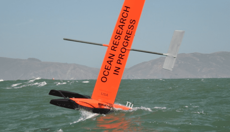
When you say drone, most people look up. A small firm in San Francisco called SailDrone wants people to look out to sea, too. On Oct. 1, 2013, the company's unmanned trimaran drone, dubbed SD1, departed Fan Francisco bound for Hawaii. Thirty four days later on November 4th, SD1 successfully completed the 2,100-mile passage, arriving in Kaneohe, Hawaii.
The 19-foot long, seven-foot wide autonomous vessel is propelled by a wing sail, can carry oceanographic sensors and has a payload capability of 220 pounds.
Saildrone's founders are Richard Jenkins and Dylan Owens. Jenkins is a mechanical engineer and holds the world speed record for wind powered vehicles at 126 mph, in a craft he designed and built, called the Ecotricity Greenbird. He's an avid sailor with more than 50,000 miles of ocean experience in a wide range of boats, power and sail. He holds a Private Pilot certificate and is seaplane rated.
Owens is a mechanical engineer with considerable experience in underwater robotics and electronics. After graduating from MIT, he worked on a number of projects for the Office of Naval Research and also on his own remotely controlled underwater robot, Rex, that completed extensive missions in the waters around Hawaii.
After the successful transpacific passage to Hawaii, SD1 departed the islands and headed south into the South Pacific for more on the water testing. You can track SD1's progress in real-time here. See videos of SD1 in action here.
According to SailDrone, it's unmanned vessel is a much cheaper way to conduct some types of ocean research than by using larger, more expensive research vessels. Some of the projects Saildrone is slated to work on include these items from the Saildrone web site:
Shark tracking
In association with Barbara Block's team at Stanford University, we will be deploying a shark tracking Saildrone off the Northern California coast.
The Global Tagging of Pelagic Predators (GTOPP) program is an international, multidisciplinary collaboration among biologists, engineers, computer scientists and educators, which will allow users to view and interact with animal tracking data, as well as oceanographic datasets, to marine life observation. By combining data from a diverse number of highly migratory species, and overlaying them with oceanographic data, it is possible to glimpse the processes that influence how open ocean ecosystems work.
A Saildrone will be equipped the an acoustic receiver and deployed off the coast of California. Encounters with a tagged predator will be sent via satellite in real time to the internet and the GTOPP program.
Buoy Replacement
Weather buoy's are a vital part of understanding climate change and tsunami warning, etc. However, they are very expensive to deploy with ships and take regular servicing. As the budgets get cut for science ships around the world, organizations are unable to repair the network, leaving an aging fleet of buoy's which are slowly ceasing to function. In some cases as few as 30% of deployed buoys are still actively reporting.
In association with NOAA, we will be conducting experiments to see if the Saildrone has the ability to replace a buoy. By attaching the same scientific instruments to the Saildrone, we aim to measure the same set of atmospheric and sub surface data as existing buoys, only not needing a ship for deployment or recovery.
If successful, Saildrone would revolutionize the cost of remote ocean measurements and could have a profound effect on the amount of data recovered and hence our understanding of climate change.
Ocean acidification study
While Ocean Acidification is one of the biggest threats facing the planet, it is also one of the least understood. Human use of fossil fuels has resulted in a dramatic increase of carbon dioxide in Earth's atmosphere over the past century. A significant portion of the added atmospheric CO2 is diffusing into the ocean, resulting in chemical and likely biological changes worldwide. Measuring these changes is a critical component of the US National Ocean Policy Implementation Plan and, on the west coast, a large group of collaborating scientists are working within a methodological framework called California Current Acidification Network (C-Can.)
Saildrone will initially be deployed to determine whether it can collect sufficient baseline data to test the following hypothesis:
Local biological activity (production and respiration) has a stronger short term (daily-weekly) influence on aragonite saturation state (a form of calcium carbonate which becomes rare due to acidification from dissolved CO2) in nearshore waters than the direct influence of upwelled water along the northern California coastline. Saildrone will traverse upwelling boundaries, loitering in alternating locations inside and outside upwelled waters, to measure changes in water chemistry. Previous work in kelp beds and tidepools along the coast have shown variation in water chemistry that cannot be explained by upwelling alone. Measurements in shallow, nearshore waters(10-50 meters) have not been done due to the lack of an appropriate, cost-effective platform. Priority measurements include temperature, salinity, dissolved oxygen and two out of the four carbonate system parameters – pH and pCO2. An additional parameter – chlorophyll A, is desirable to indirectly measure phytoplankton concentrations.