
To the editor: It’s late summer and time for the leery eye to glance toward a rectangle in the North Atlantic, its west flank running from Florida southeast to the Lesser Antilles, the eastern flank along the northwestern African coast, their ends linked by latitudes of about 5° and 20° N. The eastern side of that “box” brushes Cape Verde, an archipelago located in the North Atlantic at about 14.9° N, 23.5° W, claiming priority as the westernmost point of the African continent. For better or worse, Cape Verde has come to be associated with about 80 to 85 percent of the more destructive hurricanes (Category 3 to 5) that strike west across “the Pond” — the Antilles, the Gulf, Caribbean and U.S. East Coast. What’s the connection?
 |
|
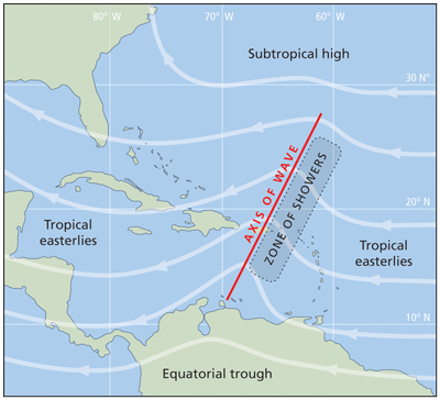
An easterly wave moving west across the Atlantic. These features can be key in the formation of tropical cyclones. |
|
Pat Rossi illustration |
During the period from about August through November, an “easterly wave” (EW) commences transit westward across that box every four to seven days and, given the right environment, it can be the genesis for meteorological mayhem: the tropical cyclone (TC). They’ve carried multiple names — tropical wave, tropical easterly wave, etc. — but they all refer to an elongated trough of low pressure, its axis oriented roughly north-northeast/south-southwest. Not every North Atlantic TC has its start as an EW, but the fact that most destructive ones do again invites the question: How is Cape Verde associated with tropical cyclones? Turns out that it isn’t. Having launched from the northwest African coast, Cape Verde is a waypoint — an on-ramp for EWs hitching a ride with the northeast trade winds.
The trough’s trailing (eastern) edge experiences falling pressure, converging and rising humid surface air that, once aloft, cools and condenses. Clouds form, and precipitation along with thunderstorms and gusty winds result. The leading (western) edge of the trough completes the cycle with descending and diverging less humid air, rising pressure and a clearing sky. Satellite views of that box can show parallel columns of troughs moving slowly westward with alternating intervals of clearing — one EW a few days ahead, another a few days behind. From there it will fade, amble along or, given the right conditions, develop the destructive power of a TC.
En route west, those mobile troughs choose a sort of “Goldilocks” gap — not too far north, nor too far south, but “just right” — brushing shoulders between two parallel zones that would be unfavorable to storm growth.
To the north of about 30° N is the potential block by the Azores High. That block isn’t all bad however; in its clockwise rotation, around the mid-latitude high, it acts as a gear whose teeth are moving westward in the southern portion of their arc, helping to impel that low in the same direction.
On the other side of that Goldilocks gap, from about 10° N to the equator, the Coriolis effect fades to zero and thus is no help in regard to steering, etc. This is one reason why a TC rarely forms in those latitudes. So what comes next for one of those westward-moving arcs of unsettled weather? Perhaps a little deepening at one point along the line, perhaps a slight bit of passing wind sheer to give a little twist or torque? It’s ironic that at this stage, a “little” sheer is a help to get the ball rolling (or rotating), but that later on in the developed state, sheer is an enemy to TC growth.
—Jim Austin, a Naval Academy graduate who served on a USN destroyer and cruiser, is a retired physician living in Burlington, Vt.