In the age of satellites and computers, flag signals and Morse code are largely relics from the past, at least for most recreational yachtsmen. Signal flags are mainly relegated to dressing ship, and Morse code can be seen mainly on charts indicating the characteristics of light buoys and racons. Horn signals and light signals still have an occasional role in ship-to-ship communication, but these too have been largely replaced by more modern means of identification and collision avoidance. And how many of us even have a proper ship’s bell on board anymore?
Advancements in the technology of marine communications over the past few decades have produced a wealth of opportunities for rapid and precise communication between ships and between a ship and the shore. This review of my communications gear on board Cielita, my J/46 fiberglass sloop, isn’t intended as a comprehensive review, but may be of assistance to those considering how to outfit their vessel for offshore passagemaking.
The following is a list of the specific communication equipment we currently carry aboard Cielita for passagemaking in the North Atlantic and Arctic regions.
VHF radios – one fixed, two hand-held
HF SSB radio
Cell phones – two or more
Iridium satellite phones – one fixed, one portable
Small walkie-talkies
Laptop computers – two with WiFi capability
SkyMate satellite system
Weather fax demodulator
Pactor modem
Navtex receiver
A.I.S. transponder
EPIRBs – one category I, one category II, one personal hand-held
Note that this list does not include all the non-electronic means of emergency or distress communication, such as flares, smoke signals, whistles, signal mirrors, strobe lights, radar targets, and the like; and it assumes various means of receiving and integrating GPS signals.
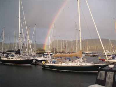 |
|
Ned Cabot’s J/46 Cielita alongside the dock in Scotland. Ned Cabot |
VHF radio
The first five on my list can be used for voice communication, although the first four have some data capabilities as well. VHF (very high frequency) radios are certainly ubiquitous on almost all boats. Even the smallest of vessels, including many dinghies, carry a VHF radio. Until the advent of cell phones, the VHF radio was the principle means of voice communication for vessels in coastal waters. The once-familiar marine operator that patched calls through to shore phones has all but disappeared entirely from U.S. coastal waters. But in many parts of the world it is still possible to be connected to shore phones by VHF coastal stations. And the VHF radio is still the norm for most ship-to-ship voice communications, which can now be made private conversations with the advent of DSC (digital selective calling). And the VHF is still the quickest and easiest way to contact the coast guard in an emergency. In U.S. waters one can also get continuous weather broadcasts from NOAA 24/7, and in many other countries there are regularly scheduled weather broadcasts via VHF radio. So the VHF remains the single most useful communication tool as far as ship operations are concerned. But its range is limited to line-of-sight, meaning the VHF is of little use when trying to talk to a station more than 40 to 50 miles away, depending, of course, on antenna height.
Cell phones
Today, cell phones have become a very popular means of voice communication in coastal waters and can be used for some data reception, as well. Cell phone coverage has become extensive in the more populated parts of the coastal world, making this form of voice communication popular, prolonged, and private. But cell phone service can be quite expensive, especially if roaming charges apply, and it rapidly becomes useless when more than a few miles offshore. Furthermore, if you don’t know the cell phone number of the guy on the bridge of that freighter bearing down on you, you’d better have some other way of getting his attention.
HF SSB
So, what about voice communication offshore, on the high seas, and over long distances? Before the era of satellite communications, the only option was high frequency (HF) single sideband (SSB) radio. This remains a very viable option with no associated service charges. But the cost of installation is considerably greater than a VHF radio, in part because an SSB radio requires an extensive ground plane, a fixed antenna, and an antenna tuner. Furthermore, selecting an appropriate frequency and tuning the radio is considerably more difficult than with a VHF radio given the need for ionospheric bouncing of the signal, which is influenced by the distance between stations, as well as such things as the time of day and sun spot activity. Nonetheless, HF SSB radio can be a very useful piece of equipment for the offshore sailor, not only for routine and emergency voice communication, including cruising networks, but for receiving weather information and, it turns out, for uploading and downloading data, as discussed below.
Satphones
However, nowadays, communications satellites abound, and the satellite phone has largely replaced the SSB for most offshore voyagers requiring voice communication. There are several different satphone systems. Some are more affordable than others. We chose the Iridium satphone because it requires only a small antenna, it can be made portable, and it has world-wide coverage. Furthermore, the satphone also turns out to be a good way to send and receive data. The Iridium phone can be set up to act as a modem connected to your computer. There are many software compression programs that make it possible to send and receive e-mails and other data, but the bandwidth is limited and transmission of data is slow, so sending or receiving big attachments can be a very slow and expensive undertaking, and surfing the Web is quite impractical. For those who need much broader bandwidth, there are more robust satphone systems available, but they are a good deal more expensive, and we have so far decided to forego access to the Web when offshore.
Of course, if you’re tied up in a modern marina, you may find you have access to a WiFi node. Since most modern laptops have WiFi capability, this may be an option for gaining Web access in harbor, but you have to be very close to a node to get adequate reception. There are devices you can attach to your computer to try to enhance reception, but in my experience so far, they don’t add much. Furthermore, although your computer may be able to “see” several nearby nodes, they are often locked, and many require the purchase of Web access for a given period of time. If you’re on the move from harbor to harbor, this can get expensive. The same can be true of Internet cafes ashore. On the other hand, if you can gain affordable access to the Internet, there is a wealth of information available to the voyager on the Web, especially weather data.
Navtex
But the real challenge is how to economically transmit and receive data, such as e-mail, weather fax, GRIB (gridded binary) files, and the like, when offshore on the high seas, out of rage of WiFi and cell towers and VHF radio. Today there are quite a number of solutions to this problem. One that has been around for a number of years is Navtex. This world-wide system of radio stations that broadcast text weather information and notices to mariners regionally at specific intervals over a fixed high radio frequency is available within about 200 miles of shore in most parts of the world. The easiest way to receive this data is via an independent, dedicated Navtex receiver with its own antenna and its own readout screen. The unit can be programmed to receive only the types of broadcasts of interest from the regions of interest, and most units store this data serially until the user decides to delete it. Such a device draws extremely little current and can be left on 24/7 while it slowly accumulates the desired information and notices that can then be quickly reviewed and discarded or stored. And all this data is received for free!
A fairly common but potentially expensive means of both transmitting and receiving data is the satphone, when it’s connected to the computer using the appropriate software. On Cielita we have been using the Iridium phone for sending and receiving e-mail for the past nine years. The system can be a bit tricky to set up and obviously requires an account with an Internet service provider (ISP) that is linked to the Iridium system. Since you pay by the minute for air time on the Iridium system, you need a good compression algorithm and a pre-paid SIM card to keep the costs down. Our ISP for Iridium is StratosNet. They have a free help line available world-wide 24/7 and an excellent mail server software program that we now use called AmosConnect.
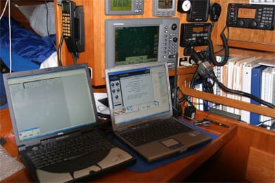
 |
|
Cielita’s nav station with its array of navigation and communications gear. Ned Cabot |
SkyMate
Another completely independent satellite-based system we have aboard is called SkyMate. This separate device can be hidden behind the nav station panel and is connected to the computer. It has its own antenna out on the radar pedestal (next to the Iridium, Navtex, and GPS antennas) and uses an independent system of satellites to receive and transmit data to the boat from shore stations that are, in turn, connected to the Internet by land lines. But unlike the satphone, this system does not transfer data in real time. It stores data both coming and going in its “black box” and batches the data up to and down from one of its satellites only when one such satellite is in view over the ship. The data is relayed to one of the SkyMate portals ashore when the satellite gets there, and from there to the Internet. Instead of paying by the minute, you pay by the character with this system, but it has e-mail capability, and you can ask for specific weather data by return mail. It will also send out automatic GPS reports to a list serve that you set up on whatever schedule you choose. The beauty of this system is its independence from all other systems, so it is a very handy back-up system for both e-mail and weather reports. However, unlike Iridium, a significant shortcoming of SkyMate for us has been the limited or non-existent satellite coverage in high latitudes. We have found so far that above 60° to 65° N it is unable to connect to a satellite. But in the lower latitudes, such as U.S. coastal waters, for example, it’s very easy to operate and a pretty nifty system, albeit moderately expensive to use.
Weatherfax
If your boat is equipped with an HF SSB radio, it too can be harnessed to transmit and receive data. For example, graphic weatherfax data is transmitted on a range of different frequencies by a number of government agencies around the world. In the North Atlantic we have been most familiar with weatherfaxes emanating from the U.S. Coast Guard in Boston, the Canadian Cost Guard in Halifax, the British Met Office in Northwood, and the Hamburg Met Office in Germany. To make use of this data, it must first be demodulated from the analog radio signal to a digital format that your computer can read, store, and display using the appropriate software. We use a simple, little demodulator and its corresponding software from Xaxero called WeatherFax 2000. When the system is up and running, we can leave it running in the background on our computer, where it downloads and stores an almost endless stream of weatherfaxes until we are ready to look at them and discard the ones we’re not interested in. This is an extremely useful source of weather data for the offshore voyager, and the data is completely free.
Pactor digital HF SSB
But an even more versatile use of your SSB is to connect it to your computer by means of a Pactor modem. This “black box” that can live out of sight behind the nav station panel also demodulates the analog radio signal and converts it to a digital format your computer understands. But, with a membership subscription to SailMail (www.sailmail.com) and the necessary AirMail messaging software download, it does a lot more. Among other things, it can do e-mail and receive weatherfax and GRIB files on request, after paying an annual subscription fee of $250. The Pactor II-USB modem we installed connects to the computer via a simple USB port and is able to automatically tune the SSB to the desired frequency for the nearest shore station in the SailMail system, which is essentially world wide. Setting this system up for the first time is a bit complicated, but we were able to pull it off without professional assistance. Once it’s operational, it’s easy to use and a really slick way to do e-mail and get weather data such as GRIB files at no additional cost.
AIS
Another important communications modality we have come to rely on heavily is the automatic identification system (AIS). Although this might be thought of as a navigation tool, it’s really a form of ship-to-ship and ship-to-shore communication. With an AIS transponder installed and either connected to the computer with the appropriate charting software installed or connected to its own, independent readout, the system allows us to “see” the ship traffic around us for up to 10 miles or more and allows others to “see” us. The system works by a fixed VHF (and therefore line-of-sight) radio signal that transmits and receives data in pulses and can tell us the lat/long, speed, course, call sign, and type of vessel that may be bearing down on us, and also calculates the CPA (closest point of approach) and TCPA (time to closest point of approach) for each vessel in the neighborhood. When operating near busy shipping lanes, this is critically important information for collision avoidance. When operating at night or in the fog it is particularly useful. It draws very little current, and we leave ours on whenever we are underway so we can see and be seen by others.
EPIRB
Finally, we should mention EPIRBs (emergency position indicating radio beacons) under the heading of marine communications. These are devices one hopes to never have to use, but every vessel venturing offshore should have at least one registered 406 EPIRB. When activated in an extreme emergency, such as a man overboard or the threat of sinking, when outside professional help is urgently required to prevent loss of life, the activated EPIRB sends a signal via satellite to the nearest rescue control center, which, in turn, notifies the nearest search and rescue station. Some EPIRBs transmit a precise GPS position to facilitate rescue crews, but no EPIRB is of any use if it is not properly registered and maintained.
We have tried to give a picture of the kinds of communication technology currently in regular use from the perspective of this particular ocean voyager. The technology is constantly changing, and no doubt there will be new ways of communicating at sea in the near future. Although it’s often hard to keep up with these rapid changes, it is the responsibility of the prudent skipper to do so — and it’s also part of the fun and challenge of going to sea.
————
Ned Cabot is a retired surgeon based in Boston.