From north to south, the western coastline of Ireland trends in a southwesterly direction; the prevailing winds are from the southwest. It doesn’t take a genius to recognize that a north-to-south passage has to involve a fair amount of windward work, aggravated by the more-or-less permanent westerly swells that sweep in from the Atlantic, with the next bit of solid ground being Labrador over 1,500 miles away. But what’s to be done if the boat is in Scotland and you want to get to the Channel Islands, and you’ve heard just how spectacular the west coast of Ireland can be? Somewhat too late, you realize these reports have come from cruisers sailing in the opposite direction.
It was also unfortunate that Terrie and I, with our grown-up children Pippin and Paul, chose to make the passage in what has been reported to be the worst “summer” in Scotland and Ireland in 40 years. We began our passage during the first couple of weeks of June in persistently cold, wet and miserable weather reinforced by three gales as we worked our way from Oban to Port Ellen on Islay, our jumping-off point for Ireland; it didn’t get much better after this. For the next month, the B&Bs had vacancy signs, the fishermen were complaining of all the lost days because it was too rough to go to sea, the visitors’ moorings were empty and we hardly saw another cruising boat.
 |
|
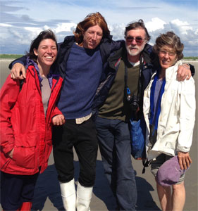
The Calder family: Pippin, Paul, Nigel and Terrie on Rutland Island. |
The north coast
From Port Ellen, a reported weather window encouraged us to set sail for Lough Swilly in what promised to be reasonable conditions, leaving at 0300 to catch a favorable tide across the North Channel. In practice we found rough seas as we close reached in 15-25 knot winds with the tide opposed to the wind. By the time we made landfall at Malin Head (mostly hidden in low clouds and rain showers) the tide had turned and was running hard against us. The wind died. It took us an unpleasant couple of hours to motorsail through confused seas into Lough Swilly, and a further couple of hours to work our way to Buncrana against the outgoing tide. Swells followed us into the lough, making for a rolly anchorage off the town. We crept into shallow water on the south side of Inch Island to find a comfortable spot for the night.
Buncrana was our jumping-off point for shoreside trips to Derry, a fascinating not-to-be-missed walled city that has made a remarkable comeback from the dark days of the ‘Troubles’.
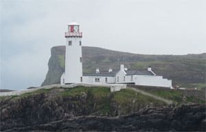
Protected anchorages on the north coast of Ireland are few and far between. With the wind solidly in the southwest, we reached back up Lough Swilly, hardening the sheets as we rounded the magnificent lighthouse on Fanad Head, and then doggedly motorsailing in unpleasant seas until we reached the lee of Horn Head at Dunfanaghy Bay. Here we found a calm overnight anchorage fronted by miles of gorgeous sandy beach.
 |
|
Buncrana on Lough Swilly was the first stop in Ireland for the Calders. |
We sailed out of the lee of Horn Head and continued the tiresome process of working to windward in lumpy seas aggravated by an underlying Atlantic swell. Impressive cliffs dwarfed small fishing boats operating along their base. We came across a mass of diving terns, razorbills and guillemots; a few casts of a fishing line pulled in 10 mackerel.
We rounded Bloody Foreland and shut down the motor, sailing the remaining miles into the lee of Arranmore Island, and then following the leading marks up the narrow, rock-bound channel into Burtonport. While in center channel our chartplotter showed us traveling over the land, a disconcerting experience that was to be repeated several more times while in these waters, emphasizing the need to not place undue reliance on electronic navigational aids (on a couple of other occasions, the GPS plot skipped backwards and forwards by almost two-tenths of a mile). We anchored outside the harbor, perfectly protected in the lee of Rutland Island, with fresh mackerel for dinner.
On the nose
With a prediction of fresh southerly winds, I chose to motorsail directly south from Burtonport into the lee of the Slieve League Peninsula, expecting thereafter to be able to sail comfortably westwards in relatively protected waters inshore along the peninsula, renowned for its stunning scenery, and to then tack and continue sailing eastwards along the southern shoreline once we had rounded Rossan Point. Instead we found headwinds on both sides of the peninsula; the wind shifted almost 180 degrees (is this, perhaps, a peninsula effect, given the massive cliffs that dwarf even those of Horn Head?) with low cloud and drizzle obscuring the coastline. When the southerlies finally asserted themselves, we had a pleasant sail the last few miles into the protected harbor at Killybegs, anchoring between fleets of laid-up factory fishing vessels.
 |
|
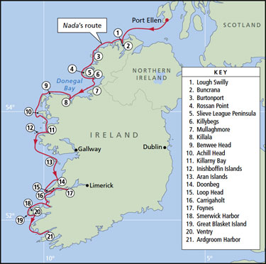
The Calders’ route along the west coast. |
|
Pat Rossi/Navigator Publishing |
The wind was back in the southwest. After an initial beat out of Killybegs Harbour, we set sail south towards Mullaghmore Head. We were able to crack the sheets in winds gusting to 30 knots. Substantial swells swept in from the Atlantic, becoming steep and close to breaking as the waters shoaled approaching the headland. Even with two reefs in the main and genoa, we were accelerating to 10 knots in the gusts and rolling the side deck under, giving me a sense of how rapidly you could get into broaching conditions in these waters.
A Louisiana interlude
At Mullaghmore we connected with friends, Michael and Denise, from Louisiana. The wind continued to increase from the south. In spite of the short fetch in the lee of the headland, the chop was building in the anchorage. Overnight we had gusts to almost 40 knots. Nada was yawing from side to side, coming up short on the anchor rode at the limit of each swing, and alternately heeling to port and starboard. Terrie and I finally gave up trying to sleep and sat out in the cockpit on anchor watch, with the wind gradually abating as daybreak approached.
We set sail in the morning with a prediction of 15-knot southerly winds. In practice, what we had was consistently above 20 knots, gusting to 30, but coming off the land so not kicking up any substantial seas. We sailed on a fast, close reach under reefed genoa alone, WSW to Killala, stopping en route to explore the uninhabited island of Inishmurray with its numerous impressive monastic ruins. There is no decent anchorage at the island. We dropped the hook in a marginally acceptable location off the small “harbor” on the south shore, with Nada bucking in the short, steep seas. I stayed aboard on anchor watch while the others dinghied into a natural cut in the rocks, looking for sufficient shelter to beach the dinghy without being swamped. The seas continued to build while they were ashore such that on the return trip to Nada, the dinghy and crew pretty much disappeared in the wave troughs.
 |
|
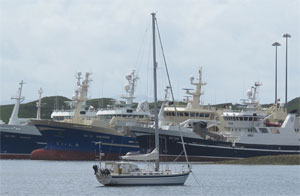
The Calder’s Malo 46 Nada anchored at Killybegs, home port of a large Irish fishing fleet. |
We crossed the shallow bar at the mouth of the Moy River about midway through the flood tide. A 2- to 3-knot current swept us up the channel, with its three sets of excellent range markers, to our anchorage in a pool behind Bartragh Island. The wind was blowing 20 knots and more against the tide, raising a steep chop with Nada surging alternately to wind and current hard enough to snap our half-inch nylon anchor snubber (a first for us). We replaced the snubber and dinghied into Killala, a charming fishing village with numerous ancient buildings, including a 12th-century ‘round tower’, and the usual warm and friendly Irish welcome. By the time we returned to Nada the wind had died and Nada was lying peacefully, the prelude to a relaxingly quiet night. We were treated to a spectacular sunset as we dined on an excellent Louisiana gumbo cooked up by Michael and Denise, sipping single malt Irish whiskey.
A southerly wind enabled us to sail westwards close inshore in reasonably smooth seas with a favorable tide and intermittent sunshine along a truly amazing coastline. From Kilcummin to Downpatrick to Benwee, one spectacular headland gave way to another, with each more dramatic than the last, until we rounded Erris Head (which is not nearly as impressive as the other headlands) and hardened the sheets for a relatively short beat outside Eagle Island, tacking back into a protected anchorage at Frenchport.
 |
|
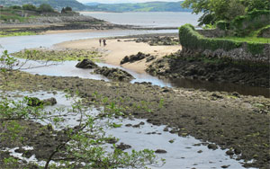
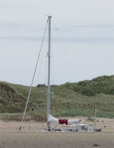
Nada nearly disappears at low tide in the sandy estuary at Killala. |
Achill Head and Sound
The coastline trends SSW from Frenchport to Achill Head; our wind was from the SSE at 20-30 knots, with substantial swells barreling in from the southwest. We put two reefs in the main and genoa and sailed close-hauled inshore between the mainland and a string of offshore reefs and islands. These provided reasonable protection from the swell until the last few miles of the approach to Achill Head. Lulled into a false sense of security, I opted to round the headland close inshore. Now with little protection from the swells, the seas became rough and confused. Achill Head has the highest cliffs in the British Isles. The wind alternately dropped below 10 knots and then came whistling down the cliff faces at over 30 knots. We were taking a lot of water over the bow for a short while in some of the most unpleasant conditions we have ever faced, and in spite of the two reefs the stronger gusts rolled the side decks under. Nada was being bounced around to a considerable extent; the crew was somewhat unnerved. I certainly would not have wanted to do this in a less seaworthy boat.
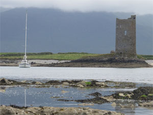
Once past Achill Head, our course was dead to windward. I tried dousing the genoa and motorsailing with the main as a steadying sail, but the going was tough and slow. We bore off and motorsailed four miles in a southerly direction, after which we were able to tack and sail close-hauled in increasingly comfortable seas as we came into the lee of Clare Island. We entered the protected waters of Achill Sound on the last of the ebb tide and motored up the channel, escorted by a pod of dolphins, to anchor in front of the picturesque square keep of Kildavnet Castle. In spite of sand banks all around us, the anchor dragged over rock when first set, but took a hard bite on the second attempt. It was only after the flood tide had kicked in that we realized we had anchored in the path of its full flow, which we clocked at up to 3.7 knots, and which presumably sweeps the bottom clean of sand.
 |
|
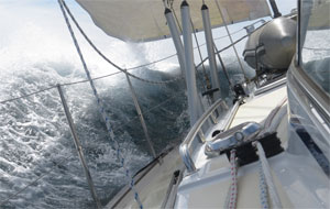
Reaching in swells on one of the trip’s rare sunny days. |
Yet another gale was predicted. It at least had the decency to come through in daylight. By 0730 the next morning the wind was gusting to 25 knots with the anchor chain dragging noisily across the bottom as Nada yawed from side to side. We were soon seeing gusts over 30 knots. I was worried the anchor would pop loose from whatever rock it had grabbed, so we maintained an anchor watch until the wind eased in the afternoon. The anchor held firm until the worst was over and then dragged. We reset it and it dragged again. I moved Nada into the center of a big circular eddy formed by the tidal current and re-anchored where there was little current, close to a drying sandbank. We found sand with the anchor holding well and just about enough swinging room to avoid going aground at low tide.
Crew change
The aftermath of the gale brought light southerly winds. We motored the few miles due south to Clare Island and picked up a mooring to roam around this lovely island on a glorious, sunny day. However, the mooring field is somewhat exposed. With more heavy weather approaching, we sailed in the late afternoon close-hauled 10 miles into the protected waters of Little Killary Bay, exploring the beautiful wooded shoreline, reminiscent of childhood explorations of Exmoor valleys, in the last of the evening light.
Michael and Denise, and Pippin and Paul, were leaving us. They had arranged to be collected by a cousin of Denise’s who arrived the next morning. We put the four of them ashore in truly filthy weather with heavy rain and a southerly wind gusting to 25 knots and predicted to increase to gale force. After they had left, Terrie and I pulled up the anchor and sailed to Inishbofin Island under a severely reefed genoa in winds now gusting to 35 knots but coming off the land so not kicking up any nasty seas until close to the entry into Bofin Harbour, which faces to the south. Here we found substantial onshore swells as we entered an unfamiliar harbor. The atmosphere on board was tense until we rounded the point crowned with Cromwell’s ruined barracks and entered relatively protected water.
 |
|
Pippin takes in the bold cliffs as Nada rounds Benwee Head in County Mayo. |
We set our anchor too close to the mooring buoys so we reset it, but then it dragged (it was fouled with weed), forcing us to reset it once again. We were none too happy about the holding given the approaching gale. We went ashore between rain showers and found a fisherman willing to lend us his mooring and return to Nada to pick it up. This provided a substantial measure of comfort during an uncomfortable night in which the wind shifted into the southwest with residual swells rolling around Cromwell’s barracks into the anchorage.
The next day Nada was rocking and rolling in persistent driving rain as the gale came through. On its backside we had light to moderate northwest winds — perfect for making headway to the south. We began with a fast reach, which transitioned to motoring with the main as a steadying sail, as the wind faded before filling in sufficiently from astern for us to sail around the somewhat notorious Slyne Head. The beam swells were high enough to intermittently completely obscure the lighthouse as we sank into the troughs. We continued sailing southerly for several miles with the wind on our starboard quarter then gybed for the Aran Islands, sailing downwind with a preventer on the boom and a poled-out genoa. Nada was rolling heavily at times in the swells and light wind, periodically noisily backwinding the main and shock loading the rigging. The china was clinking in the kitchen cabinets. In the evening the wind faded altogether; we motored the last few miles, anchoring in calm waters outside the mooring field in Killeany Bay. An otter charmed us by fishing close to Nada.
 |
|
A tour boat runs the channels at Inishboffin. |
Aran Islands to the Shannon
For a couple of days the wind blew between 15 and 25 knots from the south and southwest, giving us time to explore this remarkable island with its amazing patchwork quilt of dry stone walls and impressive ancient forts perched atop dramatic cliffs. We ducked into any available shelter as one rain shower after another swept across the island and the sun refused to show its face. Then on July 11, the height of summer, we put on extra sweaters and never even set foot ashore as another gale came through with driving rain all day.
The backside of this gale brought 15-knot westerlies. We set sail close-hauled for Loop Head, roughly 40 miles to the southwest, with the residual swells from the gale crashing impressively on the cliffs of the Aran Islands as we moved out of their lee. For a while we were able to lay the rhumb line to Loop Head, but then the wind shifted southerly and headed us. We eased the sheets for a fast, close reach into the protection of Doonbeg Bay.
The following afternoon, the wind suddenly shifted into the northwest at 15 knots — ideal for rounding Loop Head. We immediately raised the anchor and set sail on an exhilarating fast reach on starboard tack around the headland some 20 miles away, with Nada surging comfortably over substantial, long swells barreling in from the Atlantic. We gybed around Loop Head to sail eastwards, now on a fast reach on port tack, into the outer reaches of the Shannon estuary. This perfect wind held until just shy of Carrigaholt. We motored the last mile or so into its protection, anchoring off the castle to complete the best day’s sailing in two months!
 |
|
Waves crash against the bluff front of Loop Head at the mouth of the Shannon. |
Terrie’s sister was flying in from the States with two friends. We rode the tide (3 to 4 knots at times) up the Shannon River to Foynes, stopping en route to explore the magnificent monastic ruins and ancient round tower on Scattery Island. We tied up to the Foynes Yacht Club pontoon where we were welcomed by the commodore. After embarking our guests, we motored in calm winds and flat seas across the Shannon and into the River Fergus to anchor for a peaceful night in the bucolic surroundings of paradise.
Our guests were not experienced sailors and the next gale was on its way. Typically, we prefer to anchor, but we decided a marina berth would be a better option. We rose early to catch the outgoing tide and rode it under genoa alone down to Kilrush in steadily building east winds, entering through the sea lock into the excellent protection of the marina with its exceptionally friendly staff. The wind blew hard out of the west overnight and all the next day, finally easing the following night.
The last leg
We motorsailed out of the Shannon estuary on an ebb tide, which at times ran at 3 to 4 knots against the wind and the Atlantic swells, making for short, steep and unpleasant seas in the shoal waters off Beal Point. Our destination was picturesque Barrow Harbour behind Fenit Island. The entrance is shallow. We arrived soon after low tide, grounding gently on the sand in the lee of the island until the rising tide carried us into the anchorage in front of the ruined castle and off a lovely little beach where we enjoyed a quiet night.
 |
|
Nada moored near the ruins of a fortified tower in Barrow Harbour. |
I was keen to put some southerly miles behind us. We had a forecast of a brief windshift into the southeast, so we made an early start to catch the tide to Smerwick Harbour to the west. The windshift never materialized and instead we were beating into 25-knot headwinds in seas that became increasingly rough and unpleasant as we worked our way inside the Magharee Islands and across Brandon Bay. We gave up, turned tail and enjoyed a spectacularly fast reach into the protection of Fenit Marina.
Next we had a brief forecast of a moderate northwest wind. This held long enough to make it along a dramatic coastline into the shelter of Smerwick Harbour, although one of the crew was decidedly seasick in the somewhat turbulent conditions. Another brief weather window provided the opportunity to continue sailing close inshore past the stunning Three Sisters, with a lobster boat working its pots in what looked to be life-threatening conditions among the breaking seas and high-flung foam along the base of the cliffs. We rounded Sybil Point and headed into the lee of Great Blasket Island, where we were able to anchor, albeit in rolly conditions, and dinghy ashore to a small protected dock set in a crack in the coastline for a truly memorable exploration.
Standing on a promontory on Great Blasket I could look across Blasket Sound to Dunmore Head, the westernmost point of the mainland of Ireland. From here the coastline trends increasingly eastwards, with a multiplicity of beautiful, well-protected anchorages. Later that day, we rounded Dunmore Head in gentle conditions to anchor in the protected waters of Ventry Bay. As if to let us know the hard work was over, the sun was out.
 |
|
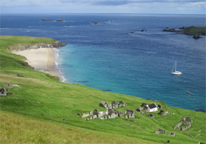
Nada anchored off a pristine beach at Great Blasket Island, one of the westerly outposts on the Irish coast. |
Change direction
On the whole, this is the most stressful cruising we have ever done. The challenges take the edge off the pleasure of this remarkably beautiful coastline and its spontaneously friendly and generous people.
The temptation is to seize a favorable wind to reel off as many miles as possible, but then you miss out on numerous spectacular sights and various lovely anchorages. But every time you round one of the headlands, you have to give up ground to gain a protected anchorage. While you stop to enjoy these places the prevailing southwest wind reasserts itself, leaving you with another unpleasant slog to windward.
It seems to me there really is no substitute to exploring this coastline from south to north rather than north to south. Or maybe the answer is to simply pick a summer with fewer gales and less miserable weather!
Contributing editor Nigel Calder is the author of numerous bestselling marine books, including Boatowner’s Mechanical and Electrical Manual.