Many boaters are using their smartphones and tablets to display electronic charts. Now Technology Systems Inc. (TSI), a small company based in Brunswick, Maine, is taking this electronic chart trend further with an intriguing product called SmartChart AIS (smartchartAIS.com).
This smartphone app (currently only available for Android, but with an iPhone version coming soon) blends electronic elements with NOAA electronic nautical chart (ENC) data and video to produce something it calls “augmented reality” (AR). Not only that, the company is pushing its own flavor of automatic identification service (AIS) that it calls Class E AIS. Yet another intriguing aspect of SmartChart AIS is that its development has been supported by a Department of Homeland Security (DHS) Small Business Innovation and Research Program contract.
According to TSI’s founder and chief technical officer, Chuck Benton, SmartChart AIS has its genesis in a Defense Advanced Research Projects Agency and Navy program with the tongue twister name of Augmented Reality Visualization of the Common Operational Picture (ARVCOP). ARVCOP evolved into a system that TSI currently supplies to the U.S. military called Mapping and Visualization Real-time Collaborative Software (MAVRCS). Benton said this was TSI’s first use of smartphones as a platform.
The military background of SmartChart AIS is rooted in what the military calls the “Common Operational Picture.” Benton wrote in an e-mail that this is “a fancy phrase for what most call socially networked software.”
While the term “virtual reality” is well known thanks to the rise of video games and goggle-like wearable displays that block out the real world, the idea of AR has long been used in military applications. A good example of AR is the heads-up display (HUD) used in fighter aircraft. A HUD projects tactical information onto a clear screen so a pilot can see it, but it doesn’t block out the real world beyond his cockpit. It adds to reality rather than replacing it. One example of AR most people have seen is the first down marker used for football on television.
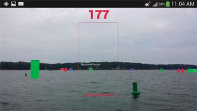
TSI has taken a similar approach with its SmartChart AIS app. In the augmented reality function you use the smartphone’s video camera to view the world around you. Also shown superimposed on the video picture are user-specified elements from the electronic chart such as buoys, marinas, or points of interest you may have marked on the chart (such as the location of your boat when you go ashore), etc. The SmartChart AIS software uses inputs from the phone’s sensors to gauge the phone‘s orientation, calculates the range and bearing to, say, a buoy and then displays it on the screen at the appropriate location.
The benefits to this AR approach are readily apparent in rain, fog or darkness, when you need to enter or depart a harbor or are sailing along an unfamiliar coast. Another benefit to AR is a bit more offbeat. As Benton pointed out when we talked at the Newport International Boat Show, when you’re getting a dinghy ride back to your boat after an evening of revelry and you’re not completely sure where your boat is, SmartChart AIS’s AR can help you deal with your own “augmented reality.” As long as you marked the position of your boat before you left, you can use the SmartChart video display to direct the dinghy driver to your vessel.
In addition to the AR function, SmartChart has its own flavor of AIS. It allows you to see AIS Class A and B vessels on the app’s chart just as if you had an AIS receiver. Additionally, you can see the position, speed, heading and other data of fellow users of SmartChart AIS. TSI calls this capability Class E AIS. Rather than using the official AIS VHF reporting function, TSI’s Class E uses cellular phone networks to report your position every five seconds (if your vessel is moving) to TSI’s remote computer server. The server then places you on the electronic chart for your area and provides that data to you and other users in your area. The process occurs via the Internet. The TSI server provides you with the NOAA ENC for your location; there is no chart data stored on your phone.
TSI’s AIS Class E designation has not been officially sanctioned by the Coast Guard or the Radio Technical Commission for Maritime Services (RTCM). However, according to Benton, the company has made maritime authorities aware of what its doing regarding Class E. “We’ve briefed the Coast Guard, RTCM and a NATO conference on maritime and harbor security,” Benton said.
While there are major benefits to the average boater, there is another angle to the Class E reporting function. It allows not only other boaters but towing services, marine police, the Coast Guard and, of course, DHS to track you as well. According to Benton, DHS statistics indicate that only a small fraction of boaters are using AIS transceivers. The Coast Guard and DHS would like to see most boaters using AIS, either A, B or TSI’s Class E, both to aid search and rescue operations and for maritime security reasons.
In addition to its AR and AIS Class E features, SmartChart AIS also incorporates Active Captain info on marinas, fuel docks, ramps, pump-out services, etc. It also provides social networking functionality that allows users to send messages and share waypoints, pictures, and more. And users can view weather radar feeds on the app.
This is not an offshore-friendly app. Since the charts and the Class A, B and E vessel positions are provided via the Internet, once outside cellular range, the app won’t work.
TSI is currently offering the SmartChart AIS app for free, with plans for a more advanced version, SmartChart AIS Plus that will carry a price tag and will include offline charts.