Voyagers deciding on a cyclone avoidance strategy in the South Pacific need to make some decisions. That was certainly true for my wife Cat and I aboard Anna, our Tayana 37 cutter. We could stay in the Society Islands at 150° W longitude for cyclone season and play the odds — roll the hard six, so to speak. While the Marquesas offered a reduced risk of a direct hit from a severe cyclone, the increased convection from this El Nino year in an area closer to the equator could spell trouble. Especially in the limited, exposed, crowded and rolling anchorages that are typical in that archipelago where the holding is questionable and where everyone needs to be packed in like sardines. Not a good situation if the weather falls apart, which it could in a heartbeat. By comparison, the options for safe anchorages for riding out severe weather in the Societies are better. The downside is the higher potential for severe weather.
Severe-weather computer modeling has improved over the years. While the probability of a direct hit in our area of the central South Pacific is at a rather alarmingly high percentage of 90 percent, there are enough problems associated with projected forecast anomalies — to say nothing of accurately projecting the track of a cyclone in progress and pinpointing its landfall — for us to think that percentage is too high.
 |
|
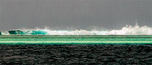
Wave energy is dissipated on the outer reef of Huahine. |
Our rationale is that we’ve been tracking the gridded binary files (GRIB) for months now and have seen only a modest correspondence to real-world conditions in the central South Pacific. This, of course, proves nothing in the big picture — atmospheric and ocean conditions are still precarious in terms of heightened potential for the genesis of cyclones approaching or developing in French Polynesia — but it does tell us that when modeling severe weather on a day-to-day basis nothing is guaranteed. A cyclone track can turn on a dime and often does as it approaches the boundaries of French Polynesia. In fact, we often find that the computer models are so unreliable that planning even a short- to moderate-distance ocean passage based upon up-to-date GRIB file data is frustratingly unreliable.
GRIB files
Even when GRIB files are downloaded six to 12 hours apart, they can be wildly different and offer no consistency. So while looking at visible and IR satellite imagery to project storm tracks is a reliable real-time tool, it still leaves a lot of speculation when modeling the complex dynamics of severe weather 24 to 48 hours out — the minimal time required to prepare the boat for a serious threat.
 |
|
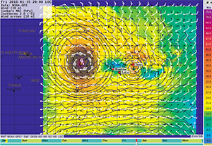
An intense low breaks in two with the smaller feature passing close by the Society Islands. |
The root of the problem this year is unstable El Nino conditions that can best be described as an unprecedented anomaly. The computer models are only as good as the programmers and analysts that build them (and no doubt about it, they are very good at what they do), but the calculus is so unfathomably complex that the government and military Cray computers that run the simulations have a difficult time keeping up in such a hyper-dynamic weather environment.
We have twice tried to time our departure from Tahiti to coincide with a good weather window for arriving at the Marquesas Islands 10 to 14 days later, only to get turned around within 48 hours of departing Tahiti by unexpected and unfavorable conditions. The GRIBs were way off the mark. The rule of thumb with a GRIB is that they can reasonably be expected to have a high confidence, if analyzed correctly, for at least the first 24 to 48 hours. Then the confidence tapers off a bit from 48 to 72 hours out and, finally, at greater than 96 hours out it’s anyone’s guess as to what will happen. So when a GRIB changes radically, only six to 12 hours out, confidence in its accuracy is diminished.
 |
|
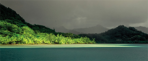
Port Bourayne is one of Huahine’s excellent cyclone holes. |
Observing real-world conditions and then comparing this to the GRIB data and local weather forecasts for consensus is the best you can do when it comes time to decide whether or not to go. Taking a leap of faith that there is nothing truly bad on the near-term horizon before departing, along with a good measure of luck, is what it takes when it comes to picking the so-called ideal departure time for an extended passage. The GRIBs were wildly wrong both times we attempted to leave Tahiti for the Marquesas, but of course we couldn’t know that until we ventured out and gave it some time. In a normal weather year we most likely would have completed the predominantly upwind passage with less weather-related complications to deal with. But we’re not talking about normal weather this year, which brings us to where we are now, why we are here and why not somewhere else.
Scoping out a cyclone hole
First and foremost, we do not want to endure a severe cyclone. This year, cyclone genesis is anticipated to occur farther east in the South Pacific — that is, closer to the central South Pacific rather than farther west in the South Pacific. In an El Nino-neutral year, cyclone formation typically occurs farther west at approximately 170° E, tracking closer to Vanuatu, Fiji and Samoa than French Polynesia. Historically, and especially in a strong El Nino year, cyclones have had a tendency to develop farther to the east and even as far as the longitude of the Marquesas group at 139° W. This, however, is truly atypical behavior. The Marquesas are considered reasonably safe from the path of direct cyclone threats in an El Nino-neutral year and even in light to moderate El Nino cycles. We spent the last cyclone season in the Marquesas (in an El Nino-neutral cycle) and felt no effects of cyclones that had come close to or brushed the Society Islands, 900 miles to the west. So with this in mind we thought that returning to the Marquesas to escape the potential for cyclones was a reasonably good idea, if not exactly bulletproof in a strong El Nino year.
 |
|
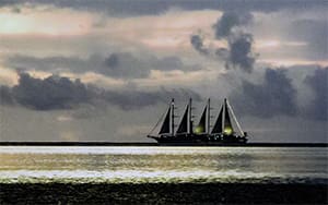
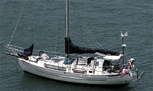
Anna at anchor. |
How does a tropical disturbance turn into a tropical cyclone? Here is a case of just that happening: The tropical disturbance update on Dec. 29, 2015, from RSMC Nadi-Tropical Cyclone Centre in Fiji (a meteorological agency tasked with tracking tropical depressions, storms and cyclones, and providing timely warnings in our part of the world, Nadi for short) indicated three deepening tropical systems: TD05F, TD06F and TD07F. These three systems were picked up on Dec. 27, 2015. All three of these depressions had a potential to develop into a cyclone within the following 24 to 48 hours. On Dec. 29, TD05F had been upgraded from low to moderate risk, to a high risk of developing into a tropical storm or cyclone within the following 18 to 36 hours. Two of these neighboring depressions could twin up and morph into one intense system as well. All three of these systems were located in the western South Pacific and tracking slowly east by south.
The next day TD06F dissipated, while TD07F slowly intensified. And nearby TD05F, deepening rapidly, was upgraded to a Category 1 tropical cyclone named Ula.
 |
|
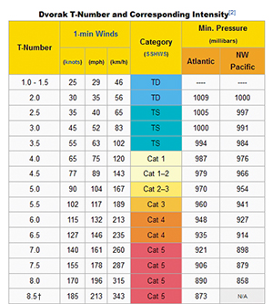
Chart shows Dvorak T numbers and corresponding intensity. |
On Dec. 31, 18 hours later, Ula was bumped up to a Category 2 cyclone, and just 12 hours after that it met the criteria for a Category 3 cyclone with sustained winds at the center of at least 65 knots and gusts up to 85 knots. Both Ula and TD07F were on a reciprocal course near the Fiji/Samoa/Tonga triangle. They had the potential to twin up or potentially cancel out. Alternatively, one or both of them could recurve to the east if the deep layer ENE flow that was driving them to the WSW diminished. This is why we track a cyclone or any tropical disturbance if we are positioned within 500 to 1,000 miles of its center.
On Jan. 1, 2016, TD07F dissipated and was taken off the watch list, but Ula continued to intensify as a Category 3 cyclone with sustained 80-knot winds near the center and gusts at more than 100 knots. Ula was forecast to begin diminishing within 48 hours on her SSW course but could recurve to the northwest and intensify once again. On Jan. 6, 2016 Ula was downgraded to a Category 1 cyclone, diminishing to 35 knots on a northwest course — recurved, but still diminished. A couple days later, Ula re-intensified with winds of more than 115 knots and showed no immediate sign of dissipating.
 |
|
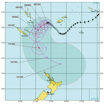
A track of the cyclone Ula showing how a storm’s course and intensity can change rapidly. |
Meanwhile, further to the north and east, another developing serious low-pressure system began to intensify much closer to the Societies. It had forecast sustained winds pegged at 97 knots and gusting to 115 knots according to the GRIBs (five to seven days out). The difficult part was predicting the exact track. On one day, the GRIBs had this system tracking to our north and east. On another, the GRIBs had it tracking to the west of us and then turning southeast. In addition, it appeared to be twinning up with another deep low that developed to our east. Huahine, the island with our hurricane hole, lies in a zone that was directly between the two systems.
Cyclone development
All of the tropical systems we’ve seen were picked up by the global computer model, and their trajectories and wind strengths were predicted with good accuracy. Meteorologists in the South Pacific rely heavily on the Dvorak method when analyzing a cyclone’s stages of development and thus category strength. Visible satellite imagery reveals the shape (a cyclone has classic developing stages or patterns) when not obscured by cloud cover, and IR satellite imagery can help to identify these patterns through their heat signatures. The emerging satellite imagery patterns are compared to the classic shape of a cyclone at a particular stage of development and assigned a designation known as a “T” number, typically T-1 to T-5. When a cyclone reaches the T-5 stage, it is well formed. The T-1 to T-5 cycle usually lasts five to seven days.
Our confidence in the latest round of analysis and severe-weather forecasts has risen somewhat. Global computer models appear to be tracking well in relation to real-world weather, although the forecasts haven’t exactly nailed the duration correctly. Ula’s actual track was close to what the GRIB model indicated, but she persisted much longer than forecast and increased in intensity when she was expected to diminish. We rely on accurate analysis to determine our severe weather strategy. For our boat Anna, this means knowing when a cyclone is tracking our way and having the time to prepare the boat — and ourselves — should one become imminent. We figure the best strategy is to remain anchored either in or close by a hurricane hole until the season of cyclones, coupled with this unusually strong El Nino cycle, nears its predicted end.
Rich and Cat Ian-Frese live aboard their Tayana 37 Anna while voyaging in the South Pacific. Rich is a former research engineer.