When discussing weather and weather forecasts, the term “front” is used frequently. And, sometimes misused. Therefore it is worth spending a little time learning about fronts, clearly defining what they are, what type of weather can be associated with them, and why they are important to ocean voyagers.
A good place to start is a definition. From the American Meteorological Society’s Glossary of Meteorology we find the following: “The interface or transition zone between two air masses of different density.” The most significant parameter of atmospheric air relating to density is temperature. This helps lead to another way to state the definition by noting that a front is a boundary between air masses of different temperature.
The most common misuse of the term occurs when people speak of a front “moving into” a region. This implies that a front enters a region and then remains for some period of time. However it is important to remember that a front is only a boundary, and thus once it has passed through a region, it is no longer present. The air mass following the front can remain in a region for a period of time, and, by definition, will have different characteristics than the air mass that preceded the front, but the front itself is just the boundary, so unless it stops moving, its presence is only fleeting.
|
Figure 1
|
|
Ken McKinley |
|
Chart symbols used for fronts. |
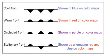
There are several different types of fronts, and the weather map symbols for these are shown in Figure 1. Warm fronts and cold fronts are named to indicate the relative temperature of the advancing air mass. Both are boundaries between warm and cold air masses, but in the case of a cold front, the colder air mass is advancing and replaces the warmer air mass as the front passes, and for a warm front, it is the warmer air mass that replaces the colder air mass with the frontal passage. Although fronts are depicted on surface weather maps with lines that show their position, they are actually three dimensional in nature, and examining this three-dimensional structure helps lead to an understanding of the weather associated with the different types of fronts.
Cold front
A cold front, by definition, is a boundary between advancing colder air and retreating warmer air. Because colder air is denser, the advancing cold air mass will wedge underneath the retreating warmer air mass, and force the warmer air mass to ascend. Because of the laws of physics, the rising warm air will cool, and eventually will reach its dew point, allowing condensation of water vapor to begin, which leads to the formation of clouds. Often, the warm moist air will be unstable, meaning that once condensation begins in the rising air, its ascent will continue, leading to clouds of vertical development. These are cumulus clouds, and if the frontal force and/or instability are great enough, they will grow to greater heights and become cumulonimbus clouds, which are associated with thunderstorms. Thus a cold front is typically associated with a showery type of precipitation, including thundershowers, which can become strong or severe under some circumstances. See Figure 2.
Warm front
By contrast, a warm front is a boundary between advancing warmer air and retreating colder air. Recall that colder air is denser (and thus heavier), so it will tend to remain near the surface, and the advancing warmer air mass will ride up over the retreating colder air mass. As with the cold front, this lifting will lead to cooling of the air mass, and eventual cloud formation. Typically with a warm front, though, the slope of the frontal surface is much more gradual, leading to a slower ascent. The result is usually a larger area of more layered, or stratified clouds which gives rise to a large area of steady precipitation. Occasionally, if the warm air is unstable, some thunderstorms can be embedded within this large area of precipitation, but usually more violent weather is associated with cold fronts rather than warm fronts. High thin cirrus clouds are observed well in advance of a warm front, then as the front approaches, clouds become thicker and also lower as precipitation breaks out. See Figure 3.
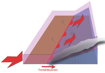
| Figure 2 |
 |
|
Ken McKinley |
|
Cold air mass (in blue), wedges underneath warm (pink), forcing warm air to rise (red arrow), producing vertical clouds and leading to thunderstorms (green arrow). In the northern hemisphere, cold fronts typically extend southerly from lows. |
Cold fronts typically follow warm fronts, and move more quickly, so they will often overtake warm fronts. When this occurs, the warm air mass that lies between the fronts (ahead of the cold front, and behind the warm front) is lifted right off the surface of the earth, leading initially to heavy precipitation, and possibly thunderstorms, but as the process moves along, precipitation will become lighter and more intermittent as most of the moisture is condensed out of the lifted air mass, leaving less moisture available to generate precipitation. Figure 4 depicts a simple cross sectional diagram of the occlusion process.
Stationary front
A stationary front is simply a boundary between air masses of different temperatures which is not moving. This means that neither the cold air mass nor the warm air mass are advancing, thus large scale ascent is not being forced, but airflow along the front will usually still involve some component that allows for some of the warm air to be lifted over the colder air, so clouds and some light precipitation are possible with a stationary front.
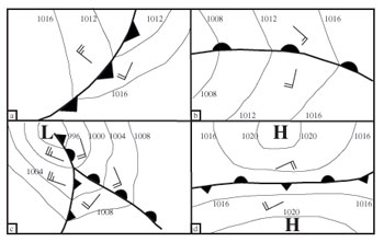
All fronts lie in a trough of low pressure at the surface. This means that when crossing a front at right angles, the atmospheric pressure will be lowest at the front, and will be higher on either side. This often results in isobars changing direction as they cross a front, and the change in direction can be somewhat sharp, particularly for cold fronts. Figure 5 shows typical arrangements of isobars around cold fronts (a) and warm fronts (b). Since mid-latitude lows tend to develop along the boundary between two air masses, it stands to reason that there will be fronts associated with these lows. The development of these lows is a complex topic, which I will not deal with here. In general, cold fronts will extend in a southerly direction from a well-developed northern hemisphere low, and warm fronts will extend generally to the east. Occluded fronts will begin to develop near the center of a low later in its life cycle and will extend outward with time. Figure 5(c) shows a typical arrangement of an occluded front, cold front, and warm front around a northern hemisphere low.
In all of these cases, notice how the isobars change directions at the fronts. This is of critical importance for a mariner, because it indicates an abrupt shift in wind direction as a front passes a vessel’s position. The shift in wind direction typically also means a change in sea state, and frequently a period of confused seas for a time following a frontal passage as the seas produced by the winds in advance of the front will not abate immediately following its passage, and will combine with the seas produced by the winds behind the front.
In other situations, fronts will lie between two areas of high pressure with no isobars crossing them (Figure 5(d)). In these situations, the front is still a boundary between two different air masses (represented by the two highs) and there will still be a wind shift across the front — in fact the wind shift in this situation can be 180 degrees. The frontal boundaries in these situations are usually stationary fronts, and may not be associated with much precipitation. Stationary fronts in this type of arrangement are often the breeding ground for lows.
| Figure 3 |
 |
|
Ken McKinley |
|
Warm air mass (pink), rides over cold air mass (blue), leading to layered clouds and a large area of steady, sometimes heavy rain. In the northern hemisphere, warm fronts typically extend easterly from lows. |
Stationary fronts may also arise when the tail end of a cold front moves into lower latitudes, slows down, and stalls. Often the wind shifts across these types of stationary fronts are more subtle, and the weather is not as active as in higher latitudes. At this stage of the front’s life, the two air masses that it divides have usually evolved to the point where they are not that different, and within a short time as the air masses become quite similar, the front will cease to exist.
A Pacific example
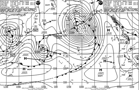
Of course, all of this can be termed “textbook” information. Let’s take a look at a real world situation to see how everything fits together. Figure 6 is a surface weather chart for the Pacific Ocean. The large low centered south of the Aleutian Islands has an occluded front which extends initially north-northwest away from the low, then curls around to the northeast, east, and southeast, ultimately extending south to about 47N/150W. From that point (termed a triple point) a warm front extends southeast, and a cold front extends southwest through the central Pacific. The kinking of the isobars is difficult to discern around the occluded front, which is not unusual when dealing with such a strong low, but it can be seen with the cold front. West of the dateline, the cold front evolves into a trough of low pressure, shown as a dotted line continuing west through the tropical latitudes. This portion of the front could probably have been considered a stationary front for at least a portion of its length, but the message being shown by the chart is that the air mass contrast across the dotted line is becoming minimal, and the front is dissipating in this region.
Elsewhere on the chart, a low is located in the western Pacific just west of 170E, and this low also has an occluded front extending to a triple point with a warm front and cold front extending away from the triple point. The cold front becomes a stationary front as it extends generally west between two highs. There is also a short stationary front located just west of this low extending north-northeast to a weak low center near 50N/170E indicating a non-moving boundary between air masses — warm to the east and cold to the west — and a 180 degree wind shift is likely across this front. And finally, a strong low is located in eastern Russia to the north of Japan with an occluded front extending a short distance to its south-southeast, then a cold front extending south-southwest through northern Japan and into the Sea of Japan. The kinking of the isobars around this front is a bit easier to see.
| Figure 4 |
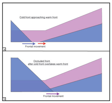 |
|
Ken McKinley |
|
Formation of occluded front. a: cold front approaches warm front, b: cold front overtakes warm front. |
By noting the position of fronts on surface analysis charts and comparing these to forecast charts that show the expected future positions of fronts, you can anticipate the weather the front will bring. Certainly the weather conditions associated with the fronts as described above are important, but of more importance is knowing that conditions will change abruptly with the front passage. Changes in temperatures, cloud cover and precipitation should all be anticipated, but most important is the change in wind direction and sometimes wind speed across the front which will have the greatest impact on a vessel at sea. Also, anticipate changes in sea state connected with the change in wind direction. It is always wise to plan for a period of confused seas following a frontal passage, and in some cases just prior to a frontal passage as well.
| Figure 5 |
 |
|
Ken McKinley |
|
Pressure patterns and fronts (northern hemisphere). a: Cold front, b: Warm front. c: Occluded front. d: Stationary front between two highs. |
| Figure 6 |
 |
|
Ken McKinley |
|
A Pacific surface analysis chart. |
———–
Ken McKinley is a professional meteorologist, the owner of Locus Weather in Camden, Maine.