Bruce and Sheridan Fahnestock were lucky young men. Born into privilege and good connections, they were able to turn their social position into both personal and social advantage during the Great Depression. While America was reeling with more than 30 percent unemployment, the Fahnestock brothers, along with some friends, were able to purchase a schooner and sail off to the South Pacific on an expedition collecting flora and fauna for the American Museum of Natural History.
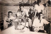
The brothers were the sons of a successful inventor, growing up in Manhasset, N.Y. They inherited their father’s curiosity and by 1934, were ready for a scientific expedition to the Pacific Islands. Bruce, the elder of the brothers, had graduated Brown University and was going as ship’s chronicler, entomologist and record keeper. Sheridan, at 21 years, was skipper. Rounding out the crew was Dennis Puleston, Wilson Glass, George Harris, and John Green. Hugh Davis, at 25, the eldest of the crew and the director of a zoo in Oklahoma, went along as photographer and herpetologist.
The ship they chose was an older pilot schooner named Director that had worked for 23 years in Portland, Maine. Director was solidly constructed, planked with three-inch oak over oak frames, 59 feet LOA, with a 16-foot beam and a 10.5-foot draft. There was also a fussy inboard engine that was a source of constant headaches. The boys needed a stout craft, for they intended to sail around the world via the Pacific. On New Year’s Eve 1934, they departed New York in stormy conditions, under storm trysail and foresail, making a nonstop run to Panama.
From Panama, they sailed to the Galápagos then on to the Marquesas, Tahiti, Samoa, Tonga, the New Hebrides, and the Philippines. Along the way, they wrote pieces for the New York Herald Tribune, Harper’s Magazine, and The New Yorker. They all contracted malaria in the Philippines and had to stop. They arrived back in New York as sensations, went on speaking tours, and wrote a book, Stars to Windward.
While in the Pacific, they became fascinated with the music of Bali and Indonesia that was fast disappearing. They outfitted a larger schooner they dubbed Director II and went back to the Pacific to record indigenous music.
Using only celestial navigation, Director was able to sail through some of the most treacherous waters in the world with never a misstep. It is due to their great seamanship and good luck that they avoided major mishaps.
Let’s join them aboard Director in the South Pacific waiting for a noon sight. We will use the 2012 Nautical Almanac. Height of eye is 15 feet. It is April 15 and Sheridan is taking a lower limb sight of the sun. He is doing this as standard procedure to confirm latitude. The ship is on its way from the Galápagos Islands to the Marquesas and at a dead reckoning (DR) of 7° 35’ S by 115° 25’ W. The Hs of the sun at noon is 72° 06.8’.
A. What is GMT of LAN at the DR?
B. What is the Ho?
C. What is the latitude?
Answers
A. Time of LAN is 19:41:40
B. Ho is 72° 18.6'
C. Latitude is S 7° 33.9'
Long solution
Once again we do the simple yet so elegant solution to finding latitude using a noon sight. Also known as Meridian Passage sight, latitude can be found using any celestial object when it crosses the meridian of the observer. Of course, both the object and the horizon must be visible but I have done meridian passage shots of Jupiter on nights when the full moon provided enough ambient light to reveal the horizon. The sun, though, is the easiest celestial object to use in order to find latitude. The procedure is not difficult and in the great days of sail often the noon sight was the only sight ever used. When you do a noon sight think about the LHA and celestial triangle. What is the LHA at noon? What does the celestial triangle look like? Thinking about it is a great way to visualize just what is going on out there in the great beyond.
Okay on to the problem. We are doing a lower limb shot of the sun on April 15 2012. The Hs is72° 06.8’. The height of eye is 15 feet and the DR of the vessel is S 7° 35’ by W 115° 25’. We want the GMT of LAN, the HO and the resulting latitude.
Calculating the time of LAN in GMT is straightforward. On the day on question we go to the bottom of the daily sun pages and find the time for MER. PAS. is 12 hr and 0 minutes. Next we go to Conversion of Arc to Time Table and discover that it takes the sun 7 hrs 40 min. to travel 115° of longitude from the Greenwich Meridian. It takes another 1min 40 sec. for the sun to move 25’ of longitude. (The DR longitude is 115° 25’ W).
12hr 00 min
+7hr 40 min
+1min 40 sec
19hrs 41 min 40 sec GMT time of LAN at DR latitude
At about that time the shot is taken of the Lower Limb of the sun. The Hs is 72° 06.8’. We need to reduce that to the HO
Hs 72°06.8’
-dip 3.8’
App alt 72°03.0’
3rd cor + 15.6’
HO 72°18.6’
Next we need to find latitude using the formula Lat = 90°-HO = ZD+/- Dec
By inspection at the 19 hrs on April 15 on the sun pages in the NA we see that the Dec of the sun is N 10° 06.9’. Because they were 40 minutes past 19 hrs when they took the sight (exact time is not essential for the noon sight) the navigator moved the declination a bit further north since he saw that the sun was moving north at 0.9’ per hour so he decided that a good declination at the time of the shot was N 10° 7.5’. This he will deduct from the ZD. Why he deducts it is a matter of common sense based on his DR and where he was yesterday, course steered etc. so we have
90°
-72° 18.6’
ZD= 17° 41.4’
-dec 10° 7.5’
Lat= 7° 33.9’ S