Ocean voyagers are interested in the winds along their routes for obvious reasons, whether voyaging under sail or under power. Gathering information about expected wind speeds and direction for a voyage is a key component of the decision making process that will determine the exact route of the voyage, the timing of the departure, and whether intermediate stops are made and how long their duration may be. As part of that process, many mariners have educated themselves about global wind patterns and the forces that produce wind. However, there are some areas around the world where these general principles fail, and this article will examine some of these areas.
Recall that wind is produced by differences in atmospheric pressure from one area to another, which is termed the pressure gradient. The pressure gradient pushes air from areas of higher pressure toward areas of lower pressure. Because the Earth rotates, though, large scale windflow exhibits a deflection known as the Coriolis effect. That deflection is to the right of motion in the Northern Hemisphere, and to the left in the Southern Hemisphere.
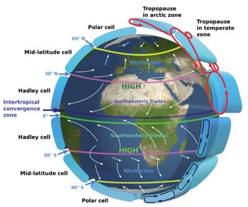
With this in mind, let’s take a look at the general global circulation patterns. Without going into a great deal of detail, the general wind patterns found where most mariners voyage are generated by subtropical high pressure (Bermuda High, Azores High, Pacific High, and corresponding systems in the Southern Hemisphere), the Intertropical Convergence Zone (ITCZ), and low-pressure systems that track generally from west to east in the mid-latitudes well poleward of the subtropical highs.
 |
|
Figure 2: This chart of winds in the vicinity of the Leeward Islands chain of the eastern Caribbean shows how trade winds blow through the gaps between the islands. |
This means that air will tend to flow from the subtropical latitudes (higher pressure) toward the equatorial region where the ITCZ (lower pressure) is located. In the Northern Hemisphere, this air will be deflected to the right of its motion, resulting in the northeast trade winds. Similarly, in the Southern Hemisphere, the air moving north from the subtropical high will be deflected to the left giving rise to the southeast trade winds. The process is similar poleward of subtropical high pressure with air moving toward the general region of lower pressure in higher latitudes and being deflected by the Coriolis effect and producing the prevailing westerlies in both hemispheres.
Figure 1 shows these general regions of wind and will be familiar to those who have done any reading on the subject or taken a seminar or class. While this diagram provides a reasonable depiction of wind patterns around the globe, it does have a few shortcomings, and these lead us to the discussion of areas where observed winds can be significantly at odds with what the diagram shows and what can be expected.
The diagram assumes that the ITCZ lies at the equator all the time, and this is not the case. Because the distribution of land versus ocean is greater in the Northern Hemisphere, and because of seasonal migration of the large scale atmospheric features, neither of which is accounted for in the theoretical diagram, the ITCZ is more frequently north of the equator than south of it, and during the Northern Hemisphere summer season can be significantly farther north. This has implications for prevailing winds in Northern Hemisphere trade wind regions.
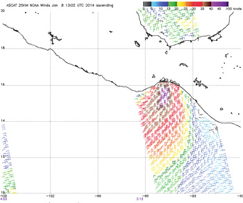
 |
|
Figure 3: Surface pressure chart during moderately strong “Tehuantepecer” gap wind event. Note higher pressure in the Gulf of Mexico, several isobars over SE Mexico, but much wider spaced isobars over Pacific. |
Also the wind patterns shown in Figure 1 assume that the surface of the Earth is featureless and uniform. Because this is not the case (land in some areas, ocean in others), the surface pressure patterns are not uniform belts of pressure, but show variations due to the differing nature of the surface. In particular, subtropical high-pressure centers tend to prevail over the oceans with lower pressure over land areas at similar latitudes. This leads to differing wind directions within the regions of the prevailing westerlies.
Let’s look at some specific regions where these factors come into play.
Atlantic and Pacific waters north of the equator
During the Northern Hemisphere summer months, the ITCZ is often as far north as 10° N to 12° N in both the Pacific and Atlantic oceans. This leads to prevailing winds in the region between the ITCZ and the equator that are much different than the basic theory would suggest. If we go back to the basic idea that air will flow from high pressure toward low pressure, and be deflected by the Coriolis effect, we can find the reasons behind this. As air moves from the Southern Hemisphere subtropical high north toward the equator, it will be deflected to the left of its motion, and this results in the southeast trade winds in this area, as expected. However, once this air moves north of the equator, the Coriolis deflection reverses, and the result is now winds from the southwest in this zone, rather than the expected northeast trade winds.
 |
|
Figure 4: ASCAT image taken at same time as Figure 3 chart. Compare the two charts and note the isobars over the Pacific give no indication of wind strength or wind direction. Note how far offshore strong winds extend. |
This is a particular concern for ocean voyagers who are departing from the Panama Canal on their way to the south Pacific. The first part of this voyage is often the most difficult with headwinds for more than 700 miles until reaching the area of the Galápagos Islands. Once into the Southern Hemisphere, winds will gradually settle back into the southeast trades, which will be favorable for continuing the passage. During the Northern Hemisphere winter, the ITCZ is usually not as far north, but is still north of the equator in this area, so some headwinds are still likely, but the duration is generally not as long.
Northern Indian Ocean
The effect of seeing the ITCZ shift north during the Northern Hemisphere summer is magnified greatly in the northern Indian Ocean because of the arrangement of land and water in this region. As the Indian subcontinent heats up in the summer, pressures become lower over the land area, and the ITCZ shifts all the way north into northern India. This sets up the monsoon circulation in this area with steady southwest winds blowing from the Indian Ocean onto the land, and eventually this flow rises over the Himalayan Mountains leading to substantial rain in these areas. Over the waters, the persistence of the southwest winds during well established monsoon flow leads to higher seas and a change in prevailing currents. As in the Atlantic and Pacific, according to the theoretical diagram, northeast trade winds would be expected in this area, and in fact these do prevail during the Northern Hemisphere winter season when the ITCZ shifts back south toward the equator.
West coastal waters of the U.S. and Mexico
In the case of changes in the westerlies due to the presence of subtropical high circulations over the oceans rather than continuous belts of high pressure around the globe, one of the more noticeable regions where this affects the winds is the west coastal waters of the U.S. and Mexico. In these areas, because the pressure is higher within the Pacific high center offshore and lower over the much warmer land areas, especially in the summer months, the pressure gradient is oriented in more of a west to east fashion rather than the north to south fashion that Figure 1 suggests. Once the Coriolis deflection is factored in, we find that winds in these waters are more frequently from the north or northwest, and can be moderately strong, particularly during the summer when interior land areas become very hot, leading to lower pressure, and thus increasing the pressure gradient. This leads to the situation commonly known as the “Baja Bash,” where yachts attempting to move north from Central America and Mexico to California must deal with persistent moderate headwinds, which in turn produce moderately large seas, and lead to a slow and uncomfortable passage. The strategy preferred by many voyagers is to head well offshore, sometimes all the way to Hawaii, before turning back toward the California coast.
A similar situation occurs along the west coast of South America with prevailing winds in the coastal waters of Chile generally from the south rather than having a significant westerly component making southbound passages difficult in that area.
 |
|
Figure 5: When cool air moves out over warmer water it produces instability and allows strong upper level winds to be transported to the surface — in the Gulf of Mexico this is commonly called a “blue norther.” |
In addition to these large scale differences in prevailing winds, there are other areas where more local variations of wind can occur. Going back to weather basics, recall that by examining a surface weather map with isobars, wind speeds and directions can be deduced using the orientation and spacing of the isobars. This will work well in most all areas of the world, but again, there are some notable exceptions, mostly having to do with terrain issues (There’s that nasty land getting in the way of things again!). Let’s look again at some specific situations.
Gaps in island chains
In areas where mountainous island chains exist, the fact that the land areas extend significantly into the atmosphere serves to deflect the airflow around the islands and through the gaps between them. This results in an acceleration of the wind speed in the island gaps to values greater than the spacing between the isobars would suggest. The Hawaiian Islands are a prime example of this situation with widely varying winds through the channels between the islands even when the isobaric patterns in the region are fairly uniform. The Leeward Islands chain of the eastern Caribbean, lying nearly perpendicular to the trade winds in that area offers an example of this, shown clearly in Figure 2.
Gaps in terrain
Gaps in mountain ranges adjacent to ocean areas can also give rise to winds on the water that are very different than the isobars would indicate. In fact, an article in the last issue of Ocean Navigator (Jan/Feb 2014) provided an excellent discussion of voyaging decisions in and around the gap winds that show up on the Pacific side of Central America and Mexico. In this area, when barometric pressure is significantly higher in the southern Gulf of Mexico or the western Caribbean than in the Pacific, air will rush through the mountain gaps to the Pacific waters.
Figures 3 and 4 show a recent situation where gap winds in the Gulf of Tehuantepec were very active. It is most important to realize that the isobars over the water in this case will not show either the strength of the wind or the proper wind direction. Other areas where this phenomenon can show up include the Strait of Juan de Fuca, the Golden Gate, the Strait of Gibraltar, coastal waters of southern France and northern Italy and the Adriatic Sea.
Sea breeze circulations
Sea breezes are onshore winds that develop when there is a very light pressure gradient present, and the sun heats the land during the day allowing a local pressure drop over the land, and the development of the onshore flow. Often the wind speeds associated with sea breezes will be stronger than the larger scale isobars would predict. The effect is reversed at night when the land cools more quickly than the adjacent ocean leading to an offshore wind. These winds are very familiar to beachgoers in the summer as a nice cooling breeze, but will affect those on the water as well, although only for a short distance offshore.
Cold air over warmer waters
During the winter season, when very cold air that originates over land areas flows over warmer ocean waters, it generates a significant amount of vertical instability. This allows vertical motion to occur (both upward and downward motion), which in turn allows stronger wind speeds at upper levels in the atmosphere to be transported to the surface. This will lead to greater wind speed than the isobars would indicate. In the Gulf of Mexico, the situation is commonly called a “blue norther” (Figure 5). Notice that the wind speeds are higher farther offshore where more instability is realized due to warmer water. When this situation occurs over the western Atlantic off the coast of the northeastern U.S., frequently the wind speeds will not be maximized until the air has moved over and downwind of the Gulf Stream.
The point of all of this is something that I learned long ago as a meteorologist, and that is that the words “always” and “never” are best used only sparingly when talking about the weather. Even though the theory has been well developed, and generally well supported, there will be areas and situations where the theory is not directly applicable.
For ocean voyagers, it is important to research on the specific regions you’ll sail in to pick up on any vagaries in the weather patterns. Cruising guides, sailor’s blogs, and talking with meteorologists are all good ways to do this.
————
Ken McKinley earned a bachelor’s degree in Atmospheric Sciences from Cornell University and attended graduate school at MIT. In 1991 he founded Locus Weather.