“On the day we lost the cereal account, I finally decided to go to sea.” Though not as well-known as the opening lines of Moby Dick, with these lines the reader knows there’s an adventure awaiting. Fun loving Eric Newby, 18 years old, left an advertising firm in 1938 and shipped out aboard the four-masted barque Moshulu to work as a deck hand from Belfast to Australia and then home again.
The trip was immortalized by Newby in his book The Last Grain Race, which was published 18 years later in 1956. It is one of the most charming and evocative books ever written through the eyes of a neophyte sailing aboard these great square-riggers.
Newby, who went on to write many other books including A Short Walk in the Hindu Kush and Round Ireland in Low Gear, was that indefatigable travel writer who, armed with a modicum of skills but good humor and the ability to muddle through, had a piquant eye for the people that he met.
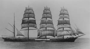
Moshulu was purchased by Gustaf Erikson in 1935 for $12,000. Erikson worked hard to get the last bit of use out of these old square-rigged ships. In 1938, Moshulu was the largest sailing ship still transporting grain from Australia to Europe via Cape Horn. Built as Kurt on River Clyde in Scotland in 1904, the ship was engaged in the nitrate trade, sailing back and forth to Chile from Europe. During World War I, she was seized in Oregon when the U.S. entered the war and her name was changed to Moshulu, which in the Seneca language means “fear nothing.”
In the 1930s, Erikson home-ported Moshulu in Mariehamn in Finland’s Åland Islands. The working language on the vessel was Swedish even though the vessel was registered in Finland.
Learning the ropes, Newby sailed aboard Moshulu to Australia from Belfast in 82 days. In Australia they picked up 4,875 tons of grain and headed back to Europe, arriving 91 days later.
Erikson always drove his crews hard and they were constantly on call. Moshulu had only 28 crewmembers, including four officers, the cook, the steward, and eight sailors in each of the port and starboard watches. This for a ship 396 feet overall, with a 46-foot beam, a draft of 24 feet, with spars as tall as 198 feet above the deck. The vessel carried 34 sails including 18 square sails, three spankers, and 13 staysails. Moshulu was bought and sold after World War II and it is now at Penn’s Landing in Philadelphia.
To get an idea of the courage and good humor of Newby, here is the opening when he reports to the second mate, who wants him to climb the rig. The second mate asks him if he had ever been aloft before. Newby answers no.
“Op you go then…”
“I looked at the mate. He had a nasty glint in his eye and I decided I was more afraid of him than the rigging.”
And up he went.
Let’s join the captain on Moshulu headed east toward Australia in the Southern Ocean on Dec. 20 (use the 2012 Nautical Almanac). The captain is on deck for a morning sun sight. The DR of the ship is S 34° 30’ by E 60° 15’. The skipper takes a lower limb shot of the sun. Height of eye is 35 feet.
A. Calculate time in GMT of noon sight.
B. Hs is 78° 48.1’, what is the Ho?
C. What is latitude from the sight?
ANSWERS:
A. Time of LAN is 07:57 GMT
B. Reduced Ho 78° 58.4’
C. Latitude from noon sight using GHA 07 hours is S 34° 27.4’
Long solution to the Last Grain Race
The DR position of the Moshulu at the time of the sun observation is 34° 30’ S by 60° 15’ E. The height of eye is 35 feet and we are taking a lower limb sun shot at LAN. We want the time for LAN in GMT so we convert longitude to arc and then add that to the time for Meridian Passage found at the bottom of the righthand daily pages of the Nautical Almanac. The day in question is December 20, 2012 and the time of Mer. Pass in LMT is 11:58. Add to that the time it takes the sun to travel 60° 15’ which is four hours one minute of time we then have a Mer Pass. time in GMT of
11:58
– 4 01
7:57 GMT
Notice that we subtracted the longitude from the Mer. Pass time since we are in east longitude.
The Hs of the observation is 78° 48.1’. When reduced, the Ho looks like the following
Hs 78° 48.1’
-dip 5.7’
Aap alt +16.0’
Ho 78° 58.4’
We use the GHA Declination for 0800 hours which is S 23° 25.8’. The d corr is 0.0’
Using the formula for establishing latitude we have Latitude =90° -H0=ZD =/- dec.
We have then 90° 00’
-78° 58.4
ZD 11° 01.6’
+ Dec 23° 25.8’
Latitude S 34° 27.4’
While some may discount the noon sight, it is a tried and true technique and should be second nature to all of you who still use celestial navigation. Keep up the good work!
David Berson