Like may other sectors of society, voyagers have become highly if not wholly dependent on GPS for navigation. What if, however, there was a GPS outage? Would backup systems be available? A small company in British Columbia believes it has an answer to that question and is working on reviving an approach called RadarFix, which was successfully tested more than two decades ago.
The issue of over-reliance on GPS is clearly a greater issue for commercial users moving potentially dangerous cargoes than it is for recreational voyagers. A GPS outage in reduced visibility in coastal waters where there is no easy place to anchor could result, however, in a dangerous situation even for voyagers.
Several studies have been commissioned by government agencies on the vulnerability of GPS signals. One of the first of these was conducted by the Department of Transportation’s John A. Volpe National Transportation Systems Center and was released in August 2001. Entitled “Vulnerability Assessment of the Transportation Infrastructure Relying on the Global Positioning System, Final Report”, it found that “unintentional or intentional GPS disruption could be reduced but not eliminated. GPS cannot serve as a sole source for position location for certain critical applications. Further, backups for positioning and precision timing are necessary for all GPS applications.”
About 10 years before this study was released, a Canadian engineer named Helmut Lanziner and his company, Offshore Systems Ltd., had developed a radar navigation system called RadarFix. By using precisely located and specially designed radar reflectors on shore, the RadarFix system could provide position data that could then be displayed on an early electronic chart.
 |
|
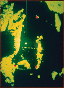
Radar image of RadarFix test area. The red circles have been added to show radar target positions. |
|
Russell Technologies |
The RadarFix software has a table of the surveyed lat/long locations of the reflectors. The software analyzes the geo-referenced radar returns and “looks” at those lat/long positions. It also sees if the returns match the correct geometry between the reflectors located in that area. It quickly matches the geometry and since it knows the lat/long positions of the reflectors, it can use radar range and bearing data to determine its own lat/long position.
In 1989 the RadarFix system was used successfully at Port aux Basques, Newfoundland, on board the 492-foot Canadian ferry MV Atlantic Freighter. It was later also installed aboard the ferries MV Caribou, MV Joseph and Clara Smallwood.
This early version of the RadarFix system ran on the personal computers of that era. The position of the reflectors on shore needs to be known accurately, so the reflectors had to survey using time-consuming pre-GPS surveying techniques. This added cost to the system, restricting the number of reflectors that could be deployed. And obviously since the system required these special reflectors, it did not work in areas where there were no reflectors installed or once a ship went offshore.
In the years since this early application of RadarFix, the concern about GPS dependency has led to several developments. The European Union is building its own version of GPS called Galileo. Four Galileo satellites have been successfully launched and placed in the proper orbits. The first Galileo-only position fix was obtained on March 12, 2013. Further launches are scheduled for 2014 and 2015 and the system is planned to become fully operational in 2019. In another effort to provide a backup system to GPS in the North Sea and English Channel, the General Lighthouse Authorities for the UK and Ireland recently added eLoran capability to the British loran segment of the Northwest Europe loran chain.
Given these developments, RadarFix has a long way to go to before it is a widely available backup to GPS. Technological developments in the past two decades, however, have boosted the potential of the system. As RadarFix inventor Lanziner notes in a RadarFix white paper: “One of the most time-consuming and complex aspects previously was setting up a RadarFix network. This included surveying the reflector/target sites and providing a detailed description of potential targets.”
In a neat technological twist, the availability of today’s precise differential GPS makes this process far less involved and expensive, so new reflectors can be added to the system more easily and inexpensively.
 |
|
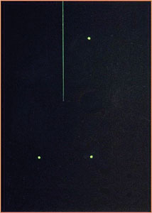
After automatic processing of the returns from the test area shown above, the RadarFix software is able to isolate the three reflectors. |
|
Russell Technologies |
According to Lanziner, an even bigger factor in RadarFix’s improvement is the greater computing power available today compared to 1989. The average smartphone has greater capability than even the most advanced PC of that era. According to the white paper, “The number of targets that RadarFix can now process simultaneously has increased by orders of magnitude. Increasing the number of targets improves position accuracy and reliability.” And another plus of greater processing power is that the system is not restricted to using only radar reflectors. Lanziner wrote in an email, “We discovered that we could also use existing structures as targets, such as jetties, docks, fixed lights and buildings to take accurate range and bearing measurements from. Our ultimate goal is to add reflectors only in difficult areas where there are few existing structures or where accuracies on the order of two meters are required.”
From a maritime security angle, a radar-based system has some advantages over GPS. The main one is that radar signals are more powerful than relatively weak GPS signals and more difficult to jam. Also, a shipboard radar-based system using passive reflectors is totally ship-based and doesn’t rely on outside systems.
Russell Technologies, the current owner of the RadarFix product, is currently porting over the RadarFix software to modern computer platforms. The company is also working on setting up a RadarFix demo system in Vancouver, B.C.
Will RadarFix become a system that voyagers will use? Hard to say, but technology relentlessly advances and computers of the future will likely have plenty of computing power that could make a RadarFix system a viable option for voyaging boats for near-shore and harbor navigation.